Type of salinity and their prevention
There are different types of salinity, each with different causes and varying treatment.
Dryland salinity
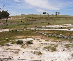 Dryland salinity is the accumulation of salts in the soil surface and groundwater in non-irrigated areas. It is usually the result of three broad processes:
- groundwater recharge (or deep drainage)
- groundwater movement
- groundwater discharge.
Often it results from replacing deep-rooted native vegetation with shallower-rooted crops and pastures, which take up less water. Unused rainwater leaks into the ground causing groundwater to rise and dissolve salts stored deep in the soil. The salty water may:
- rise to the surface causing waterlogging and/or scalding
- emerge at the break of a slope as seeps
- flow over the surface or underground into streams and rivers.
Rising groundwater alone does not automatically cause salinity, but the wide distribution of saline soils in Australia means it is likely that it will mobilise salt stored in the soil.
Dryland salinity may also be caused by the exposure of naturally saline soils such as hypersaline clays, and can be associated with sodic soils (soils with an exchangeable sodium percentage (ESP) of more than 6%).
The NSW Government is working with the Australian Government, local government, farmers and the broader community to treat and prevent the different types of salinity.
The key to addressing dryland salinity is managing excess water in the landscape. This can be done by:
- maintaining adequate vegetation cover
- maximising water use by choosing an appropriate mix of pasture species
- minimising long fallows, using crop rotations and conservation farming methods in cropping areas
- maintaining soil health (fertility, pH and structure) to maximise plant growth.
Under appropriate conditions, salt-affected sites can be treated by:
- keeping stock off the area to allow regrowth
- applying mulch to reduce erosion
- planting salt tolerant grasses, herbs, shrubs and tree species
- adding gypsum and/or fertilisers to help plant growth
- preventing erosion by using contour banks to direct surface water away from the site
- reducing waterlogging by establishing banks and subsurface drains to intercept shallow subsurface water and direct it away from the site
- pumping groundwater to lower the water table.
The NSW Government also provides other detailed resources for land managers who need to assess and manage salinity on the Department of Primary Industries Salinity webpage.
Modelling dryland salinity allows us to:
- assess and compare different actions to manage salinity
- fill gaps where data is limited
- forecast additional data based on our current data in space and time
- predict future trends.
Models help us to understand salinity processes in a landscape. We need to know:
- where is the salt and how much is there
- how salt and water moves
- how geology and landscapes influence movement
- what affects how fast salt and water are moving
- how changing something in one location affects the rest of the catchment or basin.
Several models have been used in NSW to help answer these questions:
Irrigation salinity
Irrigation salinity is the rise in saline groundwater and the build-up of salt in the soil surface in irrigated areas. It is caused by using large volumes of irrigation water that locally raise groundwater levels and mobilise salt. Irrigation salinity is made worse when water used to irrigate is from salty sources.
Irrigation salinity can be controlled by using water efficiently. Crops should receive only the amount of water they can actually use. Reducing water usage in irrigated areas generally requires changes to irrigation infrastructure and technology, and better matching of crops to soil types.
Management and engineering practices that might be used include:
- avoiding over-irrigation by monitoring soil moisture to work out water requirements
- good crop selection such as using deep-rooted plants to maximise water extraction
- minimising fallow periods using crop rotations and break crops
- avoiding deep ripping and overtillage to minimise infiltration of water
- maintaining satisfactory fertility levels, pH and structure of soils to encourage growth of high yielding crops
- using subsurface drainage systems to collect and control water seeping below the plant roots and water entering and/or leaving the irrigation site
- using large bores, or bore fields to draw down the regional water table and maintain it below the root zone and disposing of saline water in special evaporation basins, or in other approved ways.
The NSW Government provides resources on salinity to help irrigators.
 Urban salinity
Urban salinity is a combination of dryland and irrigation salinity processes and is mainly caused by rising groundwater bringing salts to the land surface. The rise in groundwater is caused by blocked or changed natural drainage paths due to:
- urban development
- over-watering of parks and gardens
- leaking pipes, drains and tanks.
In the urban environment, other sources of salt that can contribute to urban salinity include:
- effluent
- building materials
- industrial waste water
- fertilisers and chemicals.
Urban salinity needs to be addressed at the local level and across the relevant catchment. This is because groundwater is affected by actions at both levels.
At the catchment level, prevention involves managing the land as described under dryland salinity.
At the local level, councils and residents should:
- avoid overwatering public parks, sports fields, home gardens and lawns
- plant large native trees and shrubs in open spaces
- replace leaking channels and pipes with corrosion-resistant materials
- minimise groundwater recharge from dams, artificial lakes and drainage basins
- drain water away from infrastructure to avoid ponding
- connect septic tanks to piped sewerage systems where possible
- connect roof drainage to stormwater systems rather than sullage pits (a pit holding the used water from washing clothes and kitchen utensils)
- monitor changes to water table levels and groundwater quality
- establish gardens with low water requirements.
The Local Government Salinity Initiative (LGSI) published a series of booklets to support local government on urban salinity issues.
Industrial salinity
Many industrial processes have the potential to increase salinity levels in rivers. Examples are:
- saline water from mines (working and abandoned) from groundwater seepage and from rainwater coming into contact with mine workings or spoil
- discharged cooling water from coal-fired power stations that has been partly evaporated, concentrating the salt content
- effluent being discharged.
 River salinity
As salty water from areas affected by dryland, irrigation and urban salinity flows into creeks and rivers, the concentration (electrical conductivity or EC) and volume (load) of salt increases. Over time, as salinity within catchments worsens, the quality of river water declines.
Many factors influence electrical conductivity levels but salt load is driven by the volume of water flow.
Much of NSW falls within the Murray-Darling Basin. The Murray-Darling Basin Authority has developed the strategy Basin salinity management 2030 to deliver coordinated salinity management of land and waterways within the Basin.
