Bonville Creek

Our water quality monitoring program has shown Bonville Creek to have fair water quality. Find out more about the estuary and its unique features.

Bonville Creek estuary is situated south of Coffs Harbour at Sawtell, on the New South Wales mid-north coast. It is a barrier river estuary with an untrained entrance that becomes quite shallow and constricted to tidal flows at time, but it usually remains open.

The estuary and catchment area is rich with Aboriginal heritage. The adjacent Bongil Bongil National Park translates to a place where people stay a long time.

Estuary health and features

Water quality

As part of our water quality monitoring program we assess the water quality and ecosystem health of an estuary using a range of relevant indicators. We sample a subset of the estuaries located between the Queensland border and Taree every 3 years. The most recent sampling in Bonville Creek was completed over the 2018–19 summer when 2 sites were sampled on a monthly basis.

Bonville Creek water quality report card for algae and water clarity showing colour-coded ratings (red, orange, yellow, light green and dark green, which represent very poor, poor, fair, good and excellent, respectively). Algae is rated 'fair' and water clarity is rated 'good' giving an overall rating of 'good' or 'B'.

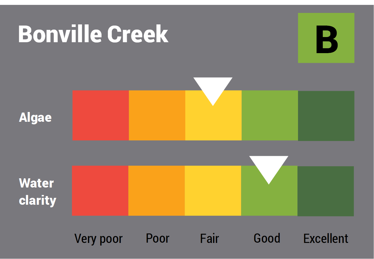
This report card represents 2 water quality indicators that we routinely measure: the amount of algae present and water clarity. Low levels of these 2 indicators equate with good water quality.

The report card shows the condition of the estuary was good with:

  • algae abundance graded fair (C)
  • water clarity graded good (B)
  • overall estuary health graded good (B).

Coffs Harbour City Council, in collaboration with the University of New England’s EcoHealth Program, have carried out detailed ecosystem health monitoring in Bonville Creek. The results of the monitoring program, including a detailed water quality report card, are available on the Coffs Harbour City Council website.

Find out more about our estuary report cards and what each grade means. Read our sampling, data analysis and reporting protocols and find out how we calculate these grades.

We have monitored water quality in the Bonville Creek since 2009. This table shows the water quality grades for this estuary over that time.

Bonville Creek historic water quality grades from 2009 for algae and water clarity. Colour-coded ratings (red, orange, yellow, light green and dark green represent very poor (E), poor (D), fair (C), good (B) and excellent (A), respectively).

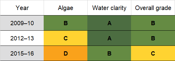
Grades for algae, water clarity and overall are represented as:

  • A – excellent
  • B – good
  • C – fair
  • D – poor
  • E – very poor.

Physical characteristics

Estuary type: Barrier river

Entrance
location
Latitude (ºS) –30.38
Longitude (ºE) 153.1
Catchment area (km2) 113.5
Estuary area (km2) 1.7
Estuary volume (ML) 1466.1
Average depth (m) 1

Tidal exchange volume

Tidal exchange volume or tidal prism data is available for this estuary. This tidal prism was measured in 1997.

Tide state Flow
(106 m3)
Local tidal
range (m)
Sydney Harbour
tidal range (m)
Ebb flow 0.74 0.48 1.4
Flood flow 0.75 0.51 1.52
Notes: km2 = square kilometres; m = metres; m3 = cubic metres; ML = megalitres.

Water depth and survey data

Bathymetric and coastal topography data for this estuary are available in our data portal.

Land use

The catchment of Bonville Creek catchment is mostly forest. Much of the lower catchment remains forested and largely protected by a national park, whereas most of the upper catchment has been cleared, originally for timber harvesting and later for grazing, horticulture and rural-residential development. Around 10% of land use is urban, consisting of the suburbs Boambee East, Toormina and Sawtell.

National and marine parks

  • Bongil Bongil National Park encompasses much of Bonville Creek estuary and its surrounds.
  • This estuary does not flow into a marine park.

Citizen science projects

Community involvement

Bonville Creek

Local government management

Local councils manage estuaries within their area, unless the estuary is attached to a marine park.

Bonville Creek is managed by Coffs Harbour City Council. Information about this estuary can be found on the council’s Bonville Creek webpage.