Bellambi Lake

Our water quality monitoring program has shown Bellambi Lake to have good water quality. Find out more about the estuary and its unique features.

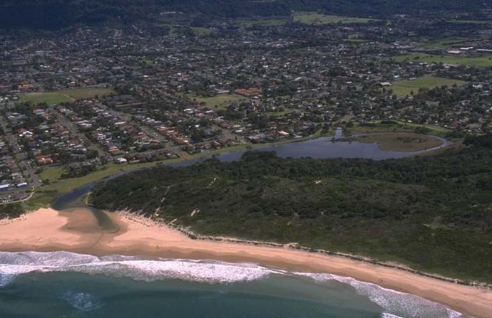
Bellambi Lake is located south of Sydney in North Wollongong. It is classed as an estuarine creek with an intermittently closed entrance.

Bellambi Lake is part of the Bellambi Lake Reserve at Sandpit Point and is an important cultural heritage area for the local Aboriginal community. The reserve includes a lagoon and small islands surrounded by swamp oaks, coastal sclerophyll and saltmarsh.

Estuary health and features

Water quality

As part of our water quality monitoring program we assess the water quality and ecosystem health of an estuary using a range of relevant indicators. We sample a subset of the estuaries between Wollongong and the Victorian border every 3 years. The most recent sampling in Bellambi Lake was completed over the 2008–09 summer when 2 sites were sampled on a monthly basis.

Bellambi Lake water quality report card for algae and water clarity showing colour-coded ratings (red, orange, yellow, light green and dark green, which represent very poor, poor, fair, good and excellent, respectively). Algae is rated 'fair' and water clarity is rated 'good' giving an overall rating of 'fair' or 'C'.

This report card represents 2 water quality indicators that we routinely measure: the amount of algae present and water clarity. Low levels of these 2 indicators equate with good water quality.

The report card shows the condition of the estuary was good with:

  • algae abundance graded fair (C)
  • water clarity graded good (B)
  • overall estuary health graded good (B).

Find out more about our estuary report cards and what each grade means. Read our sampling, data analysis and reporting protocols and find out how we calculate these grades.

Physical characteristics

Estuary type: Creek

Entrance
location
Latitude (ºS) –34.38
Longitude (ºE) 150.92
Catchment area (km2) 1.3
Estuary area (km2) 0.03
Estuary volume (ML) 7.3
Average depth (m) 0.2
Notes: km2 = square kilometres; m = metres; ML = megalitres.

Water depth and survey data

Bathymetric and coastal topography data for this estuary are available in our data portal.

Land use

The catchment for Bellambi Lake is highly disturbed with over 90% of land use changed to urban areas. The towns of Corrimal and East Corrimal to the north of Wollongong, are within this catchment.

National and marine parks

  • There is no conservation area in the Bellambi Lake catchment.
  • There is no marine park associated with the Bellambi Lake estuary.

Area of significance

Bellambi Lake is listed as an area of significance for the Wollongong area as part of Bellambi Lake and Sandspit Point. The area has significant Aboriginal cultural heritage with middens found in the area. It is also contains ecologically important habitat for birds.

Community involvement

  • There are over 60 bushcare groups in the Wollongong area. Bushcare volunteers help regenerate and care for local bushland.
Bellambi Lake

Local government management

Local councils manage estuaries within their area unless the estuary is attached to a marine park.

Wollongong City Council manage this estuary.