Bermagui River

Our water quality monitoring program has shown the Bermagui River estuary to have good water quality. Find out more about the estuary and its unique features.

Bermagui River is a barrier river estuary with an open, trained entrance. It is located on the far south coast of New South Wales and flows next to the town of Bermagui and into the sea at Bermagui Point.

The Bermagui River estuary is popular for activities such as boating, fishing and kayaking. It’s also commercially important for oyster farming and marine operations at the Port of Bermagui.


Estuary health and features

Water quality

As part of our water quality monitoring program we assess the water quality and ecosystem health of an estuary using a range of relevant indicators. We sample a subset of the estuaries between Wollongong and the Victorian border every 3 years. The most recent sampling in the Bermagui River Lake was completed over the 2017–18 summer when 2 sites were sampled on a monthly basis.

Bermagui River water quality report card for algae and water clarity showing colour-coded ratings (red, orange, yellow, light green and dark green, which represent very poor, poor, fair, good and excellent, respectively). Algae is rated 'fair' and water clarity is rated 'excellent' giving an overall rating of 'good' or 'B'.

This report card represents 2 water quality indicators that we routinely measure: the amount of algae present and water clarity. Low levels of these 2 indicators equate with good water quality.

The report card shows the condition of the estuary was good with:

  • algae abundance graded good (B)
  • water clarity graded excellent (A)
  • overall estuary health graded good (B).

Find out more about our estuary report cards and what each grade means. Read our sampling, data analysis and reporting protocols and find out how we calculate these grades.

We have monitored water quality in the Bermagui River estuary since 2011. This table shows the water quality grades for this estuary over that time.

Bermagui River historic water quality grades from 2011-12 for algae and water clarity. Colour-coded ratings (red, orange, yellow, light green and dark green represent very poor (E), poor (D), fair (C), good (B) and excellent (A), respectively).

Grades for algae, water clarity and overall are represented as:

  • A – excellent
  • B – good
  • C – fair
  • D – poor
  • E – very poor.

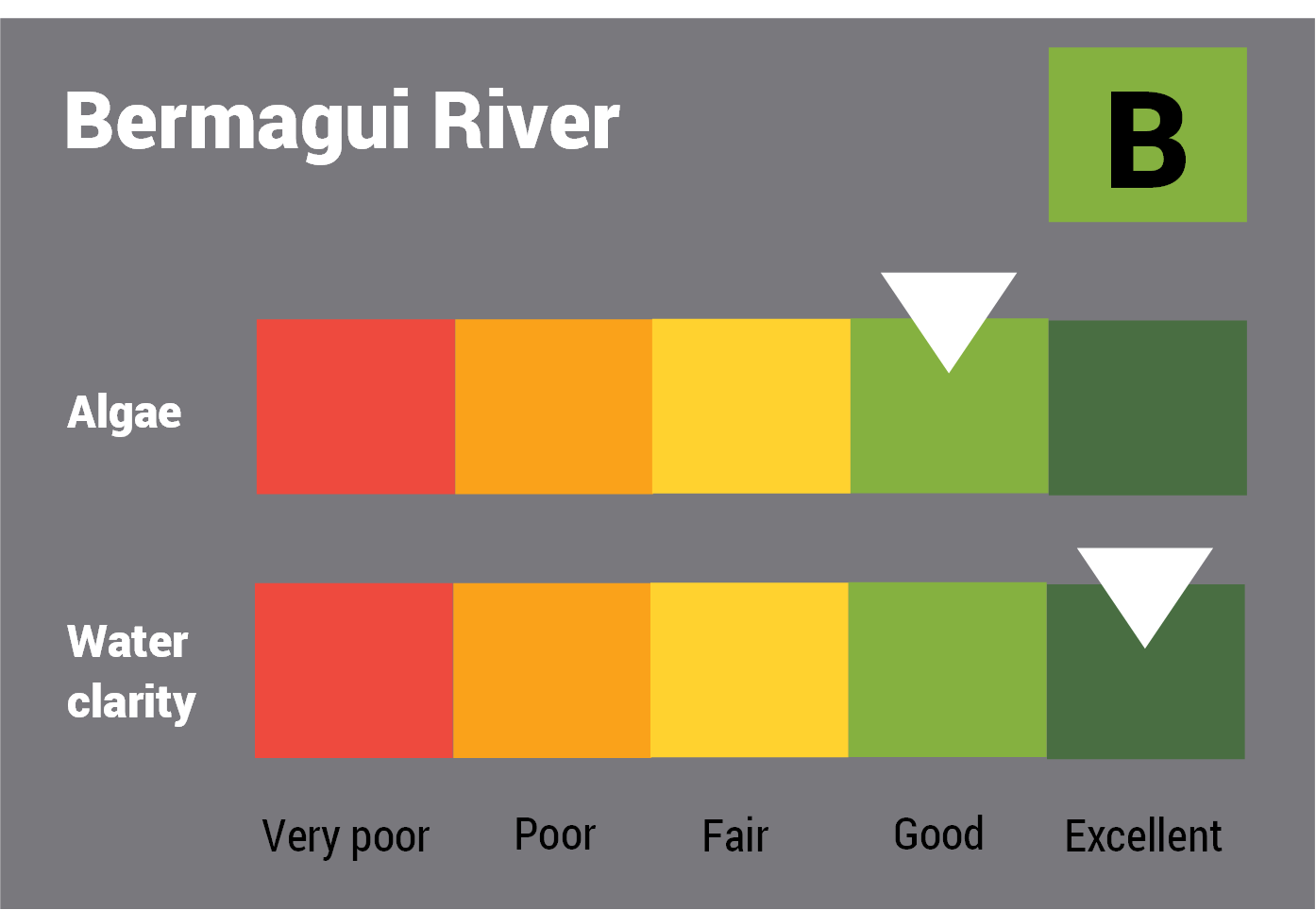
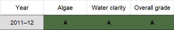
Physical characteristics

Estuary type: Barrier river

Entrance
location
Latitude (ºS) –36.42
Longitude (ºE) 150.07
Catchment area (km2) 83.5
Estuary area (km2) 2.2
Estuary volume (ML) 2160.2
Average depth (m) 1.1

Tidal exchange volume

Tidal exchange volume or tidal prism data is available for this estuary. This tidal prism was measured in 1990.

Tide state Flow
(106 m3)
Local tidal
range (m)
Sydney Harbour
tidal range (m)
Ebb flow 2.5 1.55 1.56
Flood flow 2.5 1.3 1.35
Notes: km2 = square kilometres; m = metres; m3 = cubic metres; ML = megalitres.

Water depth and survey data

Bathymetric and coastal topography data for this estuary are available in our data portal.
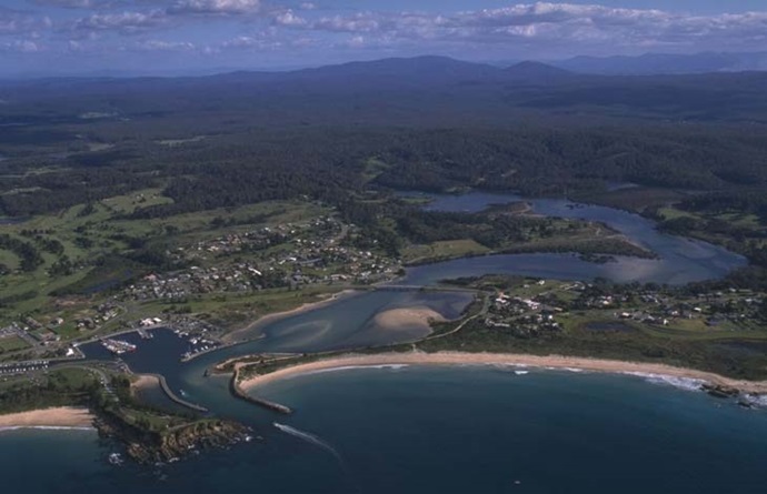
Land use

The catchment of Bermagui River is moderately disturbed with 35% of land cleared for grazing south-west of Cobargo. The urban area of Bermagui occupies 5% of the catchment. Two-thirds of the catchment is forest that encompasses most of Biamanga National Park.

Web cam

The Bermagui River bar crossing web camera provides real-time video of conditions within the river entrance immediately offshore to help with bar crossings and boat safety.

National and marine parks

  • The largest conservation area in the Bermagui River catchment is the Biamanga National Park.
  • This estuary does not flow into a marine park.

Citizen science projects

  • The Far South Coast Conservation Management Network supports the local community to better manage native biodiversity. The network organises citizen science projects, provides information for private landowners, manages a local plant database, and coordinates events.

Community involvement

Local government management

Local councils manage estuaries within their area unless the estuary is attached to a marine park.

Bega Valley Shire Council manage this estuary.