
Crooked River is classed as a barrier river estuary with an intermittently open entrance. It is located on the south coast of New South Wales, south of Gerringong.
Crooked River
Our water quality monitoring program has shown the Crooked River estuary to have fair water quality. Find out more about the estuary and its unique features.
Water quality
As part of our water quality monitoring program we assess the water quality and ecosystem health of an estuary using a range of relevant indicators. We sample a subset of the estuaries between Wollongong and the Victorian border every 3 years. The most recent sampling in the Crooked River was completed over the 2021–22 summer when 2 sites were sampled on a monthly basis.
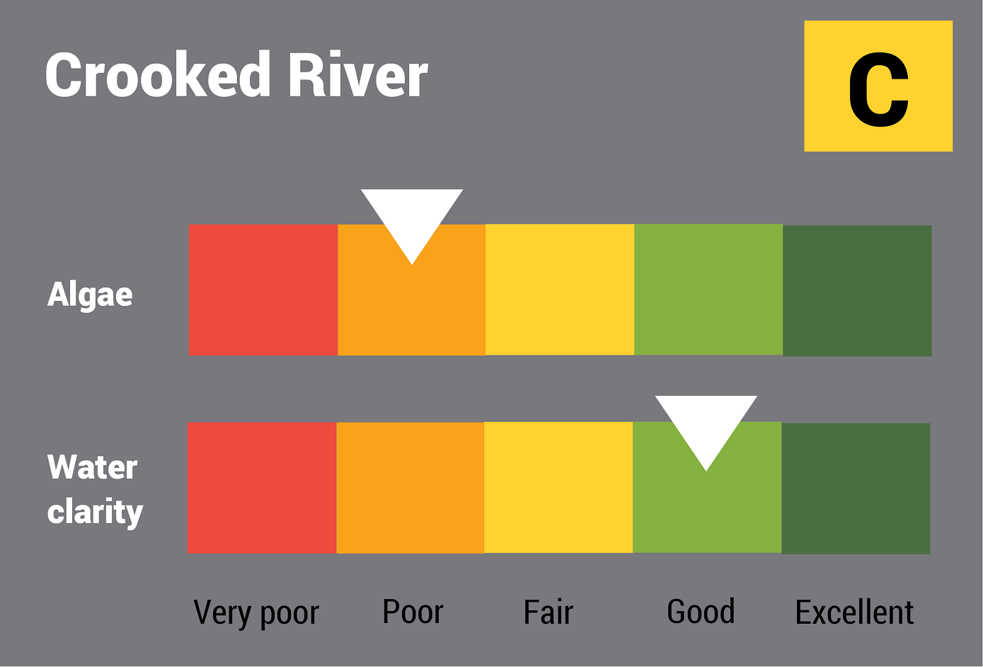
This report card represents 2 water quality indicators that we routinely measure: the amount of algae present and water clarity. Low levels of these 2 indicators equate with good water quality.
The report card shows the condition of the estuary was fair with:
- algae abundance graded poor (D)
- water clarity graded good (B)
- overall estuary health graded fair (C).
Find out more about our estuary report cards and what each grade means. Read our sampling, data analysis and reporting protocols and find out how we calculate these grades.
We have monitored water quality in the Crooked River since 2008. This table shows the water quality grades for this estuary over that time.

Grades for algae, water clarity and overall are represented as:
- A – excellent
- B – good
- C – fair
- D – poor
- E – very poor.
Physical characteristics
Estuary type: Barrier river
| Entrance location |
Latitude (ºS) | –34.77 |
|---|---|---|
| Longitude (ºE) | 150.82 | |
| Catchment area (km2) | 32 | |
| Estuary area (km2) | 0.3 | |
| Estuary volume (ML) | 140.8 | |
| Average depth (m) | 0.5 | |
Water depth and survey data
Bathymetric and coastal topography data for this estuary are available in our data portal.
Land use
The catchment of Crooked River is highly disturbed, with about 75% of land used for grazing and rural residence. Urban land use makes up less than 10% of the catchment at Gerroa and Seven Mile Beach, including two holiday parks. A water recycling plant is also located at Gerroa. Over 10% of the catchment is forested and this includes some of Seven Mile Beach National Park.
National and marine parks
- The largest conservation area in the Crooked River catchment is Seven Mile Beach National Park.
- There is no marine park associated with the Crooked River estuary.
Community involvement
- Landcare Illawarra support volunteer groups working to improve the environment in this region.

Local government management
Local councils manage estuaries within their area unless the estuary is attached to a marine park.
Kiama Municipal Council manages the Crooked River estuary.
 An endangered