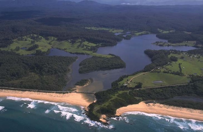
Cuttagee Lake is a small lagoon located on the far south of New South Wales, south of Bermagui. It is classed as a lagoon, with an intermittently closed entrance.
Cuttagee Creek and Buggy Creek are the main tributaries for this estuary.

Our water quality monitoring program has shown Cuttagee Lake to have good water quality. Find out more about the estuary and its unique features.
Cuttagee Lake is a small lagoon located on the far south of New South Wales, south of Bermagui. It is classed as a lagoon, with an intermittently closed entrance.
Cuttagee Creek and Buggy Creek are the main tributaries for this estuary.
As part of our water quality monitoring program we assess the water quality and ecosystem health of an estuary using a range of relevant indicators. We sample a subset of the estuaries between Wollongong and the Victorian border every 3 years. The most recent sampling in Cuttagee Lake was completed over the 2017–18 summer when 2 sites were sampled on a monthly basis.

This report card represents 2 water quality indicators that we routinely measure: the amount of algae present and water clarity. Low levels of these 2 indicators equate with good water quality.
The report card shows the condition of the estuary was good with:
Find out more about our estuary report cards and what each grade means. Read our sampling, data analysis and reporting protocols and find out how we calculate these grades.
We have monitored water quality in the Cuttagee Lake since 2007. This table shows the water quality grades for this estuary over that time.

Grades for algae, water clarity and overall are represented as:
Estuary type: Lagoon
| Entrance location |
Latitude (ºS) | –36.49 |
|---|---|---|
| Longitude (ºE) | 150.06 | |
| Catchment area (km2) | 53.1 | |
| Estuary area (km2) | 1.3 | |
| Estuary volume (ML) | 1130.3 | |
| Average depth (m) | 0.9 | |
Notes: km2 = square kilometres; m = metres; ML = megalitres.
Bathymetric and coastal topography data for this estuary are available in our data portal.
The catchment of Cuttagee Lake has relatively low disturbance with over 90% forest in Biamanga National Park. Urban, rural residence and grazing constitute almost 5% of the land use.
Local councils manage estuaries within their area unless the estuary is attached to a marine park.
Bega Valley Shire Council manage this estuary.
Estuaries provide important breeding, nursery and feeding grounds for many fish and birds.
Read more about the biodiversity in our estuaries.