Terrigal Lagoon

We collaborate with local government to monitor the condition of Terrigal Lagoon. Find out more about the Terrigal Lagoon estuary and its unique features.

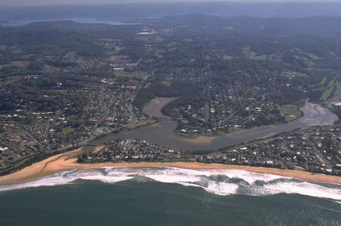
Terrigal Lagoon is situated on the central coast of New South Wales. It is classed as a lagoon with an intermittently closed entrance. The estuary is artificially opened when water height reaches a specific trigger level that threatens residential areas along the foreshore.

Terrigal is one of the most popular destinations on this part of the coast and therefore the estuary faces particular pressure from expanding urban and tourism development.

Estuary health and features

Water quality

As part of our water quality monitoring program we assess the water quality and ecosystem health of an estuary using a range of relevant indicators. We sample 2 sites on a monthly basis over summer in Terrigal Lagoon as part of a collaborative program with Central Coast Council. The most recent sampling was completed over the 2020–21 summer.

The results of the monitoring program, including a detailed water quality report card for Terrigal Lagoon, are available on the Central Coast Council website.

Find out more about our estuary report cards and what each grade means. Read our sampling, data analysis and reporting protocols and find out how we calculate these grades.

As part of our Beachwatch program we assess swimming suitability at 1 swimming site in Terrigal Lagoon using microbial indicators. Central Coast Council collect samples at the site weekly between October and April, and monthly from May to September, to calculate the suitability grade. Sampling is ongoing. The grade reflects the most recent 100 water quality results to April 2022. Find out more about how we monitor beach water quality.

Local government area Swim site name Grade
Central Coast Terrigal Lagoon Poor

Estuarine, lake and lagoon water can sometimes be unsuitable for swimming, especially after rainfall when stormwater and wastewater can overflow into swimming areas. Learn more about what the grades mean and how we grade swimming sites on our beach classification webpage.

Water sampling and laboratory analysis was funded by Central Coast Council.

Physical characteristics

Estuary type: Lagoon

Entrance
location
Latitude (ºS) –33.44
Longitude (ºE) 151.44
Catchment area (km2) 8.9
Estuary area (km2) 0.3
Estuary volume (ML) 151.2
Average depth (m) 0.5
Notes: km2 = square kilometres; m = metres; ML = megalitres.

Water depth and survey data

Bathymetric and coastal topography data for this estuary are available in our data portal.

Land use

The dominant land use within Terrigal Lagoon catchment is urban development catering to residents and tourists. About 10% of the catchment remains forested.

National and marine parks

  • No conservation areas are found within this catchment.
  • This estuary does not flow into a marine park.

Community involvement

Terrigal Lagoon

Local government management

Local councils manage estuaries within their area unless the estuary is attached to a marine park.

Terrigal Lagoon estuary is managed by Central Coast Council. Information about this estuary, including management plans, can be found on the council’s Coastal lagoons webpage.