Wallaga Lake

Our water quality monitoring program has shown Wallaga Lake to have fair water quality. Find out more about the estuary and its unique features.

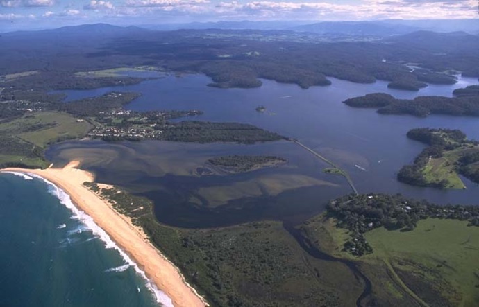
Wallaga Lake is located north of the township of Bermagui on the south coast of New South Wales. It is classed as a lake with an intermittently closed entrance.

Dignams Creek and Narira Creek are 2 major tributaries that feed into the lake. The lake supports great biodiversity, including seagrass beds, swamps, saltmarsh and wetlands.

Wallaga Lake is a popular tourist destination as it provides a host of recreational activities in a well-preserved environment. The lake is commercially fished for finfish, prawns and oysters providing one of the largest commercial catches on the south coast. Meads Bay is a significant area within the estuary as it is a fish nursery.

Estuary health and features

Water quality

As part of our water quality monitoring program we assess the water quality and ecosystem health of an estuary using a range of relevant indicators. We sample a subset of the estuaries between Wollongong and the Victorian border every 3 years. The most recent sampling in Wallaga Lake was completed over the 2021–22 summer when 3 sites were sampled on a monthly basis.

Wallaga Lake water quality report card for algae and water clarity showing colour-coded ratings (red, orange, yellow, light green and dark green, which represent very poor, poor, fair, good and excellent, respectively). Algae is rated 'poor' and water clarity is rated 'fair' giving an overall rating of 'fair' or 'C'.

This report card represents 2 water quality indicators that we routinely measure: the amount of algae present and water clarity. Low levels of these 2 indicators equate with good water quality.

The report card shows the condition of the estuary was fair with:

  • algae abundance graded poor (D)
  • water clarity graded fair (C)
  • overall estuary health graded fair (C).

Find out more about our estuary report cards and what each grade means. Read our sampling, data analysis and reporting protocols and find out how we calculate these grades.

We have monitored water quality in Wallaga Lake since 2008. This table shows the water quality grades for this estuary over that time.

Wallaga Lake historic water quality grades from 2008-09 for algae and water clarity. Colour-coded ratings (red, orange, yellow, light green and dark green represent very poor (E), poor (D), fair (C), good (B) and excellent (A), respectively).

Grades for algae, water clarity and overall are represented as:

  • A – excellent
  • B – good
  • C – fair
  • D – poor
  • E – very poor.

Physical characteristics

Estuary type: Lake

Entrance
location
Latitude (ºS) –36.37
Longitude (ºE) 150.08
Catchment area (km2) 263.8
Estuary area (km2) 9.3
Estuary volume (ML) 33,512
Average depth (m) 3.7

Tidal exchange volume

Tidal exchange volume or tidal prism data is available for this estuary. This data was recorded in 1995.

Tide state Flow
(106 m3)
Local tidal
range (m)
Sydney Harbour
tidal range (m)
Ebb flow 0.4 0.05 1.35
Flood flow 0.38 0.03 1.31
Notes: km2 = square kilometres; m = metres; m3 = cubic metres; ML = megalitres.

Water depth and survey data

Bathymetric and coastal topography data for this estuary are available in our data portal.

Land use

The catchment of Wallaga Lake is moderately disturbed. About 35% of land has been cleared for grazing in the Tilba Tilba and Cobargo region. Over half of the catchment is forested with substantial portions in Gulaga and Kooraban national parks.

National and marine parks

Citizen science projects

Community involvement

Wallaga Lake