Unallocated vegetation clearing includes:
- lawful clearing or vegetation clearing on rural regulated land that does not require an approval, notification and/or keeping of records
- vegetation clearing for which the Department of Climate Change, Energy, the Environment and Water does not have access to information or records that authorise, explain or allocate the clearing to a particular land management activity
- areas of vegetation that have been cleared unlawfully or are not fully compliant with approvals.
How unallocated clearing is identified
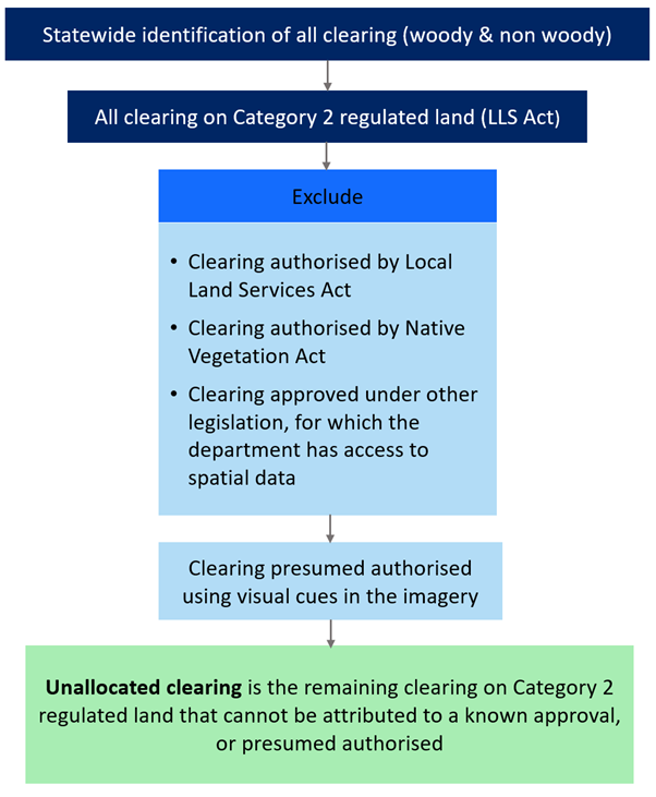
Areas of vegetation clearing detected from satellite imagery are compared with known landcover change that has been approved, such as Land Management (Native Vegetation) Code 2018 notifications, certifications and forestry approvals.
The department is responsible for mapping the clearing of native vegetation and compliance under the Local Land Services Act 2013. Since the introduction of Part 5A of the Local Land Services Act, unallocated clearing has been reported on the rural regulated land part of the state. Land categorised as Category 1 – exempt does not require any approval.
Clearing of native vegetation in other parts of the state, such as urban areas and land zoned for environmental protection, is regulated under the State Environmental Planning Policy (Biodiversity & Conservation) 2021, formerly State Environmental Planning Policy (Vegetation in Non-Rural Areas) 2017. Local councils usually provide authorisations for clearing on these areas.
The department applies a process of elimination to clearing on rural regulated land to identify unallocated clearing. Unallocated clearing is identified by excluding authorised clearing from all the detected clearing on rural regulated land and using visual cues in the imagery to allocate clearing events to presumed authorised activities. For example, clearing events likely to be presumed allowable activities under the Local Land Services Act, such as long straight lines along fences, farm tracks or around farm buildings, can be determined using visual cues. However, no analysis of the characteristics of these activities have been undertaken to ensure they align with the specifications under the Act.
What happens to areas of unallocated clearing?
The department applies a risk management approach to unallocated clearing that considers the area of vegetation change on a property, the nature of the vegetation impacted and the potential sources of clearing authorisation that are not spatially recorded or are only available to the government on request.
The Local Land Services Act includes low-risk routine farming activities called allowable activities that support maintaining infrastructure and other day-to-day activities required to run a farming enterprise. Some areas of lawful clearing can only be determined if a landholder provides additional information, such as information about the history of land management or application of allowable activities.
Areas of clearing that cannot be explained may be investigated further by a compliance team. All investigations are undertaken in accordance with department compliance policies. If unlawful clearing is found, the department will select an appropriate outcome based on environmental, social and regulatory considerations. All significant outcomes are reviewed by an expert advisory committee.
Why can't areas of unallocated clearing be identified as authorised?
Not all clearing has an approval record that can be matched against clearing identified from satellite imagery.
A proportion of the unallocated non woody clearing would be associated with landholder self-assessment of groundcover categorisation. The landholder is required to keep appropriate records of this self-assessment.
Unallocated clearing may also be associated with landholder use of allowable activity provisions, where no prior authorisation is required to manage vegetation for routine farm management activities. These provisions are undertaken at the discretion of the landholder, but do have to meet certain prescriptions.
Landholders are not required to keep records or tell government departments when they are undertaking an allowable activity. However, Local Land Services is required to publicly report annually on estimated rates of clearing resulting from allowable activities.
Under Part 4 (Continuing Use) in the Land Management Code, clearing of some native vegetation regrown since 1990 can be undertaken without needing to notify Local Land Services or obtain a certificate. As a result, no records can be used to explain detected clearing of regrowth.