
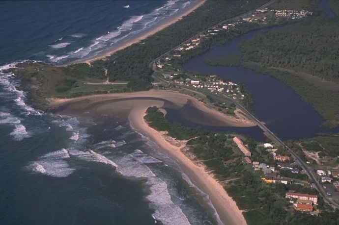
Cudgera Creek is a barrier river estuary near Pottsville on the New South Wales north coast and meets the sea at Hastings Point. The entrance is untrained, meaning it can become very constricted and can close to the ocean at certain times.
Cudgera Creek
Our water quality monitoring program has shown Cudgera Creek to have poor water quality. Find out more about the estuary and its unique features.
Water quality
As part of our water quality monitoring program we assess the water quality and ecosystem health of an estuary using a range of relevant indicators. We sample a subset of the estuaries located between the Queensland border and Taree every 3 years. The most recent sampling in Cudgera Creek was completed over the 2015–16 summer when 2 sites were sampled on a monthly basis.

This report card represents 2 water quality indicators that we routinely measure: the amount of algae present and water clarity. Low levels of these 2 indicators equate with good water quality.
The report card shows the condition of the estuary was poor with:
- algae abundance very poor (E)
- water clarity graded fair (C)
- overall estuary health graded poor (D).
Find out more about our estuary report cards and what each grade means. Read our sampling, data analysis and reporting protocols and find out how we calculate these grades.
We have monitored water quality in the Cudgera Creek since 2012. This table shows the water quality grades for this estuary over that time.
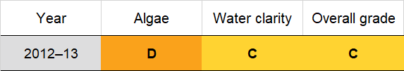
Grades for algae, water clarity and overall are represented as:
- A – excellent
- B – good
- C – fair
- D – poor
- E – very poor.
Physical characteristics
Estuary type: Barrier river
| Entrance location |
Latitude (ºS) | –28.36 |
|---|---|---|
| Longitude (ºE) | 153.58 | |
| Catchment area (km2) | 60.5 | |
| Estuary area (km2) | 0.5 | |
| Estuary volume (ML) | 250.1 | |
| Average depth (m) | 0.6 | |
Water depth and survey data
Bathymetric and coastal topography data for this estuary are available in our data portal.
Land use
The catchment of Cudgera Creek is highly disturbed, with around 60% of land use being changed. A mix of grazing, agriculture and horticulture dominate the catchment. Urban areas account for around 12% of land use. The towns of Pottsville and Hastings Point are located along the estuary.
National and marine parks
- Three conservation areas in the Cudgera Creek catchment are Mooball National Park, Cudgera Creek Nature Reserve and Cudgen Nature Reserve.
- This estuary does not flow into a marine park.
Community involvement
- Pottsville Environmental Park is a 54-hectare park of coastal vegetation between the two arms of Cudgera Creek. Set aside by the local council, the park is aimed at school and environmental group excursions.
Local government management
Local councils manage estuaries within their area unless the estuary is attached to a marine park. Tweed Shire Council manage this estuary.
 Threatened species, such as the