Towamba River

Our water quality monitoring program has shown the Towamba River estuary to have excellent water quality. Find out more about the estuary and its unique features.

Towamba River is located on the far south coast of New South Wales. It is classed as a barrier river estuary and enters Twofold Bay via a permanently open entrance.

The Towamba River is the largest coastal river in the region and flows for 86 kilometres from the Great Dividing Range to the sea. It is dominated by smaller intermittently closed/open lakes and lagoons.

Estuary health and features

Water quality

As part of our water quality monitoring program we assess the water quality and ecosystem health of an estuary using a range of relevant indicators. We sample a subset of the estuaries between Wollongong and the Victorian border every 3 years. The most recent sampling in the Towamba River was completed over the 2008–09 summer when 2 sites were sampled on a monthly basis.

Towamba River water quality report card for algae and water clarity showing colour-coded ratings (red, orange, yellow, light green and dark green, which represent very poor, poor, fair, good and excellent, respectively). Algae is rated 'excellent' and water clarity is rated 'excellent' giving an overall rating of 'excellent' or 'A'.

This report card represents 2 water quality indicators that we routinely measure: the amount of algae present and water clarity. Low levels of these 2 indicators equate with good water quality.

The report card shows the condition of the estuary was excellent with:

  • algae abundance graded good (B)
  • water clarity graded excellent (A)
  • overall estuary health graded excellent (A).

Find out more about our estuary report cards and what each grade means. Read our sampling, data analysis and reporting protocols and find out how we calculate these grades.

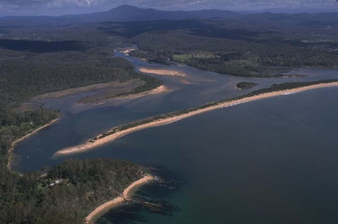
Physical characteristics

Estuary type: Barrier river

Entrance
location
Latitude (ºS) –37.11
Longitude (ºE) 149.91
Catchment area (km2) 1026.2
Estuary area (km2) 2
Estuary volume (ML) 2050.4
Average depth (m) 1.1
Notes: km2 = square kilometres; m = metres; ML = megalitres.  

Water depth and survey data

Bathymetric and coastal topography data for this estuary are available in our data portal.

Land use

The large catchment of Towamba River is predominantly forested as part of the South East Forests National Park and managed by Forestry Corporation. About 15% of the catchment is cleared for grazing and rural residence, mainly concentrated around the riverine valleys and towns of Towamba and Wyndham. There are also a small number of horticultural properties within the catchment.

Water use

Find out about water use in the Towamba River, including information about major water users, real-time flow data, and environmental and water sharing plans.

National and marine parks

Citizen science projects

  • The Far South Coast Conservation Management Network supports the local community to better manage native biodiversity. The network organises citizen science projects, provides information for private landowners, manages a local plant database, and coordinates events.

Community involvement

Towamba River

Local government management

Local councils manage estuaries within their area unless the estuary is attached to a marine park. Bega Valley Shire Council manage this estuary.