Wallis Lake

We collaborate with local government to monitor the condition of Wallis Lake and its inflowing waterways. Find out more about the Wallis Lake estuary and its unique features.

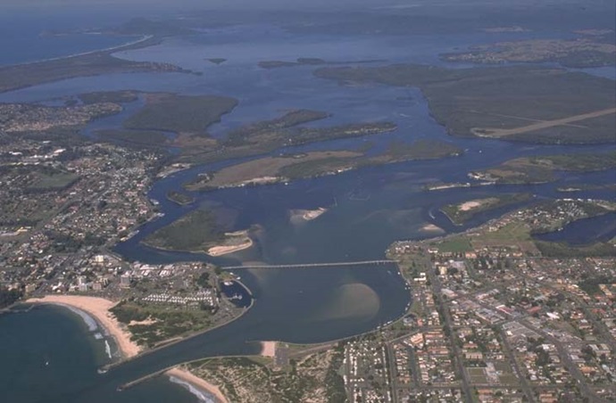
The Wallis Lake is located on the mid-north coast of New South Wales and flows into the sea between the towns of Forster and Tuncurry. It is classed as a lake and has a large trained entrance that is permanently open to the sea.

Wallis Lake receives waters from a number of inflowing streams and rivers, including the Coolongolook, Wallingat, Wang Wauk and Wallamba rivers, Pipers Creek and Wallamba Cove.

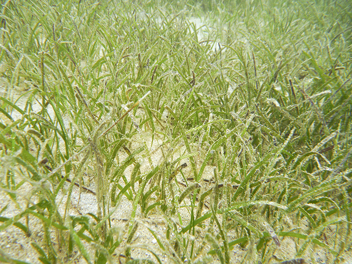
The lake and the lower parts of the inflowing rivers support extensive seagrass beds, saltmarsh and mangrove communities. The seagrass beds here make up about one-fifth of the total seagrasses in New South Wales. Its wetlands are listed as nationally important.

Wallis Lake produces 80% of the state’s commercial crabs and is one of the most significant producers of Sydney rock oysters in Australia.

Estuary health and features

Water quality

As part of our water quality monitoring program we assess the water quality and ecosystem health of an estuary using a range of relevant indicators. We sample 3 sites on a monthly basis over summer in Wallis Lake and 2 sites in Wallamba River, Wallamba Cove, Pipers Creek and Coolongolook River as part of a collaborative program with Mid Coast Council. The most recent sampling was completed over the 2021–22 summer.

The results of the monitoring program, including a detailed water quality report card for the inflowing tributaries, are available on the Mid Coast Council website.

Find out more about our estuary report cards and what each grade means. Read our sampling, data analysis and reporting protocols and find out how we calculate these grades.

Physical characteristics

Estuary type: Lake

Entrance
location
Latitude (ºS) –32.17
Longitude (ºE) 152.51
Catchment area (km2) 1196.9
Estuary area (km2) 98.7
Estuary volume (ML) 217,951.5
Average depth (m) 2.3

Tidal exchange volume

Tidal exchange volume or tidal prism data is available for this estuary. This tidal prism was measured in 1998.

Tide state Flow
(106 m3)
Local tidal
range (m)
Sydney Harbour
tidal range (m)
Ebb flow 13.8 1.41
1.69
Flood flow 16.6 1.34
1.66
Notes: km2 = square kilometres; m = metres; m3 = cubic metres; ML = megalitres.

Water depth and survey data

Bathymetric and coastal topography data for this estuary are available in our data portal.

Land use

The catchment immediately surrounding Wallis Lake remains mostly forested but is interrupted by urban development including the towns of Forster and Tuncurry. Further up the river valleys, agriculture and rural-residential development has led to significant clearing and land use changes. Over half of the catchment remains as forest.

Web cam

The Forster bar crossing web camera provides real-time video of conditions within the river entrance immediately offshore to help with bar crossings and boat safety.

National and marine parks

  • Wallingat National Park is the largest conservation area in this catchment.
  • This estuary does not flow into a marine park.

Community involvement

Local government management

Local councils manage estuaries within their area unless the estuary is attached to a marine park.

Mid Coast Council manage this estuary. Information about Wallis Lake estuary and its tributaries, including water quality report cards, can be found on the council’s Wallis Lake webpage.