New biodiversity measures for better management

Our scientists have developed a new way to assess, monitor and measure the health of our ecosystems over time. This will inform on-ground management and policies that help protect our biodiversity.

Cumberland Plain Woodland in the Sydney Basin Bioregion and understorey of Bursaria spinosa or Native blackthornNew South Wales has a huge diversity of incredible plants, animals and ecosystems, collectively known as ‘biodiversity’.

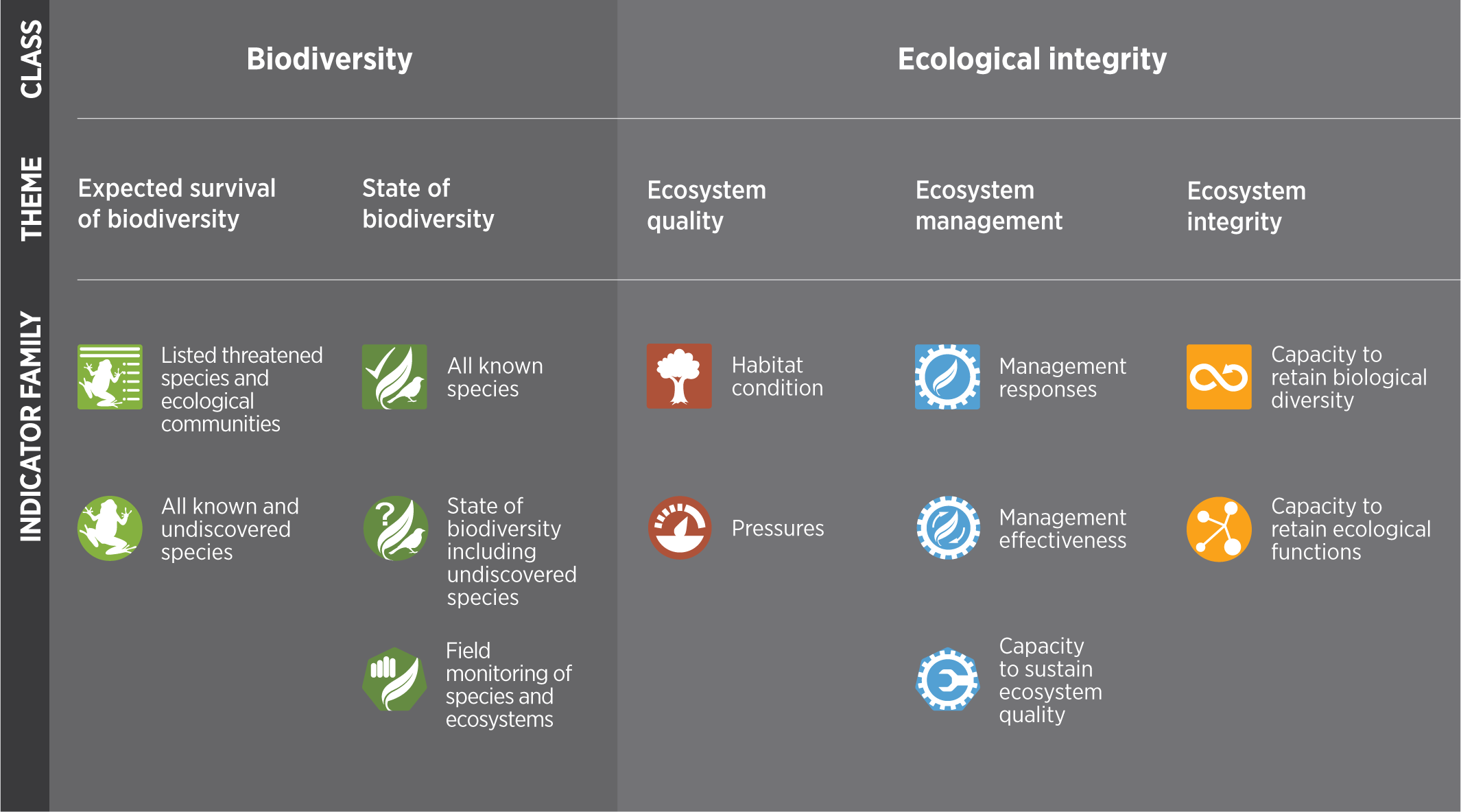
High biodiversity indicates a healthy ecosystem. Understanding the status of biodiversity, and how it’s changing, is important to be able to protect and manage it into the future.

The challenge

We need to manage and protect our biodiversity. To do this, policymakers, business owners and communities all need relevant and accurate measures so they can make good decisions and direct resources appropriately.

To feed into policy and legislative requirements, such as reporting under the Biodiversity Conservation Act 2016, our scientists look at:

  • at risk ecosystems and species
  • locations that need the most management, such as key habitat areas or more likely to be disturbed
  • actions that could be taken to protect or rehabilitate
  • whether conservation efforts are working.

Our scientists began working on a new suite of indicators to measure biodiversity and ecological integrity in 2016. That is, they wanted to know how healthy and robust, or able to recover from disturbances, our ecosystems are.

The aim was to develop monitoring methods that were:

  • accurate
  • easy to understand, and
  • able to gather data consistently over time.

The team collaborated with experts from CSIRO, the Australian Museum, University of Queensland, Queensland University of Technology and Macquarie University.

Our scientists reviewed dozens of potential indicators through this work. They incorporated policy requirements as well as the best available scientific knowledge.

They created a new framework, identifying 30 specific indicators, which are grouped under 5 themes. The detailed method behind this project documents how the indicators are to be measured and how the data informing them are to be collected.

Diagram showing the hierarchy of classes, themes and indicator families in the Biodiversity Indicator Program

Results of the first assessments that used the indicators were published in 2020. The NSW Biodiversity Outlook Report and a ‘report card’ for each indicator effectively produced a new baseline for the state of our biodiversity and ecosystems.

The new suite of indicators is now:

  • part of regular reporting processes, such as the NSW State of the Environment Reports
  • published and publicly available on our Sharing and Enabling Environmental Data portal
  • regularly used by the research community
  • used at the regional- and state-scale by government, for example in strategic planning.

Other state and Commonwealth government agencies are considering adopting similar approaches.

Hot tip: Which data is proving most popular so far? According to David Nipperess, one of our senior scientists, it’s information about habitat condition. “This is probably because the maps show how intact habitat is at a high resolution across the state and can be easily compared to other spatial information such as the known range of a threatened species,” explained David.

Establishing biodiversity baselines has been crucial for conservation and environmental management teams. Our researchers will continue to gather data, report on biodiversity, and make their results publicly available.

Internationally, scientists are enthusiastically watching the roll-out and future development of NSW’s biodiversity reporting.

Map of New South Wales showing general quality or ecological condition of habitat for biodiversity across the state. Dark orange or ‘low’ indicates habitat has been completely removed, whereas dark teal or ‘high’ indicates habitat is intact relative to a pre-industrial state.