Science and Economics and Insights Division in the Department of Climate Change, Energy, the Environment and Water generates statewide woody and non woody vegetation clearing data for annual landcover monitoring and reporting.
Non woody clearing data has been captured from 2017, data on woody vegetation clearing is available from 1988. Information on the method used to detect woody vegetation clearing is documented in Statewide Landcover and Tree Study: woody vegetation.
Non woody vegetation clearing is detected by identifying repeated disturbance to grasses, small shrubs and groundcover resulting from cyclical land management practices within a 12-month period. This repeated disturbance results in clearing or permanent change to the land cover, for example, from undisturbed grassland to cropping. Clearing is only monitored in non woody vegetation where repeated disturbance or clearing has not been detected since 1990.
Applying the Statewide Landcover and Tree Study (SLATS), clearing is captured by interpreters comparing 2 high-resolution satellite images and identifying changes using monthly images, ancillary data and time series imagery products.

Satellite images from left to right showing before and after clearing for cropping. The left image shows consistent colour inside and outside the blue polygon suggesting undisturbed grassland, whereas clear striations and a change in colour in the right-side image indicate transition to cropping.
How we detect non woody vegetation clearing
We use a combination of manual and automated mapping techniques to monitor non woody vegetation clearing.
The Statewide Landcover and Tree Study method is applied using imagery from the European Space Agency's Sentinel-2A and Sentinel-2B, Planet and SPOT 6/7 satellites that capture high-resolution images of the Earth's surface.
Non woody clearing is only monitored in undisturbed grasslands, that is, where repeated disturbance or clearing has not been detected since 1990. State forests and national parks are excluded from the analysis.
The Statewide Landcover and Tree Study method for non woody clearing is documented in the Native Vegetation Regulatory Map Method and was independently peer-reviewed before publication in October 2021.
Method
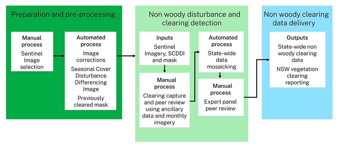
Workflow diagram and description
Preparation and pre-processing
Sentinel-2 satellite images are selected as close as possible to 1 January each year. The images must have a clear view of the ground and not be impacted by smoke or cloud cover.
Images then go through a series of automated corrections.
A raster layer, the Seasonal Cover Disturbance Difference Image (SCDDI), is automatically generated from a series of images from 1988 to the current reporting year.
The Seasonal Cover Disturbance Difference Image identifies areas of landcover disturbance in the landscape by analysing reflectance patterns over time. This is used as an ancillary dataset to assist with identifying areas of potential non woody clearing for closer analysis against high-resolution imagery.
A mask is created of areas previously identified as cleared from 1990 to the current reporting year. This prevents recording clearing in areas that have been captured and reported on.
Non woody disturbance and clearing detection
The imagery and datasets are packaged for delivery to imagery interpreters for review.
A visual assessment is done at a scale of 1:20,000 across the state using pre and post-sentinel imagery sources and the Seasonal Cover Disturbance Difference Image. Additional ancillary datasets and monthly imagery assists with interpretation. Where clearing is identified, it is captured and mapped at a scale of 1:10,000 (or finer scale).
Areas that are recognised by an editor as cleared are assigned a replacement landcover class, to indicate the purpose for which the vegetation was cleared. The assignment of these classes is primarily based on visual interpretation. This involves investigating the context of the identified clearing event in the imagery with reference to ancillary data sources.
In areas with many different forms of land use, it can be sometimes difficult to interpret the final landcover class; therefore, this classification is indicative only.
The landcover classes are:
- agriculture, such as clearing for grazing (sown exotic pastures), cropping or horticulture
- infrastructure, such as residential, commercial, mining and farm infrastructure
- forestry, such as native and plantation harvesting, establishment, thinning, forestry infrastructure.
When a non woody clearing event is detected, it is mapped and then peer-reviewed by a second imagery interpretation expert.
All the captured polygons are collated into a single statewide layer, and subject to a series of automated checks for geospatial, topological or attribution errors, with any anomalies resolved by interpreters. A panel of experts then reviews this final layer for consistency and final validation.
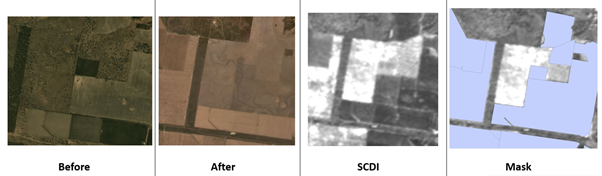
Satellite and SCDDI images from left to right showing before and after non woody clearing for agriculture with the SCDDI predicting high levels of disturbance in white and previously identified cleared areas masked out in blue.
Multidate imagery analysis of non woody clearing
The conversion of undisturbed grasslands to cropping can often be seen clearly in imagery when comparing 2 images approximately 12 months apart.
A distinct change in pattern in the image associated with the use of machinery to turn the soil and plant a crop or monoculture, within a defined land management boundary can be identified by interpreters.
Since capturing non woody clearing in 2017, approximately 70% of clearing events each year are attributed to cropping.
Conversion of undisturbed grasslands to sown exotic pastures using a management cycle of spraying and sowing (including tillage) over long periods can be more difficult to detect. These events may be picked up in the first year of imagery analysis but require multiple images from that year to detect the sequence of events.
This sequence of events may sometimes extend over a calendar year, requiring additional imagery in the following 12 months to confirm the clearing event. The clearing event is assigned to the calendar year in which the sequence of events commenced. This results in preliminary annual non woody clearing figures until confirmed in the next annual report.

Satellite imagery from left to right showing January 2021 undisturbed grassland. July 2021 and September 2021 showing incremental change resulting from spraying, tilling and sowing events, followed by the green flush of exotic pastures confirming a non woody clearing event in January 2022. The clearing event was assigned to the 2021 reporting year as the sequence of management actions commences in that year.
Non woody clearing data delivery
The non woody clearing data is then delivered as a statewide GeoTIFF raster via the Sharing and Enabling Environmental Data portal.
The data is combined with the Statewide Landcover and Tree Study (SLATS) woody clearing data for statistical analysis for annual vegetation clearing reporting. Vegetation clearing reports are available from Landcover science below.
Products
Current and historical non vegetation clearing data will is available through the Sharing and Enabling Environmental Data portal after any compliance investigations have been completed.