A year in the Border Rivers catchment: 2022-23

Outcomes from the use of water for the environment.

Natural rainfall and dam spills achieved a range of ecological outcomes in the Border Rivers system in 2022–23.

Key outcomes

Under wet to very wet conditions, significant flows in the catchment met environmental demands, resulting in:

  • continuous connection to the Barwon River for the whole year
  • multiple flow events in the Boomi River across a range of flow categories, including small and large freshes, bankfull and overbank events
  • inundation of large areas of the floodplain
  • summer flows in Morella Watercourse.

Map of Border Rivers catchment. Natural rainfall and flooding provided for the environmental demand and no environmental water deliveries were made in the 2022-23 water year.

Catchment conditions

During 2022–23, weather patterns in the Border Rivers region were driven by various climate conditions including a strong La Niña event. This resulted in high rainfall and moderate temperatures, with significant flows throughout the system as major dams reached and exceeded storage capacity.

Higher than average flows and significant floodplain inundation occurred through the catchment, meeting instream and floodplain environmental demands and negating the need to deliver water for the environment throughout the water year.
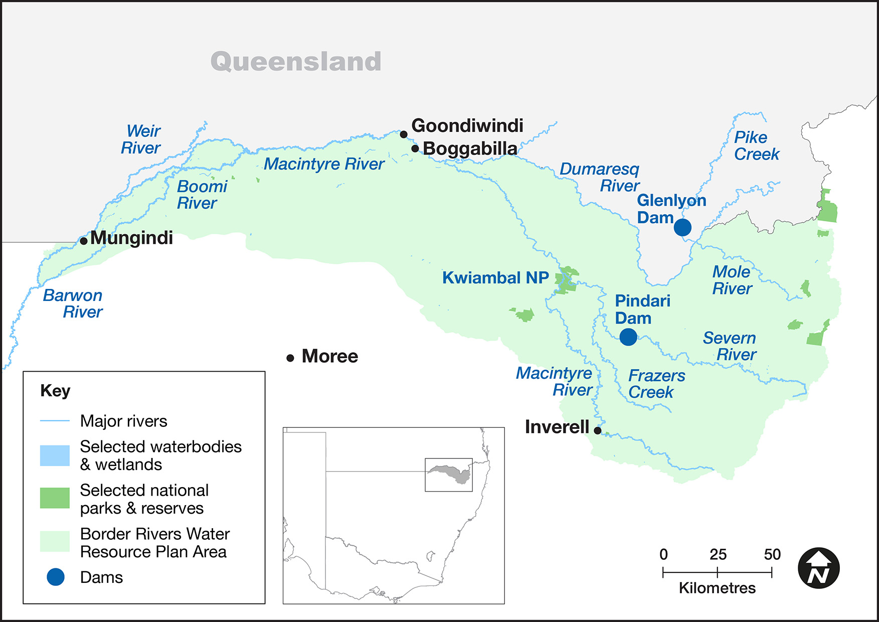
About the catchment

The Border Rivers catchment hugs the NSW–Queensland border in north-east NSW and covers an area of 24,000 square kilometres. Located in a temperate and sub-tropical climatic zone, rainfall is typically summer dominant with an annual average rainfall of 620 millimetres at Goondiwindi.

The major tributaries of the catchment are the Macintyre, Severn, Dumaresq and Weir rivers and Macintyre Brook, becoming the Barwon River near Mungindi. The Border Rivers catchment has 2 major water storages – the Pindari Dam on the Severn River in NSW, and Glenlyon Dam on Pike Creek in Queensland.

The Morella Watercourse, including Boobera and Pungbougal lagoons, are located on the Macintyre River floodplain and are important cultural sites for Aboriginal people. These wetlands are also listed as wetlands of national significance.

Water for Country

The Border Rivers catchment is Country to the Bigambul, Euahlayi, Githabul, Kambuwal, Gamilaraay/Gomeroi/Kamilaroi, Kwiambul, and Ngarabal Aboriginal peoples.

Water for Country is environmental water use planned by the Department of Planning and Environment \and Aboriginal people to achieve shared benefits for the environment and cultural places, values and/ or interests. In the 2022–23 water year in the Border Rivers catchment, environmental water managers did not deliver water for the environment due to significant rainfall, flows and dam spills.

Boobera Lagoon is situated to the south-west of Goondiwindi on the Macintyre River floodplain along Morella Watercourse. The lagoon (along with others on this watercourse) has significant Aboriginal heritage value. The Gamilaraay (Kamilaroi) people believe Boobera Lagoon is the resting place of Garriya (rainbow serpent). The site is estimated to contain millions of stone artefacts as well as scar and canoe trees.

The floodplain around Boobera Lagoon observed significant rainfall and flows through October 2022. The Morella Watercourse, including Boobera Lagoon, was connected to the wider Macintyre floodplain around some of these high flow events, with the largest occurring in late October. Water dried off the floodplain through November, with isolated areas remaining into early December.

The Annual environmental water priorities in the Border Rivers catchment 2022–23 were developed under a predicted wet to very wet resource-availability scenario. Aims for the use of water for the environment were to respond to or enhance natural events for the benefit of:

  • native fish populations in the Severn, Dumaresq, Macintyre and upper Barwon rivers
  • deliver flows for fish breeding, recruitment, and connectivity.

Water managers had planned to deliver a small fresh to support native fish, but they did not need to complete the deliveries because of natural flows. The resulting rainfall and natural flows:

  • improved and maintained ecological health and resilience
  • restored and maintained key floodplain and wetland linkages
  • provided opportunities for plants and animals to breed, move and thrive throughout the catchment.

This year no managed deliveries of water for the environment were made. Significant flows were observed throughout the catchment in both regulated and unregulated watercourses.

The Pindari Stimulus flow was triggered for use but was not delivered because natural flows negated its need. The Pindari translucency rule provided flows all year. The Pindari Dam was full and all inflows were passed downstream for the first 6 months of the water year.

Rivers and catchments complete cycles of change at many scales in their shape and habitat characteristics. The most observable changes are the progressive change from wet times to drought and the very rapid change that can occur during a floodplain inundation event.

Although these high flows are significant events, bankfull and smaller events are critical to the functioning of the system’s ecology. Environmental watering targets have been developed for the catchment through the NSW Border Rivers Long-Term Water Plan. Analysis of these targets has shown the vast majority of these have been met. However, the after-effects of the recent drought have impacted the ability to meet all targets completely. A small fresh is required annually (with ideal timing) at Goondiwindi to meet some ecosystem function, fish population and within-bank vegetation needs. Missing this annual event compromises the health, resilience and structure of populations and communities.

Some highlights from this year include wide-scale floodplain inundation, flows in Morella Watercourse and Boomi River, and many opportunities for aquatic and floodplain species to complete all or part of their life cycles. We have seen germination and seedling growth of notable species including coolabah, river red gum and lignum. Several species of frog have completed their lifecycles, such as barking marsh, salmon-striped and broad-palmed frogs.

Large flows critical to the natural cycling of rivers and floodplains

Macintyre River and Barden Lagoon with other floodplain lagoons and watercourses on Macintyre Floodplain near Twin Rivers

From early 2021 to the end of 2022, widespread large-scale change resulted from high-velocity flows and floodplain inundation. This was in contrast to the previous 8 years of low to moderate flows where generally smaller more gradual changes were observed with riverbanks and benches remaining stable, accumulating vegetation and then some loss during drought.

During this recent wet period, many rivers had within-bank benches turned over, moved and cleaned of leaf litter, grasses, shrubs and in some cases small trees. Some benches maintained part of their vegetation, which resulted in accumulation of trees and branches from flood flows.

Although these larger flows and floodplain inundation events can affect local communities and infrastructure, they are critical to the natural cycling of rivers and the ecosystems they support. These events can ‘reset’ the landscape and provide regeneration and regrowth opportunities for different communities and food web assemblages.

The effect of these events varies. Some areas undergo an immediate change and positive response, whereas others have a slower less obvious response. For example, the Macintyre floodplain vegetation and flood-reliant species grew and completed their life cycles, whereas within-bank vegetation was stripped in many places. Suitable species are starting to recolonise these bare bars and banks.

The impacts of current land and water management as well as historical practices and events are evident. Some older members talk of the water quality being vastly different to today – for example, near Mungindi water was clear most of the time – and some places have ongoing bed and bank erosion.

Environmental water managers are doing what they can to support and improve the resilience of remaining native species and communities such as instream aquatic vegetation communities and native fish species. This includes working with other agencies and the community to minimise further damage.

Contact us

Department of Planning and Environment