A year in the Murrumbidgee catchment: 2022-23

Outcomes from the use of water for the environment.

Waterbird breeding, native fish movement and endangered frogs were the focus of managed environmental flows in 2022–23.

Key outcomes

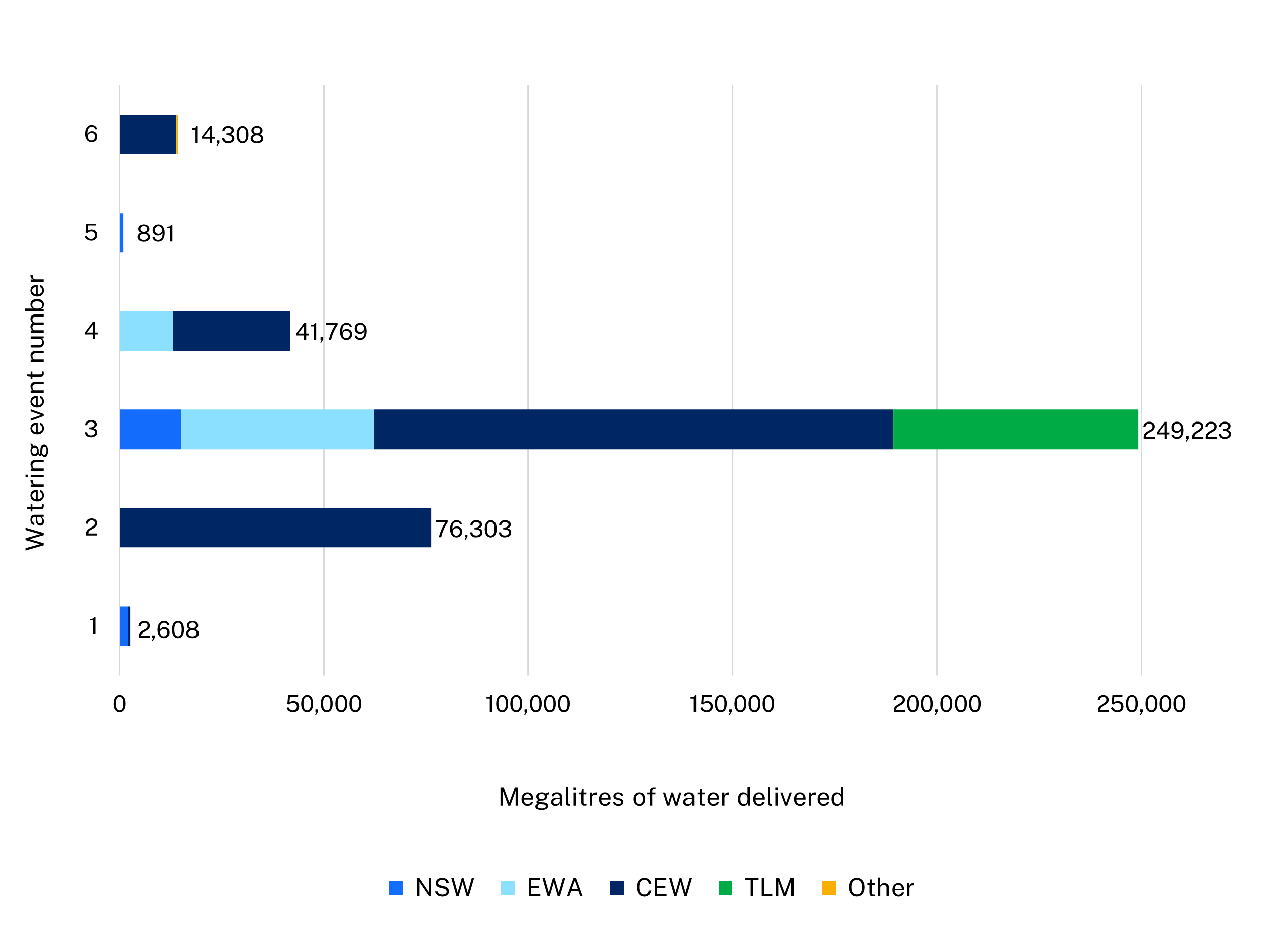
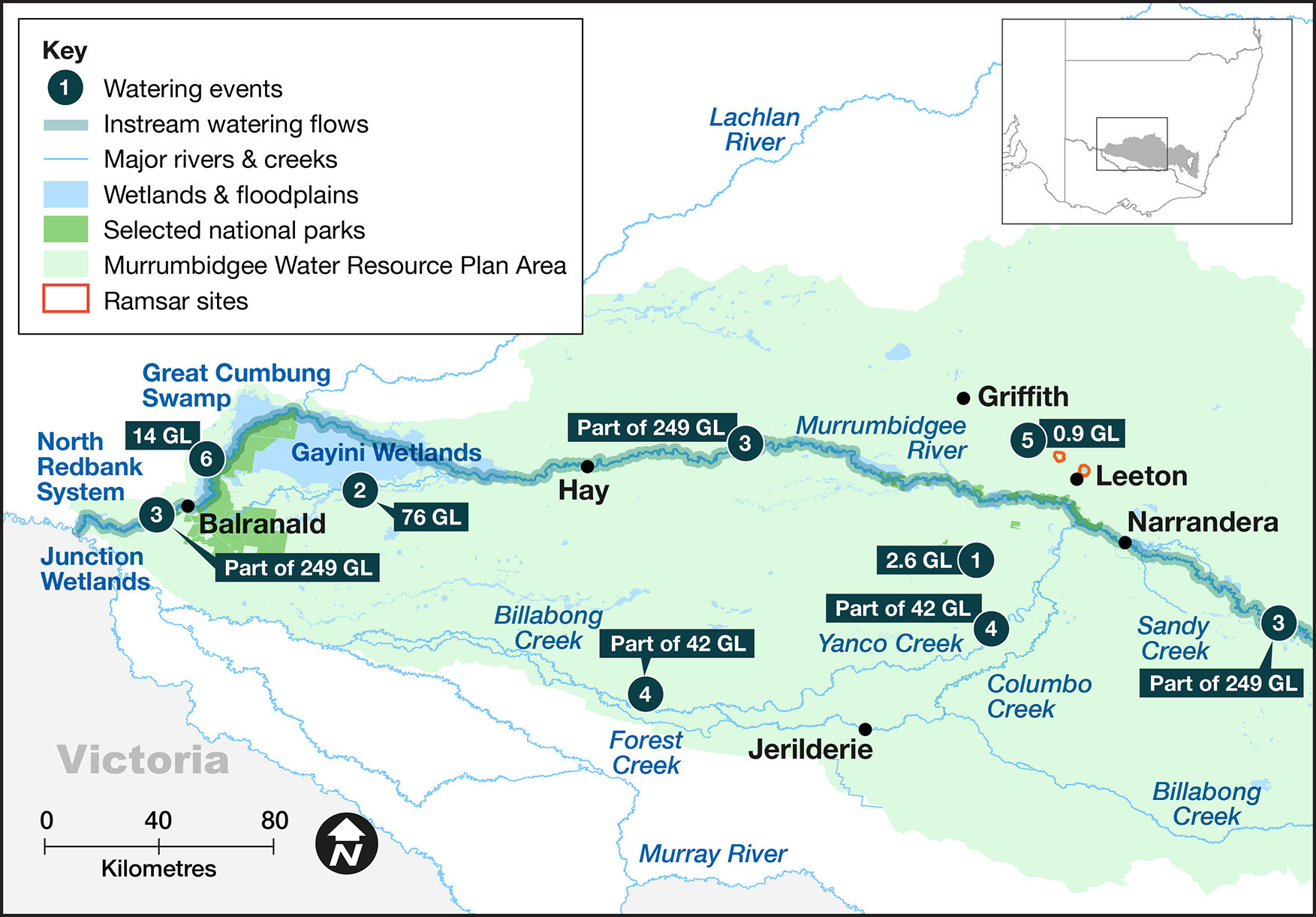
Under very wet conditions, environmental water managers worked with partner agencies and stakeholders to coordinate the delivery of water for the environment to:

  • support a pelican rookery of about 28,000 nests in the Gayini (Nimmie-Caira) wetlands
  • maintain a highly significant ibis and spoonbill rookery of about 100,000 nests in the Gayini (Nimmie-Caira) wetlands
  • increase the distribution of the endangered southern bell frog and Australasian bittern in the Lowbidgee floodplain and Coleambally Irrigation Area
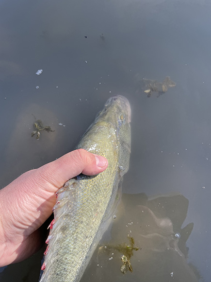
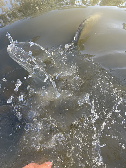
  • protect native fish populations from the risk of hypoxic blackwater conditions in summer and avoid fish deaths in the lower Murrumbidgee and mid-Yanco billabong systems
  • improve fish movement opportunities by managing more gradual and natural flow recession behind large operational releases, as well as minimise riverbank erosion.

Map of sites in the Murrumbidgee catchment where environmental water was delivered in the 2022-23 water year, with corresponding volumes.

Catchment conditions

During the 2022–23 year, the Murrumbidgee catchment experienced La Niña weather conditions resulting in above average rainfall and below average temperatures.

The high rainfall resulted in major flooding throughout the catchment and general and high security licences being 100% allocated. Supplementary water was also accessed during unregulated flow events and the release of water from dams to create airspace.

These circumstances created ideal conditions for native fish movement between floodplain, river, and creek environments. The numerous overbank inundation events in the Lowbidgee floodplain combined seamlessly with ongoing environmental water diversions to create ideal conditions for colonial waterbird breeding.

About the catchment

The Murrumbidgee catchment is in southern NSW and covers an area of 81,527 square kilometres.

Climatic conditions range from alpine in the Snowy Mountains to semi-arid on the Riverina plains.

Major rivers are the Murrumbidgee, with connection flowing into the Murray River and occasionally the Lachlan catchment (Great Cumbung area) when both systems are experiencing high flows.

The Murrumbidgee catchment has 26 storage or diversion structures and 1,690 kilometres of river and surrounding wetlands.

Water for Country

The Murrumbidgee catchment is Country to the Barapa Barapa, Mutthi Mutthi, Nari Nari, Ngarigo, Ngunnawal, Nyeri Nyeri, Wadi Wadi, Wolgalu, Wamba Wamba, Weki Weki and Wiradjuri Aboriginal peoples.

Water for Country is environmental water use planned by the Department of Planning and Environment and Aboriginal people to achieve shared benefits for the environment and cultural places, values and/or interests.

In the 2022–23 water year in the Murrumbidgee, environmental water managers:

  • worked collaboratively with Nari Nari Tribal Council to deliver cultural and environmental outcomes throughout the Gayini wetlands through post-flooding deliveries of water for the environment
  • started to build relationships with Wiradjuri and Mutthi Mutthi Nations through on Country meetings
  • observed that wetlands and floodplains were revitalised by the floods, with box trees brought back to life and an abundance of old man weed and nardoo
  • avoided fish kills in the Lower Murrumbidgee River following environmental flow recession management, which was a significant cultural and ecological outcome.

Under a wet to very wet resource availability scenario, the Murrumbidgee Environmental Water Advisory Group developed its Annual environmental water priorities in the Murrumbidgee catchment 2022–23.

Objectives for the use of water for the environment were to:

  • provide foraging and breeding habitat for waterbirds in the Lowbidgee
  • pump water into key mid-Murrumbidgee and mid-Yanco–Billabong wetlands
  • restore a more natural flow pattern to support native fish populations
  • increase connectivity with mid-Murrumbidgee wetlands and Lowbidgee lakes and maximising fish passage by managing rates of recession, post-airspace releases or tributary flows.

With very wet conditions, environmental water managers used adaptive management strategies to avoid catastrophic events (hypoxic fish deaths), maintain river functions and enhance opportunities for plants and animals to breed, move and thrive.

High flow conditions peaked at moderate to major flood levels along the Murrumbidgee River and Yanco–Billabong Creek systems and above average flows were ongoing throughout the year due to above average rainfall. The floodplain wetlands of Yanga, North Redbank and the mid-Murrumbidgee were adequately watered without environmental water use. The Gayini (Nimmie-Caira) wetlands and the Western Lakes were the only Lowbidgee floodplain systems that required water for the environment.

This table and chart provide a summary of 385,102 megalitres of water for the environment delivered in the Murrumbidgee catchment during the 2022–23 watering year.

Figures were accurate at the date of publishing, but may be adjusted. Watering event numbers in the table and bar chart relate to location numbers marked on the map.

Bar chart showing water delivery to the Murrumbidgee catchment in the 2022-23 water year.

Notes: CEW = Commonwealth licensed environmental water; EWA = environmental water allowance accrued under the water sharing plan; NSW = NSW licensed environmental water; Other = landholder; TLM = The Living Murray.

Watering event number Location Outcomes Start
date
Finish
date
1 Coleambally Irrigation Area Wetlands
Flow-dependent native vegetation icon 06 Dec 2022 10 Oct 2023
2 Gayini Nimmie-Caira Flow-dependent native vegetation icon Waterbird icon 17 Dec 2022 25 Mar 2023
3 Murrumbidgee fish flow
Native fish icon 22 Dec 2022 30 Jun 2023
4 Yanco, Billabong and Forests creeks Native fish icon Connectivity and water flow icon 31 Jan 2023 13 Jun 2023
5 Murrumbidgee Irrigation Area wetlands Flow-dependent native vegetation icon Waterbird icon 15 Feb 2023 01 Feb 2024
6 Western Lakes Waterbird icon 04 Apr 2023 02 Jun 2023

In 2022–23, environmental water managers worked collaboratively with the Nari Nari Tribal Council, Murray–Darling Wetland Working Group and the Commonwealth Environmental Water Holder (CEWH) to deliver 76 gigalitres (GL) of water for the environment across the Gayini (Nimmie-Caira) wetlands. This watering event started in late September and extended through to mid-April to support several large colonial waterbird breeding events.

Overbank flood flows also benefited the Gayini (Nimmie-Caira) wetlands, with numerous periods of river and floodplain connectivity before and in-between water for the environment deliveries. Total inundation across Gayini (Nimmie-Caira) exceeded 95,000 hectares and had a strong influence on waterbird breeding. Waterbird monitoring showed that up to 100,000 straw-necked ibis and royal spoonbills nested in the Bala rookery in the east of the Gayini (Nimmie-Caira) wetland system. On the western side of the Gayini (Nimmie-Caira) floodplain, about 28,000 pelicans nested in Kieeta Lake.

Working closely with the CEWH and Water NSW, 202 GL of CEWH and NSW environmental water were initially delivered on the tail of major flooding to improve conditions for native fish and avoid fish deaths. Later in the year, flows were delivered to create more suitable instream conditions in the Lower Murrumbidgee and Yanco–Billabong Creek systems to avoid very low regulated flow periods.

In partnership with Coleambally Irrigation, private landholders, the NSW Government’s Saving our Species program, and the CEWH, 2.6 GL of Commonwealth and NSW environmental water was delivered to prioritised wetlands across the Coleambally Irrigation Area. The endangered southern bell frog was detected at all but one site which received water, with hundreds of southern bell frogs detected at some sites.

Summer flood fish deaths avoided

Golden perch being measured before release

For the first time in decades, summer flooding along the Murrumbidgee River did not result in fish deaths, thanks largely to the management of water for the environment.

All too often, floods that occur in summer can cause large-scale fish deaths due to hypoxic (low oxygen) water quality. This has occurred in the Lower Murrumbidgee system to varying extents following every summer flood since the millennium drought.

Ordinarily, water for the environment can only improve conditions for fish after a hypoxic event or reduce the scale of the fish deaths. This year, thanks to the provision of over 200 gigalitres of water for the environment and mild summer temperatures, fish deaths were avoided completely.

Water for the environment cannot dilute a flood, but it can help manage a flow’s recession.

Environmental water orders were initially placed during the flood recession to provide as much dilution volume of river flow as possible upstream of the vast Lowbidgee floodplain. This meant a steady 7,500 megalitres (ML) per day at Maude was the limit, any higher than this would tip more water onto the floodplain. As the blackwater floodplain return flows decreased and the dissolved oxygen levels increased, the environmental water flows were progressively reduced, whilst a close eye was kept on the 3 dissolved oxygen gauges located downstream of Maude, Redbank and Balranald weirs.

The dissolved oxygen levels briefly dipped below the 2 milligrams per litre ‘alarm level’ where fish deaths can occur, but the provision of water for the environment combined with cooler than average summer temperatures saw the levels recover quickly and no fish deaths were recorded.

As regulated flow conditions returned, environmental water managers opted to run elevated base flows through summer and into autumn rather than see the river flows drop to the very low end of system flow target of 180 ML/day specified in the water sharing plan.

Ongoing fish monitoring has detected golden perch recruitment in creeks adjoining one of the large Lowbidgee lakes. This suggests that native fish survived the summer flood and have bred and grown into a new generation.

Golden perch being released

Contact us

Department of Planning and Environment