A year in the Macquarie-Castlereagh catchment: 2022-23

Outcomes from the use of water for the environment.

Colonial waterbird breeding in the Macquarie Marshes and opportunities for native fish movement were the focus of managed environmental flows in 2022–23.

Key outcomes

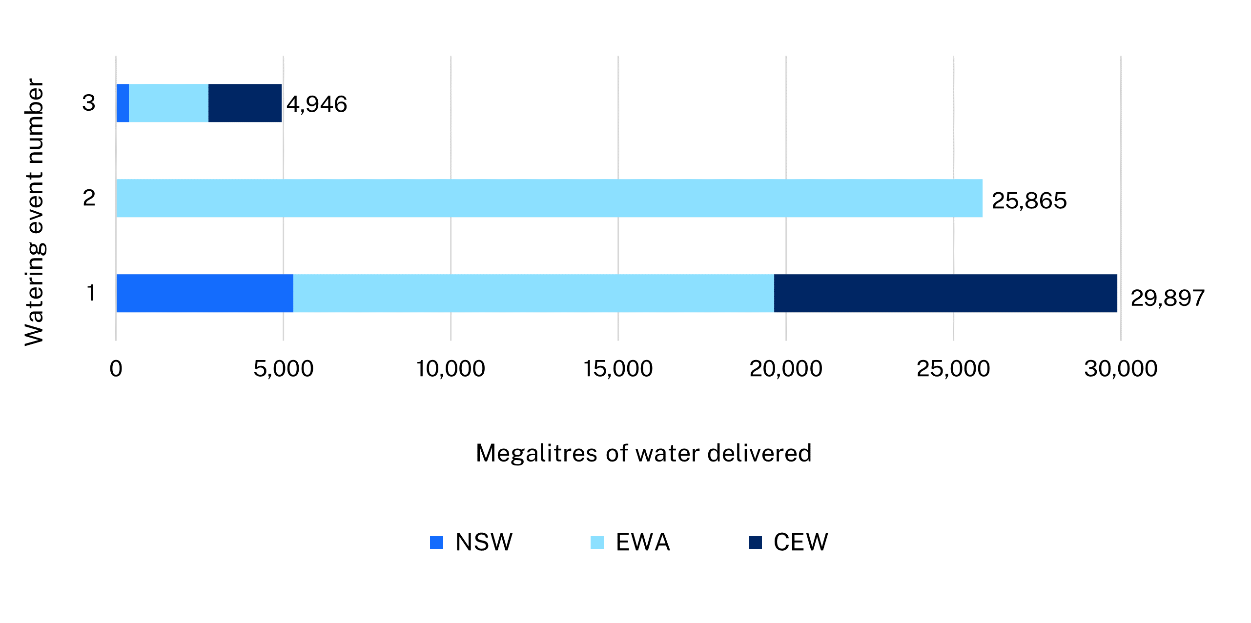
Under wet conditions, environmental water managers worked with partner agencies and stakeholders to coordinate the delivery of water for the environment in response to varying flows and dam spills. Actions aimed to:

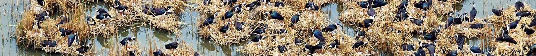
  • maintain water levels at key colonial waterbird colony sites in the Macquarie Marshes
  • allow the movement of native fish from the unregulated Lower Macquarie to the more secure conditions in the regulated mid-Macquarie River.

Map of sites in the Macquarie-Castlemaine catchment where environmental water was delivered in the 2022-23 water year, with corresponding volumes.

Catchment conditions

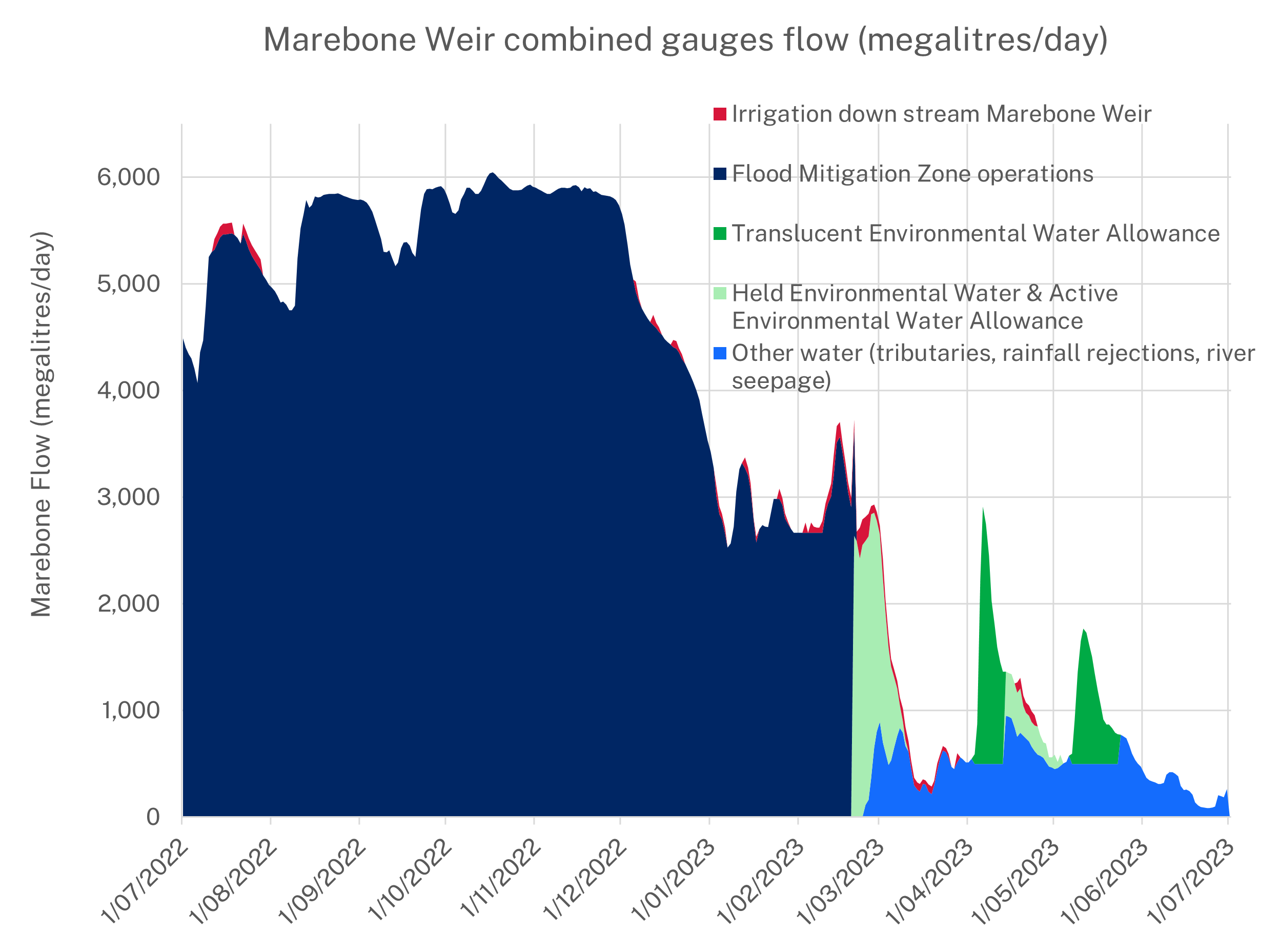
During late 2022 the weather in the Macquarie–Castlereagh catchment was influenced by a La Niña climate cycle, producing wet conditions and generally cool temperatures.

Burrendong Dam was still spilling from the start of the water year through to mid-February 2023. While dam operations aimed to minimise impacts to infrastructure, there were significant environmental benefits accrued. Windamere Dam also spilled in October 2022 – only the second time since commissioning in 1985.

The climatic influences of La Niña faded in early 2023, but autumn still brought some rainfall events to the catchment.

About the catchment

The Macquarie–Castlereagh catchment is in central west NSW and covers an area of 75,000 square kilometres. Major rivers are the Castlereagh, Macquarie and Bogan with major tributaries including the Cudgegong, Talbragar and Bell rivers. The catchment extends from the Blue Mountains to the Barwon River.

The Macquarie–Castlereagh catchment is home to the iconic Macquarie Marshes, one of the largest semi-permanent wetland systems and colonial waterbird breeding sites in inland Australia.

Water for Country

The Macquarie–Castlereagh is the Country of the Wiradjuri, Ngiyampaa, Wailwan and Kamilaroi Aboriginal peoples.

Water for Country is environmental water use planned by the Department of Planning and Environment and Aboriginal people to achieve shared benefits for the environment and cultural places, values and/or interests.

In the 2022–23 water year members were recruited to the Macquarie–Cudgegong Environmental Water Advisory Group, including a representative from the Wiradjuri nation. The department hopes to recruit further Aboriginal community representatives to this group.

Regional Water for Country staff and environmental water managers commenced an Aboriginal-led site-planning project with community members from Trangie that will continue into the next water year.

An Aboriginal waterways assessment was funded and undertaken on the Macquarie River by Wiradjuri Tubba-Gah people.

Environmental water managers prepared an annual watering plan in consultation with the Macquarie–Cudgegong Environmental Water Advisory Group. From this plan, the Annual environmental water priorities in the Macquarie-Castlereagh catchment 2022–23 was developed in response to a wet resource-availability scenario.

Aims for the use of water for the environment in the regulated Macquarie River were to:

  • support further wetland recovery and build resilience in key water-dependent vegetation communities in the Macquarie Marshes
  • improve ‘event-readiness’ of the Macquarie Marshes system for colonial bird breeding to maximise outcomes should breeding be initiated
  • support viable colonial waterbird breeding events, should they occur
  • support flow events that help recruitment of native fish into the local population – where possible, flows should target flow generalists and in-channel specialist species
  • provide volume to carryover for use in the next 1–2 years.

This table and chart provide a summary of 60,708 megalitres of water for the environment delivered in the Macquarie–Castlereagh catchment during the 2022–23 water year. This water complemented more than 1,174 gigalitres (GL) of tributary, flood mitigation and natural river flows as measured at Marebone Weir.

Figures were accurate at the date of publishing, but may be adjusted. Watering event numbers in the table and bar chart relate to location numbers marked on the map.

Bar chart showing water delivery to the Macquarie-Castlereagh catchment in the 2022-23 water year.

Notes: CEW = Commonwealth licensed environmental water; EWA = environmental water allowance accrued under the water sharing plan; NSW = NSW licensed environmental water.

Watering event number Location Outcomes Start
date
Finish
date
1 Macquarie summer colony support
Waterbird icon 20 Feb 2023 10 Mar 2023
2 Macquarie translucent environmental water allowance
Connectivity and water flow icon Flow-dependent native vegetation icon Native fish icon Waterbird icon 03 Apr 2023 23 May 2023
3 Macquarie autumn fish flow Connectivity and water flow icon Native fish icon 14 Apr 2023 03 May 2023

In 2022–23, NSW environmental water managers worked with the Macquarie–Cudgegong Environmental Water Advisory Group and Commonwealth Environmental Water Holder to adaptively manage water to achieve annual objectives.

Over summer 2022–23, the department worked with Water NSW on flood mitigation operations of Burrendong Dam. These high flows, and the significant tributary inflows, assisted colonial waterbird breeding in the Macquarie Marshes.

Following the dam spill, managed water for the environment was used in the regulated Macquarie to:

  • support colonial waterbird colonies in late February and early March 2023 (30 gigalitres (GL))
  • provide pulses in the mid-Macquarie River via triggering of the translucent environmental water allowance (25.8 GL)
  • assist young-of-year native fish to move as the catchment dried down in April 2023 by extending a translucent EWA flow event (4.9 GL).

This use of managed water is illustrated in this figure:

Chart showing how managed water for the environment was used in the regulated Macquarie. See text for details.

Remote sensing data indicated that over 230,000 hectares of the Macquarie Marshes was inundated in late October 2022. This represented a second very wet spring/summer in succession. When combined with the median-flow water year of 2020–21, this has been a highly beneficial time for the flow-dependent assets and values in the catchment.

As the weather warmed in spring 2022, the inundation and local rainfall drove large-scale colonial waterbird breeding in the Macquarie Marshes. Colonies formed over spring–summer 2022, with completion in late summer and early autumn 2023.

Over 197,000 colonial waterbird nests were recorded, including 4 large-scale ibis colonies, 9 large-scale night heron and egret colonies in river red gum areas, and at least 15 smaller colonies across the Marshes of various species. A range of other waterbird species also nested including ducks, herons, swamp hens and magpie geese.

Flows to the Barwon River occurred throughout the water year and were strong over summer.

A second summer of colonial waterbird breeding in the Macquarie Marshes

Ibis rookery in the Macquarie Marshes

Burrendong Dam near Wellington began spilling in spring 2021 following strong catchment rainfall. Burrendong Dam has space for flood mitigation, which is managed by WaterNSW to minimise flood impacts to infrastructure and where compatible, to fulfil environmental outcomes.

Flood mitigation efforts continued throughout 2022, wetting floodplains and connecting strongly through to the Barwon River. This inundation created ideal conditions for a second major colonial waterbird breeding event in 2 years in the Macquarie Marshes.

Large-scale waterbird colonies were recorded throughout the wetland, including 4 ibis colonies of 10,000 to 50,000 nests each, at least 9 large-scale night heron and egret colonies of over 5,000 nests each in river red gum forests, with many smaller colonies of ibis, egrets, spoonbills and herons also recorded.

Following completion of flood mitigation zone activity in February 2023, local staff from the NSW Department of Planning and Environment – Environment and Heritage, in partnership with the Commonwealth Environmental Water Holder (CEWH), managed water for the environment to maintain water levels in key parts of the Macquarie Marshes to see the last colonies fledge young.

The department and University of NSW undertook ground and aerial monitoring during the breeding events. This work indicated the colonies were successful. A number of birds were also caught and tagged for satellite tracking by the Commonwealth Scientific and Industrial Research Organisation (CSIRO).

We thank the land managers of the Macquarie Marshes and the CEWH for their support with monitoring resources as well as monitoring partners, the University of NSW, CSIRO and WaterNSW, for working with the department to support this spectacular breeding event that will improve the populations of waterbirds across the basin.

Contact us

Department of Planning and Environment