We report vegetation change in New South Wales (NSW) by:
- using the Statewide Landcover and Tree Study (SLATS) method, which reports on annualised rate (hectares/annum) of woody vegetation loss due to agriculture, forestry and infrastructure activities
- assessing landcover change on rural regulated land (under the Local Land Services Act 2013), which reports on woody and non woody vegetation loss.
Statewide woody vegetation change
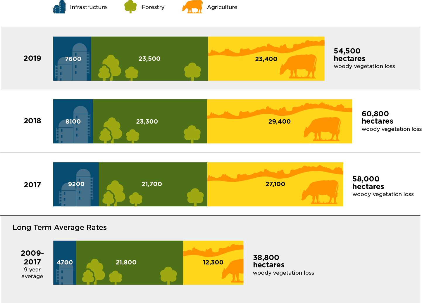
Results for the 2019 Statewide Landcover and Tree Study show that 54,500 hectares of woody vegetation was lost. Woody vegetation loss was slightly less than the previous year’s total of 60,800 hectares. This excludes fire-affected areas, which have the potential to regenerate.
The 2019 figure continues to exceed the 2009–2017 average at 38,800 hectares.
Woody vegetation loss attributed to agricultural activity remained higher in 2019 than the average observed under the previous legislative framework (2009–2017).
Loss due to forestry and infrastructure activities was relatively consistent with 2018 figures.
Read more about the Statewide Land and Tree Study program.
Summary report and data
Read the Woody vegetation change, Statewide Landcover and Tree Study: Summary report 2019.
Data for 2019 and previous years is available in Results woody vegetation change statewide landcover and tree study 2019 (XLS 200KB).
Rural regulated land
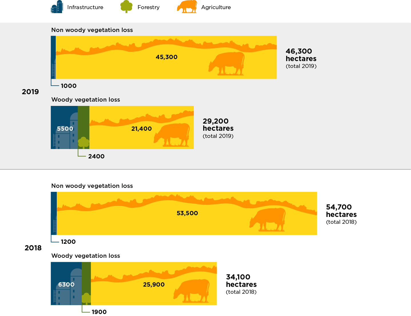
In 2019, about 46,300 hectares of non-woody vegetation, such as grasses, small shrubs and groundcover, and 29,300 hectares of woody vegetation was lost on rural regulated land. Regulated land represents the area of state subject to Part 5A of the Local Land Services Act 2013 (LLS Act), which came into effect in August 2017, as well as the provisions of the Land Management (Native Vegetation) Code 2018 (Land Management Code).
About 43 million hectares (54%) of land in New South Wales is categorised as rural regulated land.
The LLS Act provides transitional arrangements for determining land categorisation. Until an area has been designated on the Native Vegetation Regulatory Map, landholders can self-assess groundcover such as grasses, forbs and herbs to determine the regulatory status of an area (Category 1 – exempt land, or Category 2 – regulated land). Landholder self-assessment of groundcover within the transitional mapping period contributes to reported changes in non woody vegetation cover.
Figures for the 2018 non-woody vegetation loss have been updated to reflect increased clearing identified since release of the 2018 report. This is due to higher resolution or later imagery that verifies previously detected change as a conversion from native vegetation to cropping.
Authorised clearing
Under the Local Land Services Act 2013, the Land Management Code:
- authorises clearing of native vegetation on Category 2 – regulated land
- provides for establishment and management of set aside areas
- authorises recategorisation of land.
There was a decline in total reported clearing across New South Wales in 2019. This is reflected in a reduction in clearing of native groundcover and woody vegetation subject to the LLS Act.
In 2019, the area of total clearing authorised under the LLS Act was 11% (an increase on 2018). The area of total clearing under the previous legislative framework, the Native Vegetation Act 2003 (NV Act), was 14% (a decrease on 2018).
There remains a high percentage of unexplained clearing in 2019 at 74%, a 2% variance on last year’s figure of 76%. When divided into landcover types, 90% of non-woody vegetation loss and 47% of woody vegetation loss remain unexplained.
Unexplained clearing refers to areas in which the department does not know the specific details of the clearing. This could be attributed to clearing undertaken as part of:
- allowable activities
- land management activities under the Land Management Code that do not require approval
- landholder self-assessment of level of disturbance of grasslands or groundcover.

Summary report and data
Read the Woody and non-woody landcover change on rural regulated land: Summary report 2019.
Data for 2019 and previous years is available in Results for landcover change on rural regulated land 2019 (XLSX 300KB).
Fire and vegetation loss
Vegetation loss due to fire was reported as part of our Statewide Landcover and Tree Study reporting, but in 2021 we started publishing annual reports on fire extent and severity across the landscape using fire extent and severity mapping (FESM).
Our first FESM annual report covers the 2019–20, 2018–19 and 2017–18 fire seasons.
Each FESM annual report will summarise the fire season for that year and be accompanied by a spreadsheet with data analyses for the reported fire season, as well as comparisons with previous fire seasons.
Data is also publicly available through the Sharing and Enabling Environment Data portal.