We report vegetation change in New South Wales (NSW) by:
- using the Statewide Landcover and Tree Study (SLATS) method, which reports on annualised rate (hectares/annum) of woody vegetation loss due to agriculture, forestry and infrastructure activities
- assessing landcover change on rural regulated land (under the Local Land Services Act 2013), which reports on woody and non woody vegetation loss.
Statewide woody vegetation change
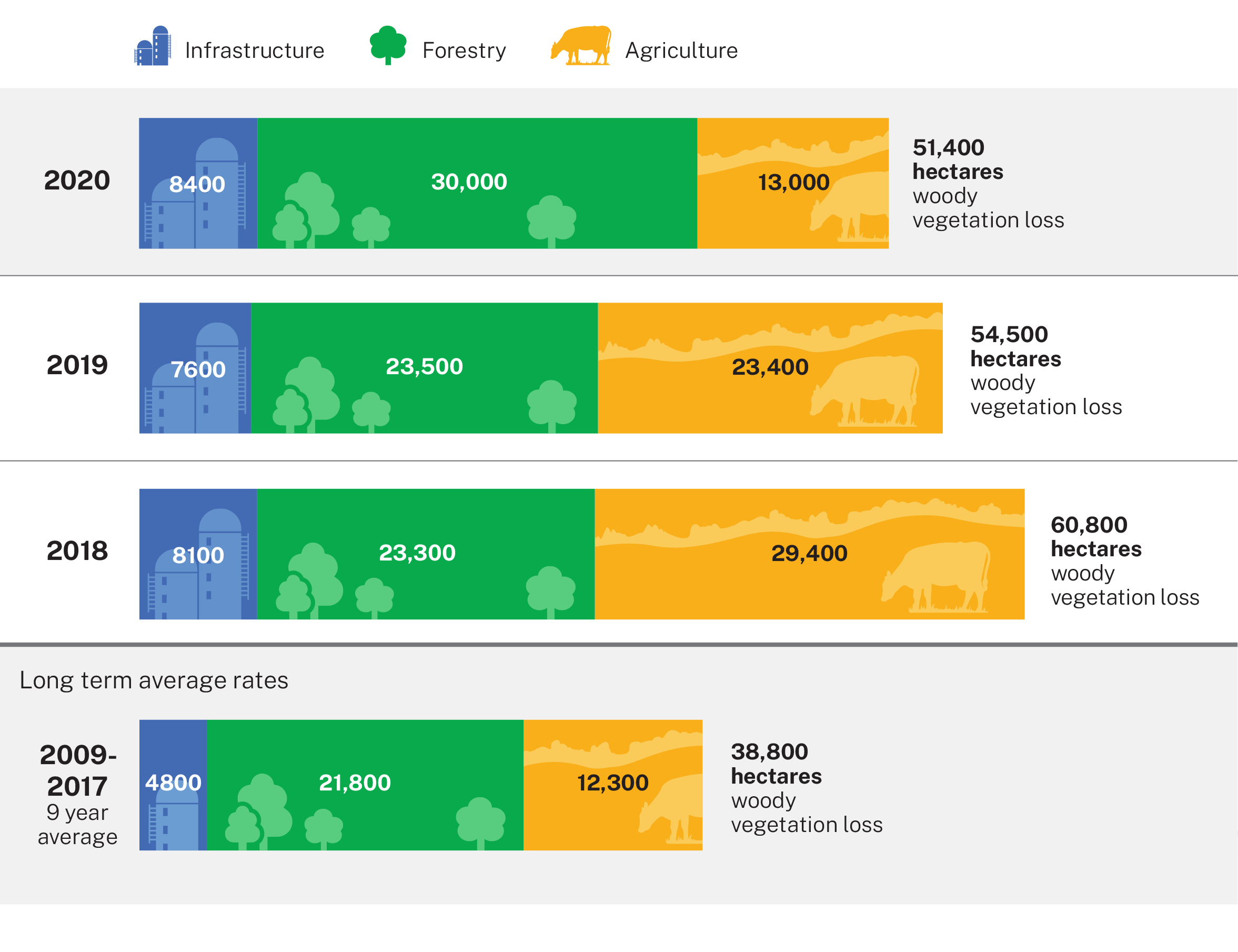
Results for the 2020 Statewide Landcover and Tree Study show that 51,400 hectares of woody vegetation was lost. Woody vegetation loss was slightly less than the previous year’s total of 54,500 hectares. This excludes fire-affected areas, which have the potential to regenerate.
The 2020 figure continues to exceed the 2009–2017 average of 38,800 hectares.
The rate of woody vegetation loss attributed to agriculture decreased by 44% from 2019. The rate of woody vegetation loss due to forestry harvesting increased by 28%, while the rate of infrastructure clearing remained stable.
Read more about the Statewide Land and Tree Study Program.
Summary report and data
Read the Woody vegetation change Statewide Landcover and Tree Study: Summary report 2020.
Data for 2020 and previous years is available in Results woody vegetation change statewide landcover and tree study 2020 (XLS 594KB).
Rural regulated land
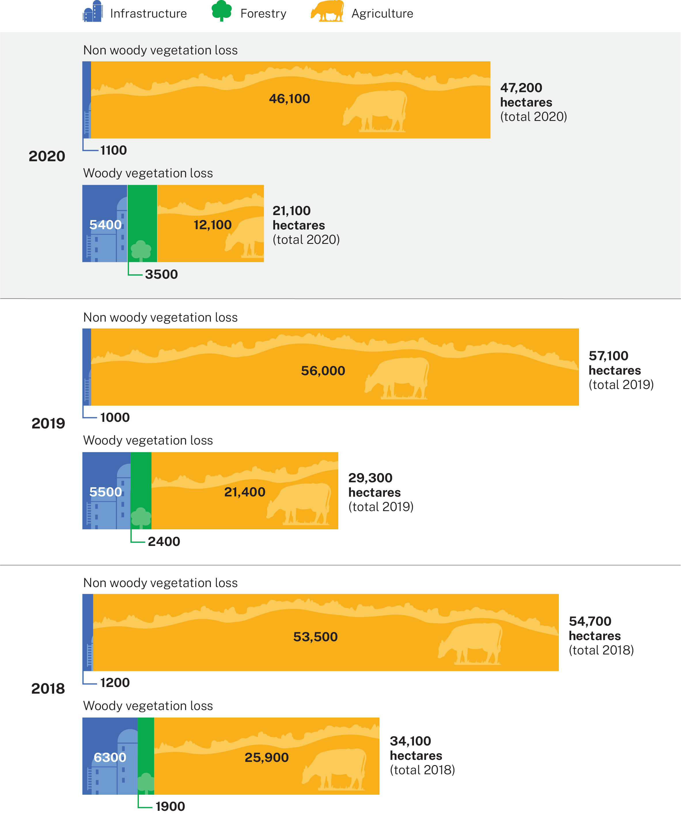
In 2020, about 47,200 hectares of non woody vegetation, such as grasses, small shrubs and groundcover, and 21,100 hectares of woody vegetation were lost on rural regulated land. Rural regulated land represents the area of the state subject to Part 5A of the Local Land Services Act 2013 (LLS Act), which came into effect in August 2017, as well as the provisions of the Land Management (Native Vegetation) Code 2018 (Land Management Code).
About 43 million hectares (54%) of land in New South Wales is categorised as rural regulated land.
The LLS Act provides transitional arrangements for determining land categorisation. Until an area has been designated on the Native Vegetation Regulatory Map, landholders can self-assess groundcover such as grasses, forbs and herbs to determine the regulatory status of an area (Category 1 – exempt land, or Category 2 – regulated land). Landholder self-assessment of groundcover within the transitional mapping period contributes to reported changes in non woody vegetation cover.
Figures for the 2019 non woody vegetation loss have been updated to include areas noted as possible clearing in 2019 that were confirmed using the 2020 analysis. This is due to higher resolution or later imagery that verifies previously detected change as a conversion from native vegetation to cropping. Further information is available in the summary report.
Authorised clearing
Under the LLS Act 2013, the Land Management Code:
- authorises clearing of native vegetation on Category 2 – regulated land
- provides for establishment and management of set aside areas
- authorises recategorisation of land.
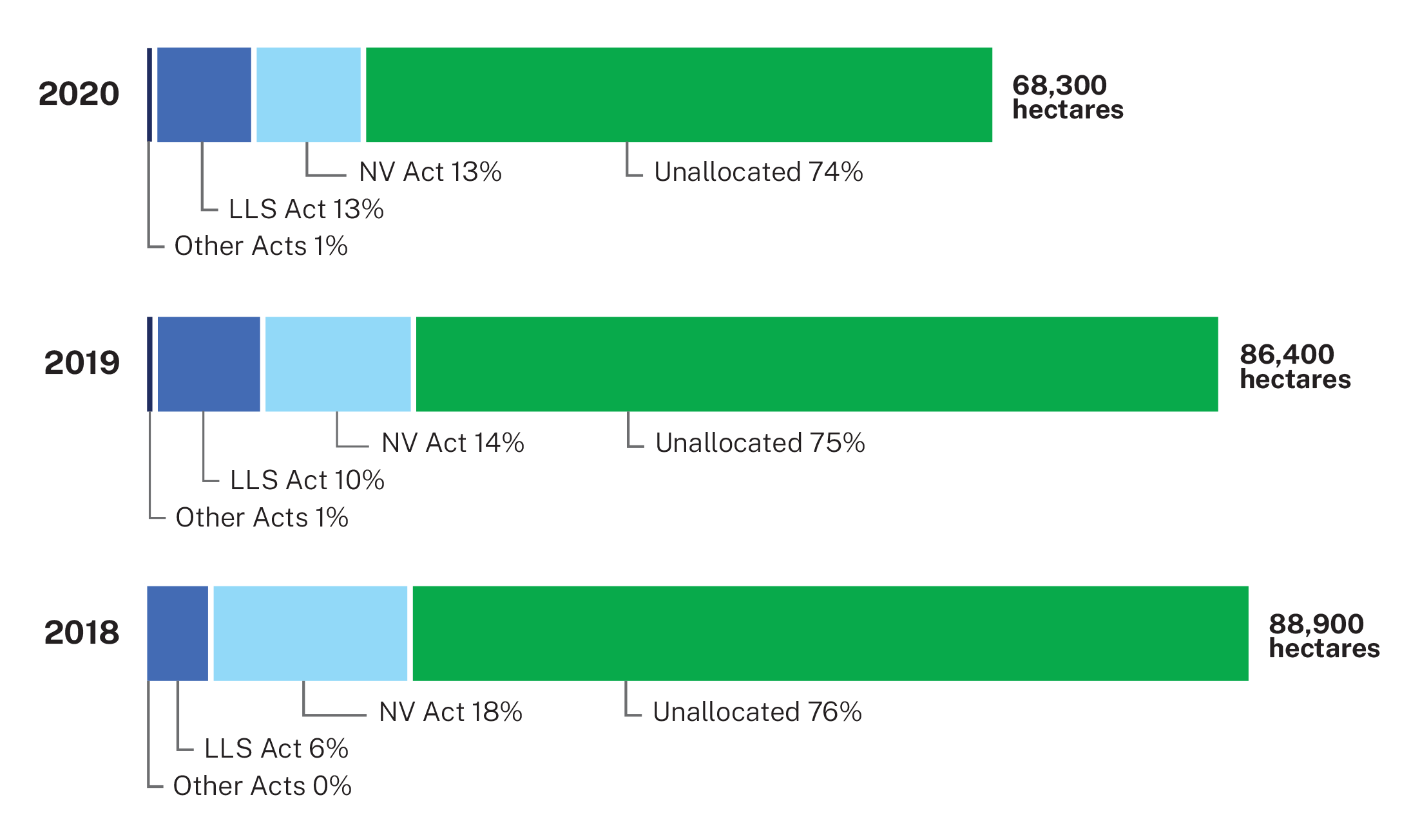
There was a decline in total reported clearing across rural regulated land in New South Wales in 2020. Twenty-five per cent of clearing detected on rural regulated land was recorded as authorised. Of this, 12% was authorised under the LLS Act and 13% under the Native Vegetation Act 2003 (NV Act). Less than 1% of clearing was authorised under other legislation. These proportions represent a gradual move in authorised clearing area away from NV Act approvals towards LLS Act approvals.
Unallocated (previously ‘unexplained’) clearing in 2020 remains high at 75% of total clearing. When divided into landcover types, 83% of non woody vegetation loss and 52% of woody vegetation loss remain unallocated.
Unallocated clearing refers to clearing for which the Department of Climate Change, Energy, the Environment and Water (the department) does not have a record of authorisation.
Unallocated clearing may include lawful clearing of landcover on rural regulated land that does not require an approval, notification and/or keeping of records; vegetation loss which the department does not have access to information or records that authorise or explain the clearing; as well as areas that have been cleared unlawfully or are not fully compliant with approvals.
The department and Local Land Services are working together to consider how some unallocated clearing can be identified and explained. This includes gathering available evidence and data to allocate clearing events, where possible, as either:
- clearing under transitional arrangements
- allowable activities
- clearing under the Land Management Code
- illegal clearing.
Summary report and data
Read the Woody and non woody landcover change on rural regulated land: Summary report 2020.
Data for 2020 and previous years is available in Results for landcover change on rural regulated land 2020 (XLSX 972KB).
Read more about unallocated clearing.
Fire and vegetation loss
Detected losses in woody vegetation resulting from fire were included in the SLATS report until 2018.
We now report on fire extent and severity mapping (FESM) each year.