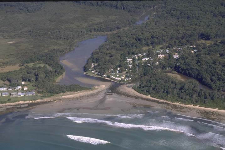
Arrawarra Creek estuary is an intermittently closed/open lagoon, which meets the sea at the township of Arrawarra on the north coast of New South Wales. Arrawarra Gully meets the creek close to the estuary entrance to form the lagoon.
Water quality report card
As part of our water quality monitoring program we assess the water quality and ecosystem health of an estuary using a range of relevant indicators. We sample a subset of the estuaries located between the Queensland border and Taree every 3 years. The most recent sampling in Arrawarra Creek was completed over the 2018–19 summer, when 2 sites were sampled on a monthly basis.
This report card represents 2 water quality indicators that we routinely measure: the amount of algae present and water clarity. Low levels of these 2 indicators equate with good water quality.
The report card shows the condition of the estuary was good with:
- algae abundance graded good (B)
- water clarity graded good (B)
- overall estuary health graded good (B).
Grades for algae, water clarity and overall are represented as:
- A – excellent
- B – good
- C – fair
- D – poor
- E – very poor.
Coffs Harbour City Council, in collaboration with the University of New England’s EcoHealth Program, have carried out detailed ecosystem health monitoring in Arrawarra Creek. The results of the monitoring program, including a detailed water quality report card, are available on the Coffs Harbour City Council website.
Go to estuary report cards to find out what each grade means, read our sampling, data analysis and reporting protocols, and find out how we calculate these grades.
We have monitored water quality in Arrawarra Creek estuary since 2009. This table shows the water quality grades for this estuary over that time.
| Year | Algae | Water clarity | Overall grade |
|---|---|---|---|
| 2009–10 | C | E | D |
| 2012–13 | A | C | B |
| 2015–16 | B | D | B |
Physical characteristics
| Estuary type | Lagoon |
|---|---|
| Latitude | –30.06 (ºS) |
| Longitude | 153.2 (ºE) |
| Catchment area | 17.8 km2 |
| Estuary area | 0.1 km2 |
| Estuary volume | 43.9 ML |
| Average depth | 0.4 m |
Notes: km2 = square kilometres; m = metres; ML = megalitres.
Water depth and survey data
Bathymetric and coastal topography data for this estuary are available in our data portal.
Land use
The catchment of Arrawarra Creek is predominantly forested with most of the upper catchment managed by the Forestry Corporation. The lower catchment is a mix of forested and developed land. Only 15% of the catchment is disturbed, most of which is for urban land use associated with the township of Arrawarra. The Pacific Highway cuts through the middle of the catchment.
National and marine parks
- Garby Nature Reserve, covering 117 hectares, is adjacent to Arrawarra Creek, and forms a large part of the estuary’s catchment.
- Arrawarra Creek is part of the Solitary Islands Marine Park.
Community involvement
- Coffs Harbour Regional Landcare is an umbrella group for volunteers within the local government area, which includes Arrawarra Creek.
Local government management
Local councils manage estuaries within their area unless the estuary is attached to a marine park.
Arrawarra Creek is managed by the Coffs Harbour City Council. The estuary is also managed as part of the Solitary Islands Marine Park.
Threatened species
Garby Nature Reserve, situated beside Arrawarra Creek, provides important habitat for the vulnerable squirrel glider (Petaurus norfolcensis).
Find out more about the biodiversity in our estuaries.