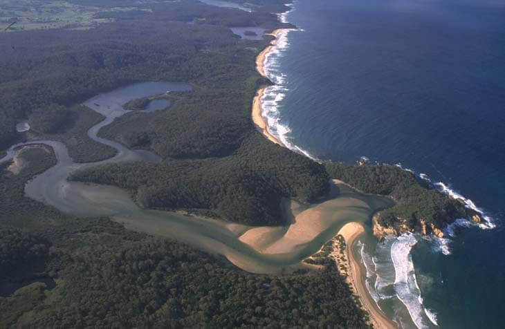
Nelson Lagoon is located on the far south coast of New South Wales. It is classed as a barrier river estuary and its entrance remains open to the ocean.
The estuary contains wetlands that are listed in the Directory of Important Wetlands in Australia for providing significant saltmarsh habitat.
The estuary has several small waterways, such as Duckhole Bay and Sandfly Bay. The main tributary to the lagoon is Nelson Creek.
The lagoon is located within Mimosa Rocks National Park and is a popular for swimming, fishing and birdwatching.
Water quality report card
As part of our water quality monitoring program we assess the water quality and ecosystem health of an estuary using a range of relevant indicators. We sample a subset of the estuaries between Wollongong and the Victorian border every 3 years. The most recent sampling in Nelson Lagoon was completed over the 2020–21 summer, when 2 sites were sampled on a monthly basis.
This report card represents 2 water quality indicators that we routinely measure: the amount of algae present and water clarity. Low levels of these 2 indicators equate with good water quality.
The report card shows the condition of the estuary was excellent with:
- algae abundance graded good (B)
- water clarity graded excellent (A)
- overall estuary health graded excellent (A).
Grades for algae, water clarity and overall are represented as:
- A – excellent
- B – good
- C – fair
- D – poor
- E – very poor.
Go to estuary report cards to find out what each grade means, read our sampling, data analysis and reporting protocols, and find out how we calculate these grades.
We have monitored water quality in Nelson Lagoon since 2011. This table shows the water quality grades for this estuary over that time.
| Year | Algae | Water clarity | Overall grade |
|---|---|---|---|
| 2011–12 | A | A | A |
Physical characteristics
| Estuary type | Barrier river |
|---|---|
| Latitude (ºS) | –36.69 |
| Longitude (ºE) | 149.99 |
| Catchment area (km2) | 27 |
| Estuary area (km2) | 1.3 |
| Estuary volume (ML) | 1077.8 |
| Average depth (m) | 0.9 |
Notes: km2 = square kilometres; m = metres; ML = megalitres.
Water depth and survey data
Bathymetric and coastal topography data for this estuary are available in our data portal.
Land use
The catchment of Nelson Lagoon falls almost entirely within Mimosa Rocks National Park. Urban and grazing areas account for 2% of land use.
National and marine parks
- Mimosa Rocks National Park surrounds Nelson Lagoon.
- This estuary does not flow into a marine park.
Citizen science projects
- The Far South Coast Conservation Management Network supports the local community to better manage native biodiversity. The network organises citizen science projects, provides information for private landowners, manages a local plant database, and coordinates events.
Community involvement
- Bermagui Dune Care Group is a small group working to revegetate the coastal area near Bermagui.
- The Bega River and Wetlands Landcare Group is a volunteer group dedicated to improving the health of the Bega River, wetlands and floodplains.
- The Far South Coast Landcare Association is a volunteer environmental and conservation organisation that works to improve management of local land and water.
Seafood harvest area status
The NSW Food Authority website lists the current status of oyster/shellfish harvest areas.
Local government management
Local councils manage estuaries within their area unless the estuary is attached to a marine park.
Bega Valley Shire Council manages this estuary.
Threatened species
Nelson Lagoon provides important habitat for waterbirds and shorebirds, including hooded plovers and pied oyster catchers.
Read more about the biodiversity in our estuaries.