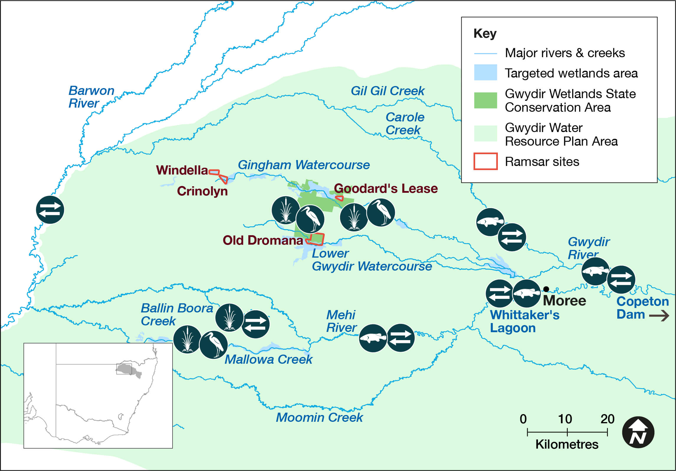
The Gwydir catchment covers 25,596 square kilometres. The eastern upland creeks mainly flow into the Gwydir River upstream of Copeton Dam. Downstream, on the western floodplain, the main Gwydir River splits into its main distributaries – the Mehi River (south), Carole Creek (north), Lower Gwydir and Gingham Channels (west/central).The Big Leather (Lower Gwydir) watercourse supports the State’s largest stand of marsh club rush. The Gingham Watercourse contains important colonial waterbird breeding habitats. The Gwydir wetlands are home to four wetland parcels listed under the Gwydir Ramsar landholder agreement. The Gwydir catchment supports important Aboriginal cultural values for the Kamilaroi/ Gomeroi people.
Water for rivers and wetlands
In 2022–23 water managers will use an adaptive approach to support fish and colonial waterbird populations and downstream connectivity by using water for the environment to maintain a natural flow regime. Contingencies are also in place to provide environmental flows to water-dependent assets when required.
The Gwydir catchment experienced improved water availability in the later part of 2020, with wet conditions continuing through 2021 and 2022. Major flooding occurred across the Gwydir River floodplain during March and April 2022.
During the 2021–22 water year, water managers used water for the environment to return flows into the downstream Barwon River via the Mehi River. Whittaker’s Lagoon was refilled. They also used water for the environment to support a significant colonial waterbird breeding event that occurred in the Gwydir Wetlands after natural flooding.
Weather and water forecast
The El Niño–Southern Oscillation (ENSO1) outlook remains at La Nina, with a return to neutral ENSO during winter, meaning average or wetter conditions are likely. Further, the Bureau of Meteorology has forecast average temperatures in Central NSW.
Water managers have prepared watering plans that consider a range of weather and water availability scenarios. This is known as resource availability scenario planning. Moderate to wet conditions are forecast for the Gwydir catchment in 2022–23.
1. ENSO: The interaction between the sea surface and atmosphere over the Pacific Ocean which results in dryer or wetter conditions (El Nino or La Nina).
Resource availability scenario
Current forecast: Moderate to wet
| Conditions | Main aim | Other aims |
|---|---|---|
| Very dry | Protect | Avoid critical loss Maintain key refuges Avoid catastrophic events |
| Dry | Maintain | Maintain river functioning Maintain key functions of high priority wetlands |
| Moderate | Recover | Improve ecological health and resilience Improve opportunities for plants and animals to breed, move and thrive |
| Wet to very wet | Enhance | Restore key floodplain and wetland linkages Enhance opportunities for plants and animals to breed, move and thrive |
Key planned actions for 2022–23
Waterbirds
Heavy catchment rainfall, resulting in large river flows and floodplain flooding, may trigger colonial waterbird breeding events in the wetland systems. In response, water managers may provide 15–25 gigalitres (GL) of held water for the environment to support these events.
Native fish
Water managers may use up to 25 GL to support native fish communities. Early season environmental flows may be triggered by inflows at Copeton Dam with a view to deliver supporting environmental flows later in the season.
Vegetation
Water managers may use up to 40 GL across the catchment. Rainfall may trigger delivery of held environmental water into the Mehi River, Carole Creek and/or the Gwydir wetlands system. Water managers are likely to release further environmental flows into the Mallowa Watercourse this season to continue vegetation improvements.
Connectivity
Water managers may provide up to 14 GL of water for the environment in the Carole Creek, Mehi and Gwydir rivers this season to provide connectivity support to native fish communities during extended dry periods. In addition to in-valley connectivity, water managers may consider addressing connection to the Barwon River if warranted during the year.
The Department of Climate Change, Energy, the Environment and Water (the department) is supporting the health and resilience of rivers and wetlands by delivering water for the environment where and when it is needed. We use the best available science, management expertise and experience to manage water across the landscape. This statement of annual priorities identifies the waterways and wetlands that are likely to receive water.
Our decision-making process considers:
- expected availability of water in the coming year
- conditions of the previous year
- current health of the plants and animals in these ecosystems.
Community-based Environmental Water Advisory Groups (EWAGs) provide feedback and advice to the department on the management of water for the environment.
The NSW Government works with the Commonwealth Environmental Water Holder to manage water in the catchment.
Water for the environment is a share of the water in dams and rivers that is set aside to support the long-term health of local rivers, creeks and wetlands. Healthy rivers carry water to homes, farms, schools and businesses. Rivers and wetlands are important cultural and spiritual sites for Aboriginal people, as well as the broader community.
Planned environmental water
| Source | Maximum volume available (gigalitres) | Volume expected 1 July under current conditions (gigalitres) |
|---|---|---|
| Environmental water allowance | 90 GL | 90 GL |
Water licenced to New South Wales
| Source | Maximum volume available (gigalitres) | Volume expected 1 July under current conditions (gigalitres) |
|---|---|---|
| General security | 25.5 GL | 25.5 GL |
| Supplementary | 3 GL | Event-dependent |
| High security | 1.2 GL | 1.2 GL |
Water licenced to the Commonwealth
| Source | Maximum volume available (gigalitres) | Volume expected 1 July under current conditions (gigalitres) |
|---|---|---|
| General security | 134.2 GL | 134.2 GL |
| High security | 4.5 GL | 4.5 GL |
| Supplementary | 20.4 GL | Event-dependent |
Notes: This is an indicative summary of expected volumes to be available. For further detail and information on available volumes you can contact the region via the Department of Climate Change, Energy, the Environment and Water on 1300 361 967.
1 gigalitre = 1000 megalitres; 2.5 megalitre = 1 Olympic swimming pool.
Planned and past watering events
- Gwydir Catchment – Water for the environment: Annual priorities 2021–22
- Gwydir catchment: Annual environmental watering priorities 2020–21
- Gwydir: Annual environmental watering priorities 2019–20
- Gwydir catchment: Annual Environmental Watering Priorities 2018–19
- Gwydir catchment: Annual environmental watering priorities 2017–18
- Gwydir Water Resource Plan Area: Statement of annual environmental watering priorities 2016–17
- Gwydir Water Resource Plan Area: Statement of annual environmental watering priorities 2015–16
- Water for environment outcomes 2021–22