- A Transitional Native Vegetation Regulatory map covering New South Wales was published online in 2017 to protect areas with the greatest environmental value.
- The transitional map displays category 2 (vulnerable) land and category 2 (sensitive) land described in the Local Land Services Act 2013. It can be used to check for sensitive or vulnerable land mapping on your property. Restrictions apply to clearing of vegetation in these areas.
- Landholders can seek a free review of the transitional map as it relates to their land. The review will normally be completed in 40 days.
- A draft Native Vegetation Regulatory map is also available to landholders across New South Wales. Read more about the draft Native Vegetation Regulatory map.
Areas where the transitional map applies
The Transitional Native Vegetation Regulatory map is available to all landholders across New South Wales.
The transitional map, published in 2017, displays vulnerable and sensitive regulated land and legally restricts land clearing in those areas. A limited range of allowable activities are permitted in these mapped areas.
The transitional map remains in place statewide. You can request a free review of the Transitional Native Vegetation Regulatory map anytime.
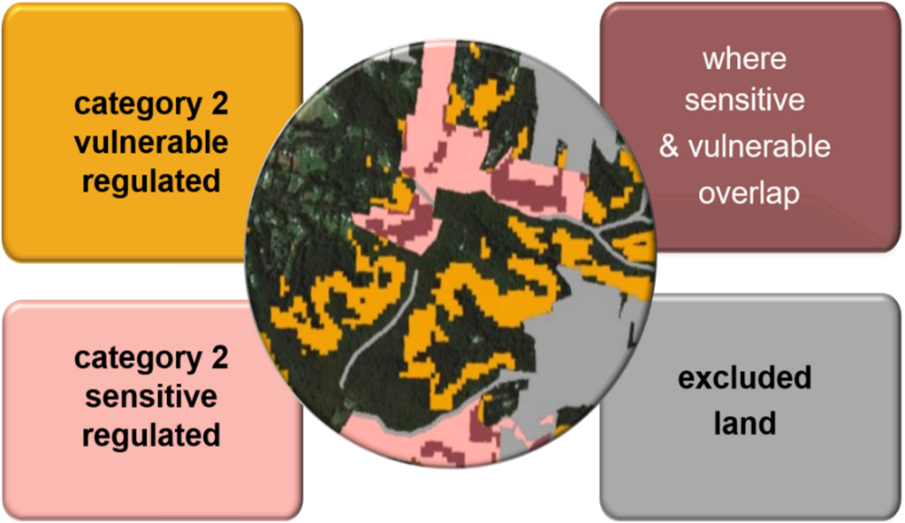
There are 4 different colours you might see on your map:
- category 2-vulnerable regulated land (orange) is land where clearing of native vegetation may be limited under the Land Management (Native Vegetation) Code 2018, and a limited range of allowable activities are permitted
- category 2-sensitive regulated land (pink) is land where clearing is not permitted under the Land Management Code (Native Vegetation) Code 2018, and a limited range of allowable activities is permitted
- excluded land (grey) is land where the Land Management (Native Vegetation) Code 2018 and allowable activities do not apply
- land where vulnerable and sensitive regulated mapping overlaps is displayed as brown.
Go to the Transitional Native Vegetation Regulatory map viewer.
What do the categories mean?
Criteria that apply to each land category
Each land category is determined by various criteria as outlined in the Local Land Services Act and Regulation.
| Land categories | Criteria |
|---|---|
| Vulnerable regulated land (subcategory of Category 2) |
|
| Sensitive regulated land (subcategory of Category 2) | Where the Environment Agency Head reasonably believes it to contain:
Land contained in the following types of agreements:
Land required to be set aside, offset or retained as a condition of development consent or subject to a remedial direction, including:
|
Benefits of the transitional map for a landholder
Simplifying self-assessment
The Transitional Native Vegetation Regulatory map identifies areas of land containing category 2-sensitive and vulnerable regulated land to which restrictions for clearing native vegetation apply.
Discover economic opportunities
You may own areas mapped as sensitive, vulnerable or category 2 (regulated) land, which are natural capital assets that could generate economic benefits.
These areas can potentially provide economic opportunities, including:
- biodiversity credits: generating biodiversity credits for sale through the Biodiversity Credits Supply Fund and Taskforce
- carbon credits: receiving incentives and private equity through carbon trading schemes.
Go to the Biodiversity Credits Supply Fund.
Contact Local Land Services for further advice or approvals
If you have viewed your map and require more information about allowable activities that might be available to you or for approval to clear native vegetation on regulated land, please visit Local Land Services regions or call 1300 795 299.
Request a free category explanation report or map review
If you would like a category explanation report or a map review, or you need any other information, please complete and submit this enquiry form.