Habitat health, waterbird breeding and connectivity were the focus of environmental flows in 2022–23.
Key outcomes
In 2022–23, we saw a return to moderate and wet to very wet conditions across the catchment. These conditions provided a second consecutive season for colonial waterbirds to breed and prosper in the Gwydir Wetlands. Environmental water managers worked with partner agencies and stakeholders to coordinate the delivery of water for the environment, which:
- supported an estimated 60,000 pairs of colonially nesting waterbirds (16 species) to reproduce, including the largest nesting colony of around 15,000 nests
- promoted health and resilience, and fostered reproduction of wetland and floodplain vegetation communities supporting the upstream river environment
- increased connectivity between and within catchment river systems, allowing native fish communities to move freely to find suitable foraging and breeding opportunities.
Catchment conditions
During the 2022–23 year, the Gwydir catchment experienced weather conditions that again provided positive water availability.
The high availability of water enabled the planned environmental water account to reach 200%, general security entitlements reaching 150% and 100% of high-security entitlement allocations. Significant releases were also made from Copeton Dam, which reached 100% capacity, and several supplementary announcements were made.
The resulting wet conditions were ideal for colonial waterbird breeding for a second year in succession. These circumstances have not occurred in the Gwydir since the late 1990s.
About the catchment
The Gwydir catchment is in northern New South Wales and covers an area of 25,596 square kilometres. Located in temperate and subtropical climate zones, rainfall is variable across the catchment with an annual average of 585 millimetres at Moree.
The major tributaries are Copes, Moredun, Georges, Laura, Myall, Halls and Tycannah creeks and Horton River, where the eastern upland creeks (Copes, Moredun, Georges and Laura) mainly flow into the Gwydir River upstream of Copeton Dam. Downstream, on the western floodplain, the main Gwydir River splits into its main distributaries – the Mehi River (south), Carole Creek (north), Lower Gwydir and Gingham Channels (west/central). Breaking off the Mehi River on its southern side are Moomin, Mallowa and Ballin Boora creeks.
The nationally and internationally significant Gwydir Wetlands are a near-terminal wetland delta dominated by semi-permanent wetland vegetation in a semi-arid floodplain. The Big Leather (Lower Gwydir) watercourse supports the state’s largest stand of marsh club rush, and both the Lower Gwydir and Gingham watercourses contain important colonial waterbird breeding habitats.
Water for Country
The Gwydir catchment is Country to the Kamilaroi/Gomeroi Aboriginal peoples.
Water for Country is environmental water use planned by the Department of Planning and Environment and Aboriginal people to achieve shared benefits for the environment and cultural places, values and/or interests. In the 2022–23 water year in the Gwydir, environmental water managers further developed and established relationships with Aboriginal groups and people by:
- supporting 2 new Aboriginal members on the Gwydir Environmental Water Advisory Group (EWAG) to engage with the EWAG process
- assisting with funding for the Ozfish Moree Chapter to connect with the local Aboriginal community and achieve outcomes at Whittaker’s Lagoon – the project seeks to use the lagoon area as an outdoor classroom for Aboriginal youth to connect with Country and learn cultural and river restoration knowledge
- including ‘Support for the Ozfish project at Whittaker’s Lagoon’ as a watering principle within the annual water planning of the Gwydir EWAG from the 2022–23 water year onwards.
The Gwydir Reconnecting Watercourse Country program is leading the establishment of an Aboriginal environmental water group in the Gwydir. This pilot has been supported by various government agencies at the federal and state level.
Meetings have been held with various groups and individuals including Moree, Collarenebri and Mungindi Local Aboriginal Land Council, native title applicant group, Elder’s group, youth and health service providers. The group will work, and provide advice, on issues connected to environmental water. Work areas will include flow deliveries, culture, knowledge and environmental outcomes.
Watering aims
Under an expected moderate and wet to very wet resource availability scenario, the Gwydir Environmental Water Advisory Group developed its Annual environmental water priorities in the Gwydir catchment 2022–23.
Objectives for the use of water for the environment were to:
- support colonial waterbird breeding events triggered by natural floodplain flooding
- support and build further wetland resilience in key water-dependent vegetation communities, in particular the Mallowa Wetlands
- create and support flow events to assist the recruitment of native fish into the local population
- support environmental, cultural, and social aspects of Whittaker’s Lagoon.
Should the need arise and when required other objectives are to:
- support Barwon River connection flows via Mehi River and/or Carole Creek
- protect refuge pools in dry conditions/low flows
- facilitate unplanned contingency requiring water for the environment, for example, promote wetland recovery following fires
- maximise carryover for use in future dry times.
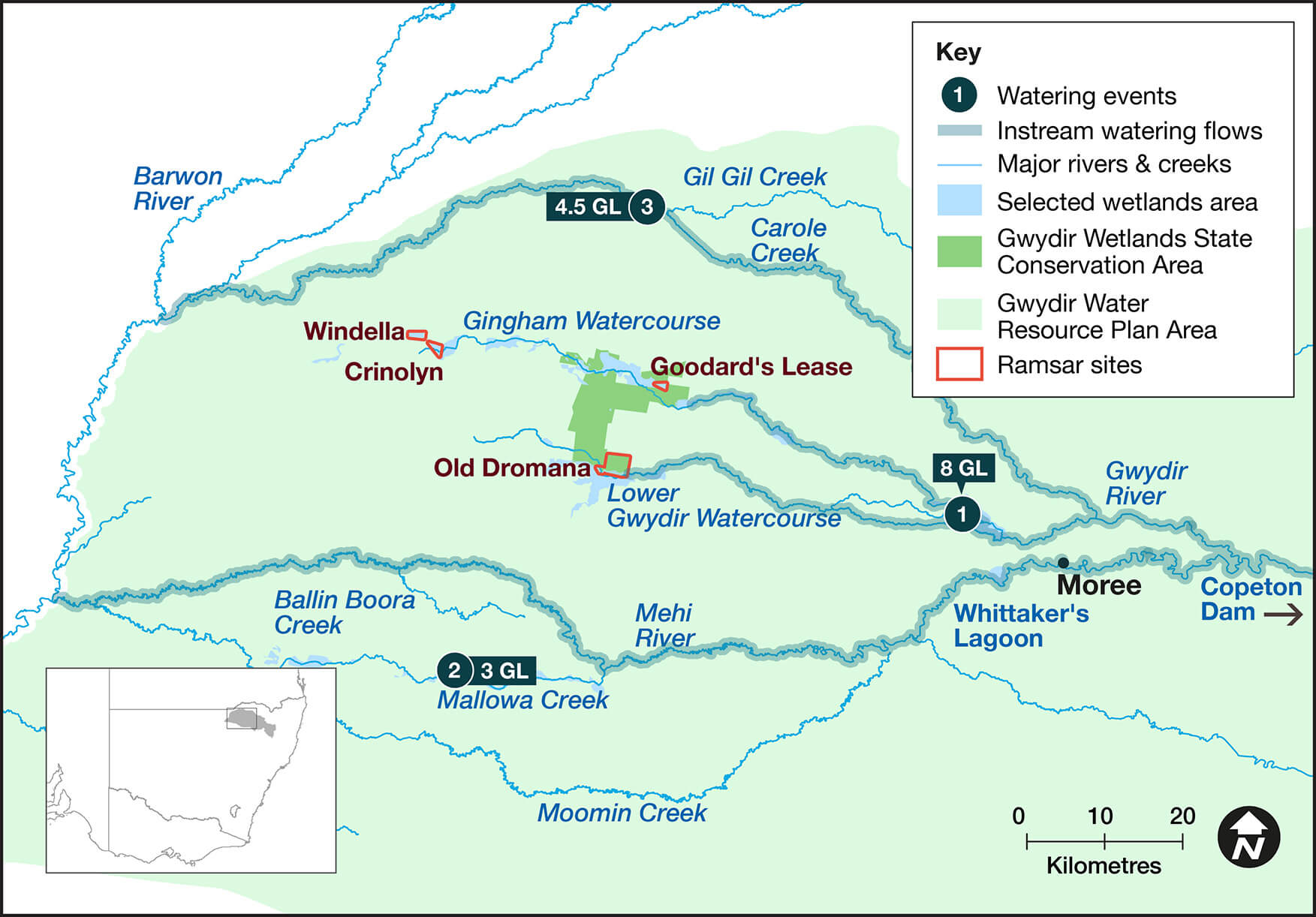
Water delivery
This table and chart provide a summary of 15,511 megalitres (ML) of water for the environment delivered in the Gwydir catchment during the 2022–23 watering year.
In addition to delivered water, 33,209 ML was provided from upstream tributary inflows to the Gwydir Wetlands by the sharing rules contained in the Gwydir Regulated River Water Sharing Plan.
During the Northern Refresh Flow (event 3), the Commonwealth Environmental Water Holder delivered 4,508 ML of held environmental water via Carole and Gil Gil creeks into the Barwon River. DPE – EHG managed a total of 8,629 ML into Gil Gil Creek as a planned water diversion under the Gwydir Regulated River Water Sharing Plan rules. Further flows were also made, via the Mehi River into the Barwon River. A total of 10,000 ML of planned water was diverted into the Barwon River by DPE – EHG for the Northern Refresh Flow event.
Figures were accurate at the date of publishing but may be adjusted. Watering event numbers in the table and bar chart relate to location numbers marked on the map.
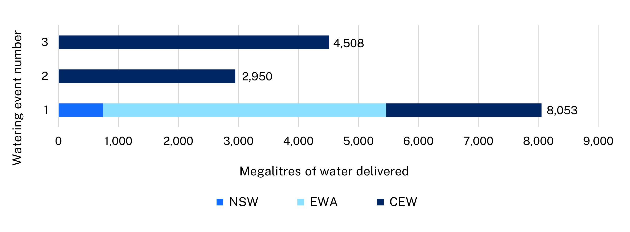
Notes: CEW = Commonwealth licensed environmental water; EWA = environmental water allowance accrued under the Water Sharing Plan; NSW = NSW licensed environmental water; TLM = The Living Murray.
| Watering event number | Location | Outcomes | Start date | Finish date |
|---|---|---|---|---|
| 1 | Colonial waterbird breeding | Waterbirds | 13 Dec 2022 | 16 Mar 2023 |
| 2 | Mallowa Creek Watercourse | Vegetation | 23 Jan 2023 | 22 Mar 2023 |
| 3 | Northern Refresh Flow | Connectivity Native fish Vegetation | 22 Apr 2023 | 16 May 2023 |
Outcomes
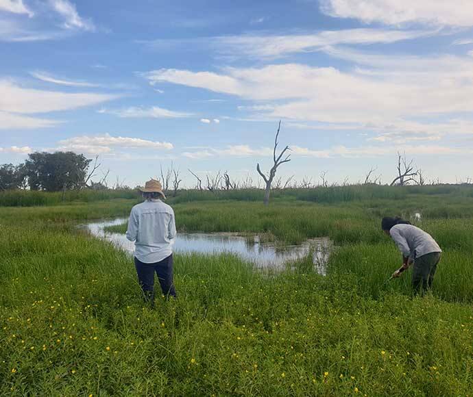
In 2022–23, environmental water managers worked with stakeholders and the community to deliver flows to support large-scale colonial waterbird breeding. This event was initiated following floodplain flooding in mid- to late-2022.
Water from all environmental sources was accessed this year, including NSW Planned Water, as provided by the Gwydir water sharing plan and Commonwealth Environmental Water Holder allocations. The first of the managed deliveries began in December 2022 and concluded in March 2023. In total, 41,262 ML was delivered to support this event to a successful outcome. The Gwydir Ramsar parcels also benefitted from the floodplain flooding.
The Gwydir Environmental Water Advisory Group and local landholders were provided with regular updates about this watering event as it progressed. Environmental water managers monitored and managed daily water delivery rates of flow to achieve the positive outcome by the season’s end.
Regular waterbird nesting surveys and bird counts were undertaken during the breeding event. Latest estimates of colonially nesting waterbirds are 60,000 nests, with the largest colony around 15,000 nests. Species included:
- nesting Australian white, glossy and straw-necked ibis
- little, intermediate, cattle and eastern great egrets
- little black, little pied and pied cormorants
- royal and yellow-billed spoonbills
- Australasian darter
- white-necked, nankeen night and pied herons.
Non-colonial waterbird breeding was also surveyed, with at least 12 species detected. These included Australasian grebe, Australasian shoveler, black-winged stilt, dusky moorhen, Eurasian coot, great crested grebe, grey teal, hardhead, pacific black duck, pink-eared duck, plumed whistling duck and whiskered tern.
This event adds another generation of waterbirds bred in 2021–22, boosting populations of waterbirds across the Murray–Darling Basin.
Case study: Waterbirds double down for a second breeding season
For a second year in succession, colonial waterbirds have returned to the Gwydir Wetlands to breed on mass, many nesting in their historical breeding locations.
Historical records show that colonial waterbirds once bred more regularly in the Gwydir, in about 7 years of every decade. In terms of the seasonal succession of colonial waterbird breeding, more recent records show that these types of events occurred during the summers of 1995–96, 1996–97 and 1998.
The largest colonial waterbird breeding event in the Gwydir Wetlands took place after major flooding over July to September 1998. During this event 150,000 breeding pairs of straw-necked ibis and 10,000 pairs of intermediate egrets, 15,000 pairs rufous night herons and 15,000 pairs of glossy ibis were recorded.
During the 10 years of drought up to 2010, only small breeding events were recorded in the summers of 2000–01 and 2004–05. It wasn’t until major floodplain flooding from November 2011 to February 2012 that the Gwydir was again swept into life. This flooding, in turn, triggered a large-scale colonial waterbird breeding event, not seen since the 1998 major breeding cycle.
It was another decade until widescale floodplain flooding, during the 2021–22 season, again triggered a large-scale breeding event. At this time, field surveys indicated an estimated 45,000 nesting pairs of colonially nesting waterbirds from 14 species completed their reproduction cycle.
With further floodplain flooding inundating over 275,000 hectares this 2022–23 season, breeding estimates increased to 60,000 nests, with the largest colony around 15,000 nests. In total, 16 colonial waterbird species.
What is clear is that colonial waterbird breeding in the Gwydir is triggered by large-scale floodplain flooding events. With a reduced frequency of these events, the opportunity for colonial waterbirds to breed in the Gwydir is impacted. When they do occur, the ability to support these events with water for the environment is fundamental for the long-term survival of these species and their populations across the Murray–Darling Basin.