Water for the environment is managed to deliver benefits for communities and important environmental assets across New South Wales.
During periods of higher rainfall, we adapt our planning to ensure rivers and wetlands can maximise the opportunity to recover and increase their resilience for future dry times.
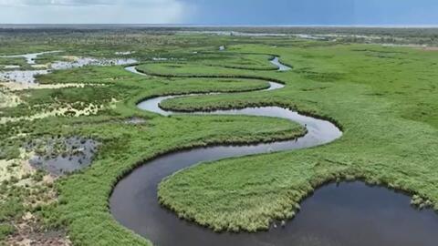
New South Wales is home to a unique array of native plants and animals that rely on our rivers and wetlands to survive the boom and bust cycles that shape the Australian landscape.
Since river regulation, our rivers and floodplains connect less often than is needed to remain healthy.
Water for the environment is a share of the water available in our dams and rivers that is managed to support the ongoing health of local waterways.
Water for the environment is the best available tool that allows us to support the ongoing health of local waterways along with the native plants, animals and local communities that rely on them.
The Department of Planning and Environment is responsible for ensuring that water for the environment is managed in accordance with relevant statutory plans, including water sharing plans established under the NSW Water Management Act 2000 and the Basin Plan established under the Commonwealth Water Act 2007.
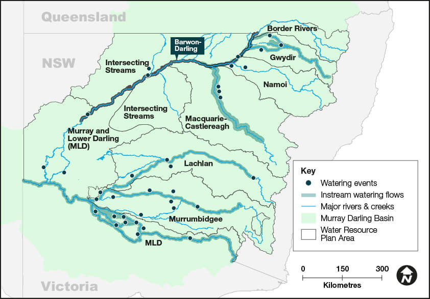
This outcomes report details the work we do in 9 water resource plan areas to support our river systems and meet the needs of native plants, native fish, waterbirds, and other water-dependent wildlife:
- Murray and Lower Darling water resource plan area – 565,260 megalitres delivered to multiple sites in the Murray and Lower Darling catchments
- Murrumbidgee water resource plan area – 385,102 megalitres delivered to multiple wetlands in the Murrumbidgee catchment
- Lachlan water resource plan area – 35,998 megalitres delivered to wetlands, rivers and creeks in the Lachlan catchment
- Macquarie–Castlereagh water resource plan area – 60,708 megalitres delivered to the Macquarie Marshes and Macquarie River
- Gwydir water resource plan area – 15,511 megalitres delivered to watercourses and wetlands in the Gwydir catchment
- Barwon–Darling water resource plan area – 16,867 megalitres protected down the Barwon–Darling watercourse
- Intersecting Streams water resource plan area – 222 megalitres delivered to floodplains in the Intersecting Streams catchment
- Namoi water resource plan area – 4,320 megalitres delivered into the Barwon–Darling watercourse
- Border Rivers water resource plan area.
Executive summary
Maintaining and restoring the health of rivers and wetlands for future generations is the aim of the Water for the Environment program. Our adaptive management approach allows us to focus our efforts on outcomes that can be achieved with the water that’s available in any given year.
In 2022–23, the department's Water for the Environment team managed the delivery of approximately 1,083,988 megalitres of water across 30 delivery events for the environment. This water for the environment was sourced from NSW, Commonwealth, and joint government water accounts and delivered to key sites across the state.
Planning for much of the state was based on a moderate to wet to very wet resource availability scenario. Widespread rainfall and high dam levels provided an opportunity for the program to target enhanced outcomes at sites across New South Wales.
Teams worked to support restoration of habitat to provide feeding, breeding and movement opportunities for native fish, waterbirds and frogs.
In natural flowing rivers we worked with other water agencies to protect some instream flows to provide benefits for communities and the environment.
We continued our work with NSW community-based environmental water advisory groups to prioritise sites to receive water and build on the successes of previous years. We collaborated with numerous landholders, Aboriginal people and community members across the rivers and floodplains where we work. The support and cooperation of stakeholders is critical to the successful outcomes achieved.
Water was used strategically to:
- support water bird health
- support native fish health
- support native vegetation health
- connect and replenish refuge sites, wetlands and rivers.
Murray and Lower Darling – Baaka catchments
In 2022–23 we delivered 565 gigalitres of water to rivers, creeks and wetlands on private and public land. We:
- encouraged the dispersal of golden perch juveniles
- promoted the growth and survival of Murray cod juveniles
- supported several colonial nesting waterbird breeding events
- increased the condition of floodplain river red gums
- successfully supported southern bell frog breeding and recruitment at several private property wetland sites.
Murrumbidgee catchment
In 2022–23 we delivered 385 gigalitres of water to rivers, creeks and wetlands on private and public land. We:
- supported a pelican rookery of around 28,000 nests in the Gayini (Nimmie-Caira) wetlands
- increased the distribution of the endangered southern bell frog and Australasian bittern in the Lowbidgee floodplain
- supported an ibis and spoonbill rookery of about 100,000 nests in the Gayini (Nimmie-Caira) wetlands
- mitigated hypoxic blackwater events in summer to avoid fish deaths in the lower Murrumbidgee and mid-Yanco billabong systems.
Lachlan catchment
In 2022–23 we delivered 36 gigalitres of water to rivers, creeks and wetlands on private and public land. We:
- supported more than 50,000 Australian pelican nests to completion at Lake Brewster for the second consecutive year
- helped restore a more natural wetting cycle for the lower Merrimajeel Creek braided channel floodplain and the culturally significant Dry Lake
- imitated a more natural flood recession in the Lachlan River below Lake Brewster to mitigate water quality and support plants and animals
- provided a small summer fresh below Wyangala Dam to restore connectivity, improve water quality in isolated pools, increase instream habitat and promote recovery after major flood disturbance.
Macquarie–Castlereagh catchment
In 2022–23 we delivered 61 gigalitres of water to rivers, creeks and wetlands on private and public land. We:
- maintained water levels in colonial waterbird colony sites in the Macquarie Marshes
- allowed the movement of native fish from the unregulated Lower Macquarie to the more secure conditions in the regulated mid-Macquarie River
- supported ongoing inundation in the Macquarie Marshes
- maintained flow connection to the Barwon River.
Gwydir catchment
In 2022–23 we delivered 16 gigalitres of water to rivers, creeks and wetlands on private and public land. We:
- supported an estimated 60,000 pairs of colonial nesting waterbirds (16 species) to complete reproduction cycles
- promoted health and resilience in, and fostered reproduction of, wetland and floodplain vegetation communities
- increased intra- and inter-valley connectivity.
Barwon–Darling catchment
In 2022–23 we protected 17 gigalitres of water for the environment in the Barwon–Darling. During this water year we:
- created favourable conditions for native fish recruitment
- improved system connectivity with Menindee Lakes and the Lower Darling – Baaka
- supported periodic inundation of riparian zones and floodplains, improving vegetation condition
- managed flows and inundation of instream and floodplain Aboriginal priority sites.
Intersecting Streams catchment
In 2022–23 we delivered 222 megalitres of water to the western floodplains and worked with partner agencies to coordinate the protection of water for the environment in the Intersecting Streams catchment. During this water year we:
- helped sustain waterbird breeding colonies at Narran Lakes
- improved system connectivity between the Condamine–Balonne and the connected Culgoa–Birrie–Bokhara–Narran system
- improved the condition of wetland vegetation at Narran Lakes
- inundated some core areas of the western floodplain at Toorale National Park and State Conservation Area
- provided connection between the Warrego and Darling Rivers
- inundated significant areas of wetlands along the Paroo River.
Namoi catchment
In 2022–23 we delivered 4.3 gigalitres of water for the environment. During this water year we:
- provided connectivity between the Namoi catchment and Barwon–Darling rivers
- adopted a ‘watching brief’ to identify whether intervention with environmental flows would be required.
Border Rivers catchment
In 2022–23 no deliveries of water for the environment were made. During this water year we monitored the catchment and put plans in place to support environmental outcomes, but rainfall and natural flows were able to meet the needs of the catchment.
A year in the catchments
Monitoring, evaluation and reporting update
The Water for the Environment Monitoring, Evaluating and Reporting (MER) Program measures ecological responses to the delivery of water for the environment. It does this by tracking indicators of river and wetland health across 4 environmental themes:
- river flows and connectivity
- native vegetation
- waterbirds
- frogs.
By monitoring changes in the condition, abundance and distribution of these indicators, we can measure progress towards meeting long-term water plans and Basin Plan objectives. We are also able to continually improve how we deliver water for the environment by increasing our understanding of how river and wetland systems respond to flow and flooding regimes.
Our monitoring efforts focus on wetlands that receive water for the environment, including the Gwydir Wetlands, Macquarie Marshes, Lower Lachlan Wetlands, Lowbidgee Floodplain and the Millewa Forest. We also extended our monitoring efforts to the Narran Lakes.
We measure changes in inundation extent and duration of floodplain wetlands, vegetation condition and extent, and changes in waterbird and frog populations in response to water for the environment.
We use a variety of approaches to determine whether water for the environment is meeting the needs of our river and wetland systems. These include:
- satellite imagery to track inundation and flooding regimes
- depth loggers to understand inundation patterns, including duration
- aerial and ground surveys of waterbird populations
- vegetation mapping using high-resolution imagery
- on-ground surveys of plant species composition
- acoustic recordings and observation to monitor frogs
- environmental DNA to determine the presence of cryptic or threatened species.
We partner with other agencies, including the Commonwealth Environmental Water Holder (CEWH), to collaborate with their MER providers including independent researchers, tertiary institutions, and community groups to improve our understanding through complementary monitoring programs.
We also work closely with the Department of Planning and Environment, NSW Department of Primary Industries – Fisheries, and the Murray–Darling Basin Authority (MDBA) through The Living Murray (TLM) program.
We report our findings to the MDBA to meet Schedule 12 requirements of the Basin Plan. Schedule 12 includes annual reporting of ecological outcomes at an asset-scale (Matter 9.3) and a 5-yearly evaluation (Matter 8), which is due in 2024.
We provide regular updates to the community through our website and stakeholder engagement.
The year in review
Continuing La Niña conditions and rainfall across the NSW Murray–Darling Basin resulted in widespread areas of inundation. These conditions kept storage levels high and provided full allocations of both planned and held environmental water, allowing water to be delivered to river and wetland habitats. Water for the environment enhanced river and wetland connectivity to support native vegetation, waterbird and frog breeding, native fish migration and recruitment.
River flows and connectivity
In 2022–23, natural river flows inundated extensive areas of floodplain, including critical flood-dependent habitats such as non-woody wetlands, lignum shrublands, as well as the forest and woodland communities of river red gum, coolibah and black box.
We used satellite imagery to measure inundation extents at major wetlands:
- Gwydir wetlands (including Mallowa Creek and Mehi River): almost 279,586 hectares were inundated in total, including 82% (82,280 hectares) of flood-dependent habitat.
- Macquarie Marshes: 248,634 hectares were inundated, including 99% (105,939 hectares) of flood-dependent habitat.
- Lower Lachlan: 345,548 hectares were inundated, including 81% (233,154 hectares) of flood-dependent habitat.
- Lowbidgee floodplain: 241,733 hectares were inundated, including 90% (159,262 hectares) of flood-dependent habitat.
- Millewa Forest: 64,487 hectares were inundated, including 96% (32,428 hectares) of flood-dependent habitat.
This increased the area of habitat availability for waterbirds and frogs and supported wetland vegetation.
Waterbird surveys
Extensive colonial waterbird breeding continued across the NSW Murray–Darling Basin in 2022–23.
A variety of waterbird species bred extensively across major wetland complexes in the Macquarie, Narran, Gwydir, Lachlan, Lowbidgee and mid-Murray. This second ‘bumper’ waterbird breeding season provided a much-needed boost for waterbird populations. Despite this, the long-term Eastern Australian Waterbird Survey continues to demonstrate the ongoing decline of populations across many waterbird species.
For the second consecutive year, colonial waterbird breeding events dominated the waterbird monitoring effort across the department in collaboration with partner agencies and the University of NSW (UNSW). Water levels and water quality were actively managed by environmental water managers to support reproductive success. We used on-ground and aerial methods, undertaken under appropriate scientific and ethics approval, to count nests and species, assess colony health and water levels.
In response to the continuing wet conditions, Narran Lakes, near Brewarrina in north-west NSW, experienced follow-up colonial waterbird breeding after a successful 2021–22 season. Large breeding colonies of straw-necked ibis and pelicans were recorded as well as nesting royal spoonbills, little pied cormorants and Australasian darters.
Natural and managed environmental flows supported 16 species of waterbirds and around 60,000 nests in the Gwydir during the 2022–23 water year.
In the Macquarie Marshes, large numbers of breeding waterbirds congregated, with more than 197,000 colonial waterbird nests counted. We also observed magpie geese in the Gwydir and Macquarie.
In the Lachlan, water for the environment facilitated ideal breeding conditions for pelicans at Lake Brewster. We identified more than 50,000 nests at the lake, making it one of the largest events on record. Monitoring also revealed successful colonial waterbird breeding events across the lower Lachlan.
Wetlands in Gayini supported a large ibis and spoonbill rookery of approximately 100,000 nests. A large pelican breeding event was also supported in the Lowbidgee, with around 28,000 pelican nests reported across the Gayini (Nimmie-Caira) wetlands. Australasian bitterns were heard calling at sites across the Lowbidgee.
A high volume of the endangered Australasian bittern was heard calling in vegetated wetlands in the Barmah–Millewa Forest late in the breeding season. Successful colonial waterbird breeding occurred at other locations in the Barmah–Millewa Forest and Edward–Kolety–Wakool area.
The large numbers of breeding pelicans across New South Wales saw 1,200 young birds fitted with coloured leg bands, indicating where the pelican had hatched. Orange bands have been attached to juvenile pelicans bred at Lake Brewster in the Lachlan since 2017. In 2021–22, researchers began banding young pelicans with blue bands at the Gayini Wetland in the Lowbidgee. This year, 400 juvenile pelicans received black bands at Narran Lake in north-west New South Wales. DCCEEW and UNSW researchers are trying to better understand nest-site fidelity, which is the tendency for birds to return each season to the same nesting site. Members of the community are asked to report sightings to support the Lake Brewster pelican banding project and help researchers better understand pelican breeding preferences and hopefully help declining pelican populations.
Intensive monitoring of waterbird breeding colony sites is vital for seasonal adaptive management of environmental water deliveries.
Frog surveys
During the 2022–23 spring–summer, natural inflows and the delivery of water for the environment provided wetland habitat for frogs and supported frog breeding across many monitored sites.
Surveys in the southern NSW Basin indicated that the endangered southern bell frog, one of Australia’s largest frog species, was supported with water for the environment in partnership with local landholders. Our team worked with Saving our Species, CEWH and NSW National Parks and Wildlife Service to deliver water to priority wetlands to support frog breeding over summer.
In the Murrumbidgee, a large number of southern bell frogs were detected at sites around Coleambally and the Lowbidgee. The endangered species was also recorded calling and breeding on private properties in the mid-Murray. Breeding success was also observed in the lower Lachlan where the southern bell frog was recently rediscovered.
Frog surveys in the Northern Basin indicated that flow-dependent frog species such as the spotted marsh frog, eastern sign-bearing froglet, barking marsh frog, Peron’s tree frog, broad-palmed frog and salmon-striped frog, were found across many of our monitoring sites. The number of juveniles identified across the sites indicated frog breeding was widespread over the 2022–23 summer period. We also detected tree-dwelling frogs such as the green tree frog and desert tree frog.
Water holdings and trade
The Department of Planning and Environment is the lead agency for the delivery of water for the environment in New South Wales. This includes collaboration on the delivery of Commonwealth water held by the Commonwealth Environment Water Holder.
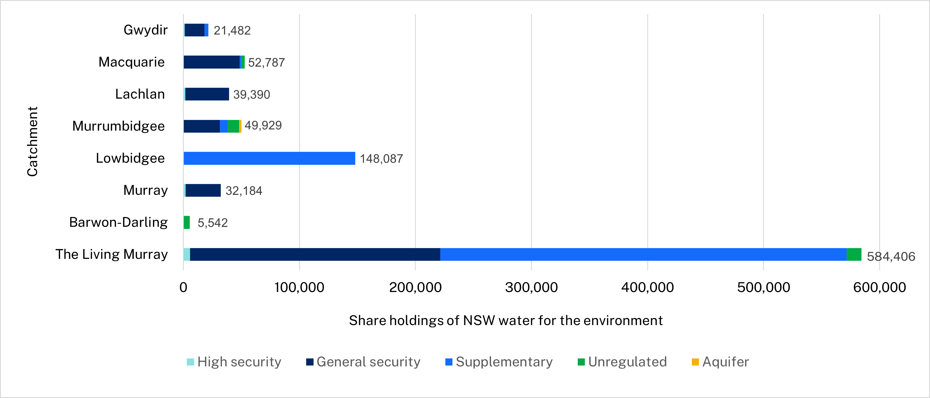
This chart summarises current water holdings, or state ‘held’ water for the environment, recovered to 30 June 2023 (megalitres).
Water trade
The department uses the water market to:
- move water to where it is needed most
- help pay water-use licence fees
- support small infrastructure projects to improve environmental outcomes.
Trades typically commit less than 5% of the water available to the environment and are a small proportion of the total trades made by other market participants. In 2022–23, a total volume of 14,439 megalitres of surface water was sold across all catchments and an additional 2,000 megalitres of Murrumbidgee ‘event based’ supplementary water. Small volumes of groundwater allocation were also sold.
More information about water trade announcements and reporting is available.
Partners
We work with a range of partner agencies, organisations and individuals to achieve/secure effective and efficient delivery of water to our rivers and wetlands.
These include:
- Department of Primary Industries – Fisheries
- Department of Planning and Environment
- Southern Connected Basin Environmental Water Committee
- Northern Basin Aboriginal Nations
- environmental water advisory groups
- Aboriginal peoples
- Murray Lower Darling Rivers Indigenous Nations
- Murray–Darling Wetlands Working Group
- field naturalists and bird-watching community groups
- landholders
- recreational fishers
- universities
- Murray–Darling Basin Authority
- Commonwealth Environmental Water Holder.
More information about some of our partner agencies is available on our terms and definitions webpage.