Catchment connectivity, waterbird breeding and native plants were the focus of environmental flows in the Lachlan in 2022–23.
Key outcomes
Under very wet conditions, environmental water managers worked with partner agencies and stakeholders to coordinate the delivery of water for the environment to:
- support more than 50,000 Australian pelican nests to completion at Lake Brewster for the second consecutive season
- contribute to restoring a more natural ‘wetting’ cycle for lower Merrimajeel Creek braided channel floodplain, and the locally and culturally significant Dry Lake
- mimic a more natural flood recession in the Lachlan River below Lake Brewster to mitigate risks to water quality and biota from a sudden and sharp drop in river levels during summer
- provide a small summer fresh below Wyangala Dam to restore longitudinal connectivity and improve water quality in isolated pools, increase instream habitat, and promote recovery post major flood disturbance
- repurpose the Wyangala small summer fresh to benefit small-scale bird breeding in Wallamundary Creek and mitigate risks to fish from a reported algal bloom below Brewster Weir.
Catchment conditions
During the 2022–23 year the Lachlan catchment experienced very wet La Niña weather conditions for the third consecutive year. The full 350,000 megalitres (ML) of translucent flow was delivered past Lake Brewster Weir from 29 May to 29 July 2022.
The largest flood release on record from Wyangala Dam in November 2022 (>260,000 ML daily release), combined with local rainfall, led to record levels of system-wide wetland and floodplain inundation.
Water for the environment was managed primarily to:
- maintain lateral connectivity of floodplain inundation in the lower Lachlan distributary creeks prior to arrival of upstream flood flows
- support pelican breeding
- mitigate the risks of poor water quality and lack of in-stream habitat for water-dependent biota, including native fish, due to sudden, sharp falls in river levels from capturing all flows into storages.
About the catchment
The Lachlan catchment is in central western New South Wales, covering an area of 90,000 square kilometres. Climatic zones of the Lachlan catchment vary markedly as it flows from the headwaters and tablelands in the east through the slopes of the middle catchment, to the flat, western plains.
The major river is the Lachlan with nearly 1,300 kilometres of the 1,400-kilometre river regulated by water storages, of which Wyangala Dam is the largest at 1,220 gigalitres (GL). It starts as a chain of ponds near Gunning and ends in the Great Cumbung Swamp. The Lachlan River only flows through to the Murrumbidgee when both rivers are in flood.
The Lachlan catchment is characterised by alluvial floodplains and distributary creek systems. It maintains some of the most diverse assemblages of wetland habitats, some only found in this catchment. Important sites include the Booligal Wetlands, Lake Brewster, Lake Cowal, Great Cumbung and Lachlan swamps, all of which are wetlands of national significance.
Water for Country
The Lachlan is Country to the Wiradjuri, Nari Nari, Mutthi Mutthi, Ngiyampaa and Yita Yita Aboriginal peoples.
Water for Country is environmental water use planned by the Department of Planning and Environment and Aboriginal people to achieve shared benefits for the environment and cultural places, values and/or interests.
In the 2022–23 water year in the Lachlan catchment, widespread flooding provided an opportunity for environmental water managers to listen and learn from Aboriginal peoples about the healing power of water on Country. Responding to the call for water in the Galaridyi Bangamalagi: Sharing the Lachlan River film by Uncle Ray Budyaan Woods and Bernard Sullivan, water was delivered to the lower Merrimajeel floodplain.
Watering aims
Under a predicted moderate to wet resource availability scenario, the Lachlan Environmental Water Advisory Group developed its Annual environmental water priorities in the Lachlan catchment 2022–23. Aims for the use of water for the environment were to:
- extend inundation of river red gum, black box and lignum floodplain wetlands in the lower Lachlan distributary creeks (Willandra, Merrowie and Merrimajeel creeks)
- provide high-quality habitat for waterbird breeding, foraging and dispersal
- support colonial waterbird breeding events at multiple rookery sites as they occur
- extend longitudinal and lateral connectivity from translucent or tributary flows in the Lachlan swamps and Great Cumbung region
- promote seed setting and establish inflow wetland at Lake Brewster.
Under very wet conditions, environmental water managers achieved all aims, with the exception of establishing a Lake Brewster inflow wetland. Working with natural cues and flows, key floodplain and wetland connections were enhanced, providing opportunities for plants and animals to breed, move and thrive.
Water delivery
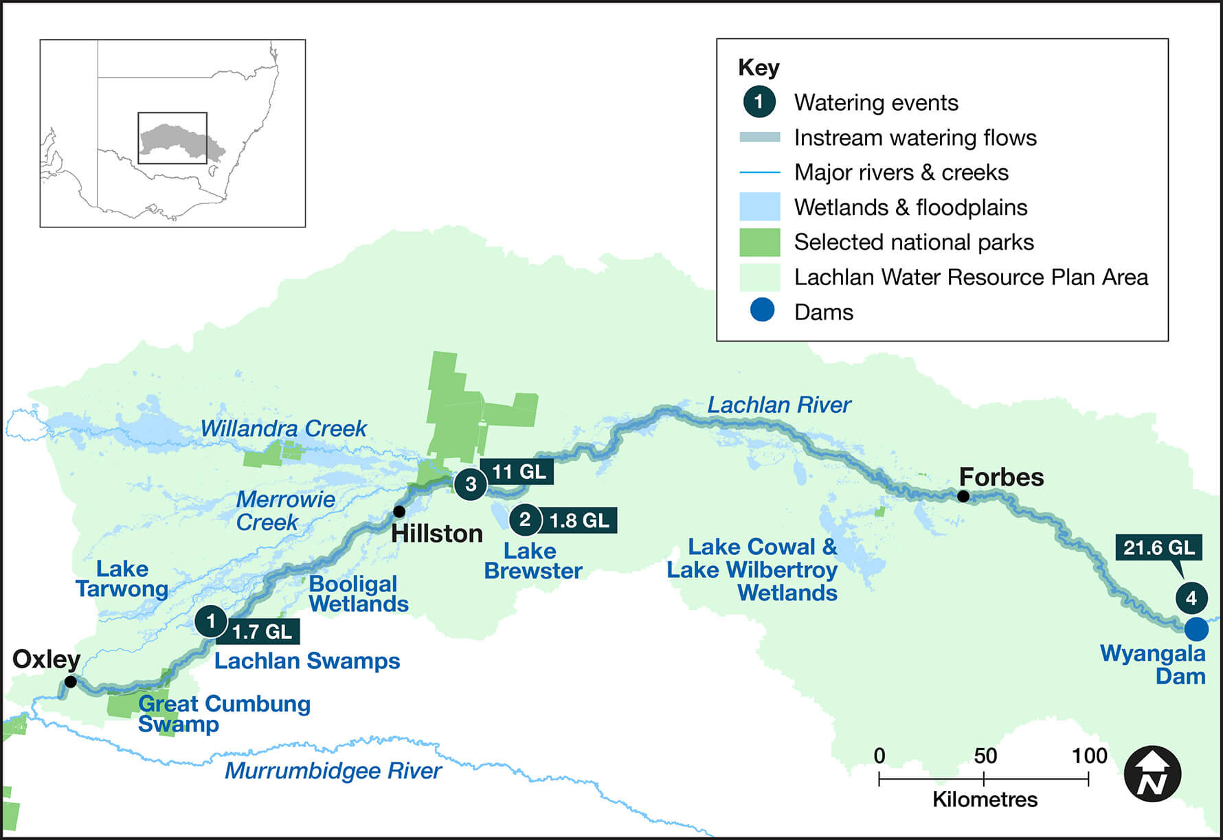
This table and chart provide a summary of 35,998 megalitres of water for the environment delivered in the Lachlan catchment during the 2022–23 watering year. A further 350,000 megalitres of translucent flows were also delivered bridging the end of the previous water year and start of the 2022–23 water year. The catchment experienced record spring–summer rainfall events.
Figures were accurate at the date of publishing, but maybe adjusted. Watering event numbers in the table and bar chart relate to location numbers marked on the map.
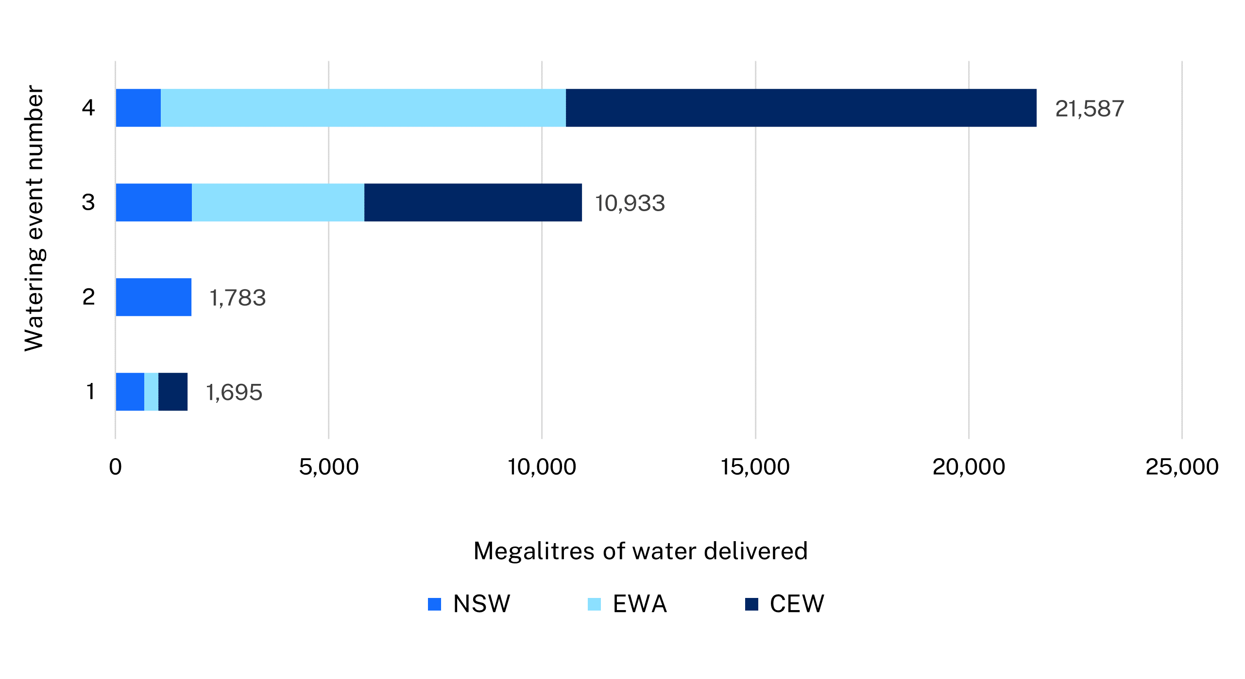
Notes: CEW = Commonwealth licensed environmental water; EWA = environmental water allowance accrued under the Water Sharing Plan; NSW = NSW licensed environmental water; TLM = The Living Murray.
| Watering event number | Location | Outcomes | Start date | Finish date |
|---|---|---|---|---|
| 1 | Lower Merrimajeel Dry Lake pumping | Waterbirds Connectivity Vegetation | 09 Aug 2022 | 08 Oct 2022 |
| 2 | Lake Brewster pelicans | Waterbirds | 17 Feb 2023 | 10 Mar 2023 |
| 3 | Lower Lachlan flood recession | Native fish Connectivity | 26 Feb 2023 | 13 Mar 2023 |
| 4 | Lachlan River summer fresh | Vegetation Native fish Connectivity | 25 Feb 2023 | 16 Apr 2023 |
Outcomes
In 2022–23, NSW environmental water managers worked with the Commonwealth Environmental Water Holder (CEWH), stakeholders and the community to deliver 4 watering actions across the catchment that:
- restored a more natural wetting cycle to the lower Merrimajeel Creek above Dry Lake in autumn when translucent and unregulated flows were uncertain. This reduced the risk of the lower reaches missing out on natural flooding, as had occurred in the past due to major upstream constraints. This was achieved in partnership with Merrimajeel and Muggabah Creek District Trust landholders, a Wiradjuri Elder and landowner, and the CEWH.
- reinstated a more natural flood recession in the Lower Lachlan by preventing all unregulated flows being captured in storages upstream in February 2023. The action improved water quality, mitigated risks to native fish and other in-stream biota from low dissolved oxygen and blue green algal blooms, and potential blackwater risks from floodplain return into a low base river flow.
- provided a system-scale summer fresh from Wyangala Dam in February–March 2023. This flushed and reconnected isolated pools in the upper Lachlan River after a sustained low flow and high-temperature period, following a record dam spill release in November 2022. The action supported a small-scale waterbird breeding event in mid-Lachlan anabranch creeks.
- provided ideal breeding conditions for the largest Australian pelican breeding event for 2 consecutive seasons at Lake Brewster. This was achieved by repurposing a portion of the summer fresh. More than 50,000 nests were monitored for 7 months. Water NSW were key partners, expediting emergency repair works to restore flows into the wetland to maintain influx of local food resources and water levels around the breeding mounds.
- The summer fresh arrived at Willandra Weir after reports of small-scale local fish kills and blue green algal blooms. This mitigated further fish kills by increasing river flow, diluting with better quality water sources and providing refuge for native fish from March to the end of April 2023.
Case study: Dry Lake and lower Merrimajeel floodplain hopes realised
Galaridyi Bangamalagi: Sharing the Lachlan River, is a 2022 film by Uncle Ray Budyaan Woods and Bernard Sullivan that speaks from the heart about the needs of Country.
The NSW Department of Planning and Environment – Environment and Heritage environmental water managers met with filmmakers and a landholder at one of the locations during filming Dry Lake in the lower Merrimajeel Creek. Uncle Ray Budyaan Woods said the film captures the hope to 'see this lake full again' and answer the call of 'these beautiful old box trees that are here crying, actually screaming for water'.
In response, private pumping infrastructure was used for the first time for environmental water delivery in autumn 2022 to enhance natural system flows should they eventuate.
While the goal of filling Dry Lake through this watering action alone was ambitious, pumping New South Wales and Commonwealth environmental water in anticipation of translucent and flood flows would still provide beneficial outcomes. A partial floodplain inundation above Dry Lake would meet several important objectives for in-channel and fringing creek vegetation and provide a productivity ‘flush’ for waterbirds coming into spring.
A total of 1,695 megalitres was delivered from August to October 2022, with the event made possible by the landholder’s daily management.
Flow tracking and inundation analysis confirmed the watering action supported lateral and longitudinal connectivity along the Merrimajeel Creek system. The action provided 76 days and an estimated 500 hectares of additional floodplain inundation, achieving nearly 65% of the target core inundation area of the floodplain above Dry Lake. This provided additional foraging for a nearby waterbird rookery, with an estimated 1,200 nesting straw-necked ibis.
Although the pumping event alone did not reach Dry Lake, and was superseded by the natural flooding, the watering action did achieve the same level of inundation as the 2016–17 flood and in a shorter time. This event has provided valuable learning for environmental water managers for future managed events.
After December 2022, ground access was limited after flooding inundated most of the lower Lachlan floodplain. The department aims to return to Dry Lake and lower Merrimajeel Creek floodplain in winter–spring 2023 to monitor vegetation responses with Wiradjuri and local partners.
Watch the Galaridyi Bangamalagi: Sharing the Lachlan River video.