Native fish, endangered frogs, and iconic river red gums were the focus of environmental flows in 2022–23.
Key outcomes
Under moderate to wet conditions, environmental water managers in collaboration with partner agencies and stakeholders, coordinated the delivery of flows that:
- encouraged the dispersal of golden perch juveniles
- promoted the growth and survival of Murray cod juveniles
- increased the condition of floodplain river red gums
- supported several successful colonial nesting waterbird breeding events
- successfully supported southern bell frog breeding and recruitment at several private property wetland sites.
Catchment conditions
During the 2022–23 year, the Murray and Lower Darling – Baaka catchments experienced La Niña weather conditions, resulting in high rainfall and moderate temperatures. NSW Murray and Lower Darling – Baaka general security entitlements reached full allocation of 110% in October 2022.
Both the Murray and Lower Darling – Baaka catchments experienced many months of high unregulated flows throughout the water year. These flows inundated many priority assets and water for the environment was used at several sites to complement the outcomes achieved by unregulated flows.
About the catchments
The Murray and Lower Darling – Baaka catchments are located in the south and west of NSW and cover a combined area of 98,300 square kilometres.
Located in the temperate climatic zone, average rainfall ranges from nearly 2 metres in alpine areas to less than 300 millimetres in the far west.
The major river in the catchments is the Murray. Australia’s longest river, the Murray starts in the southern alps then receives contributions from several tributaries, including the Ovens and Goulburn rivers that flow from Victoria, and the Murrumbidgee and Darling – Baaka rivers that flow from New South Wales.
Extensive wetland areas are located within the Murray catchment. Ramsar-listed sites include the Millewa, Werai and Koondrook–Perricoota forests, Chowilla Floodplain and River Murray Channel.
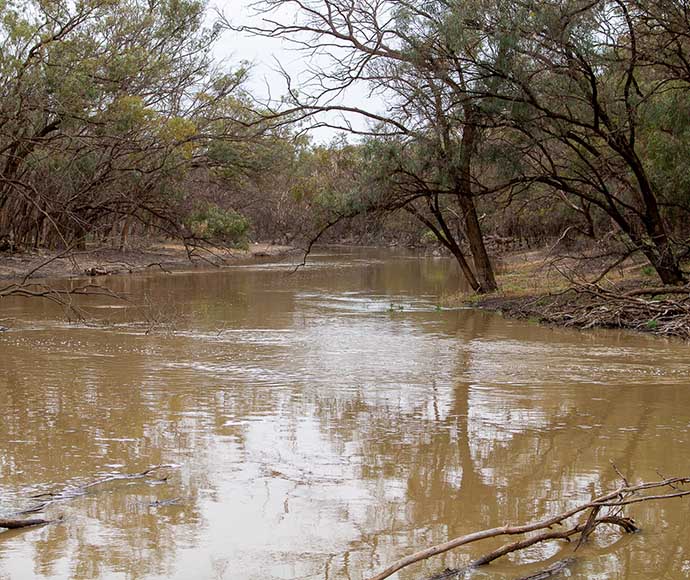
The Murray and Lower Darling – Baaka catchments also contain large river and creek networks – for example, the Edward–Kolety–Wakool system with its extensive red gum forests and black box woodlands.
Water for Country
The Murray and Lower Darling – Baaka catchments are Country to the Wiradjuri, Dhudhuroa, Waywurru, Bangerang, Barapa Barapa, Wamba Wamba, Yorta Yorta, Barkindji-Maraura, Muthi Muthi, Nyeri Nyeri, Tati Tati, Wadi Wadi, Weki Weki and Ngintait Aboriginal peoples.
Water for Country is environmental water use planned by the Department of Planning and Environment and Aboriginal people to achieve shared benefits for the environment and cultural places, values and/or interests. Building relationships with Aboriginal nations will lead to further collaboration for environmental water event planning and complementary projects into the future.
The Murray Lower Darling Rivers Indigenous Nations group is a long-standing member of the Murray and Lower Darling Environmental Water Advisory Group. In 2022–23, environmental water managers delivered water into floodplains, wetlands and waterways including the Murray River and Edward–Wakool–Niemur river system, Werai Forest, Millewa Forest, Koondrook–Perricoota Forest, the Lower Darling – Baaka and Darling Anabranch, and numerous other sites.
Water delivery into these sites was undertaken in partnership with Aboriginal groups and a range of delivery partners, including the Commonwealth Environmental Water Holder, Murray–Darling Basin Authority, a range of NSW and Victorian government agencies, and numerous private landowners and irrigation corporations.
Watering aims
Under a moderate resource availability scenario, the Murray and Lower Darling Environmental Water Advisory Group developed its Annual environmental water priorities in the Murray and Lower Darling Baaka catchments 2022–23. Objectives for the use of water for the environment were to:
- ensure assets maintained their basic functions and resilience
- target small-scale breeding and recruitment for a diverse range of native flora and fauna
- promote low-lying floodplain–river connectivity and support medium-flow river and floodplain functions.
Above average rainfall conditions for much of the catchment saw the resource availability scenario shift from moderate to wet. Environmental water managers adapted their plans to:
- restore key floodplain and wetland linkages
- enhance opportunities for larger-scale breeding and dispersal of several water-dependant fauna species.
Water delivery
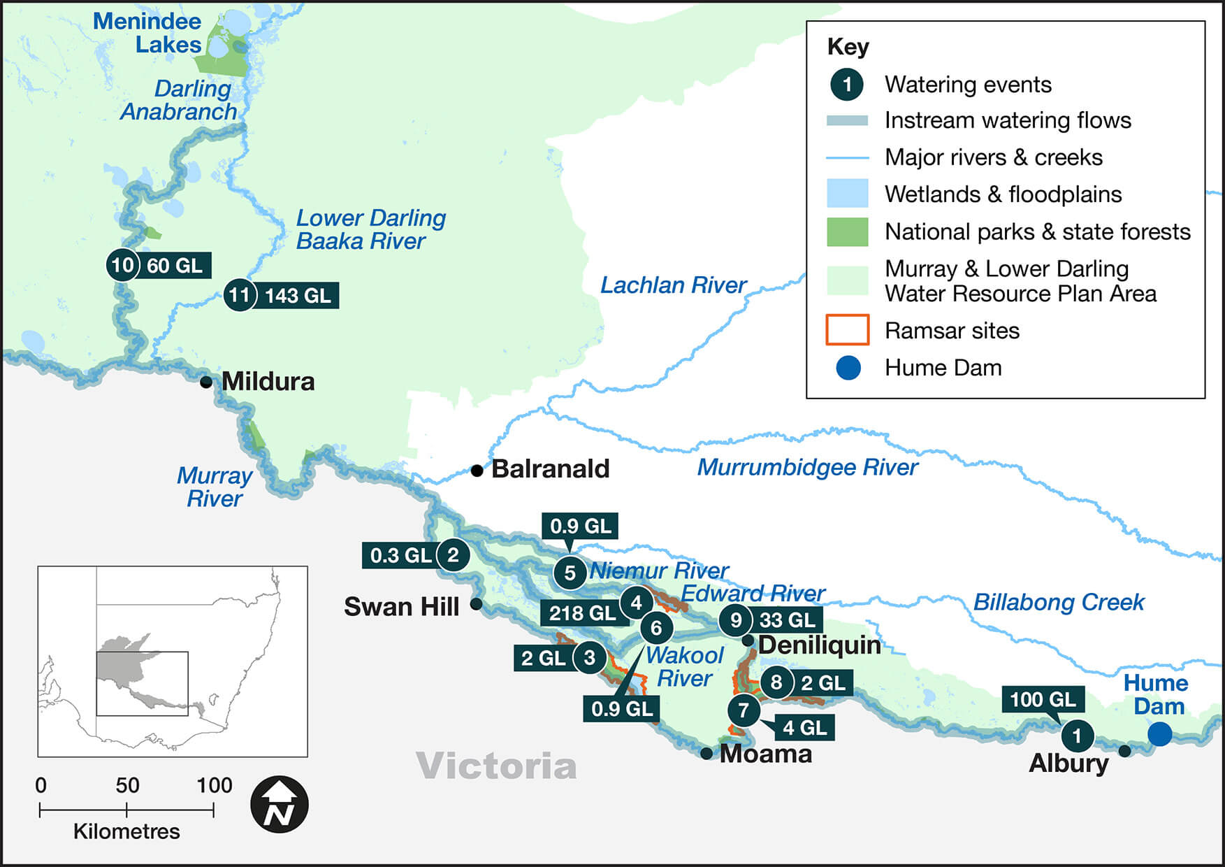
This table and chart provide a summary of 565,260 megalitres (ML) of water for the environment delivered in the Murray and Lower Darling – Baaka catchments during the 2022–23 watering year. There was an additional volume of 251 ML of environmental water delivered in partnership with the Murray Darling Wetlands Working Group.
Figures were accurate at the date of publishing but may be adjusted. Watering event numbers in the table and chart relate to location numbers marked on the map.
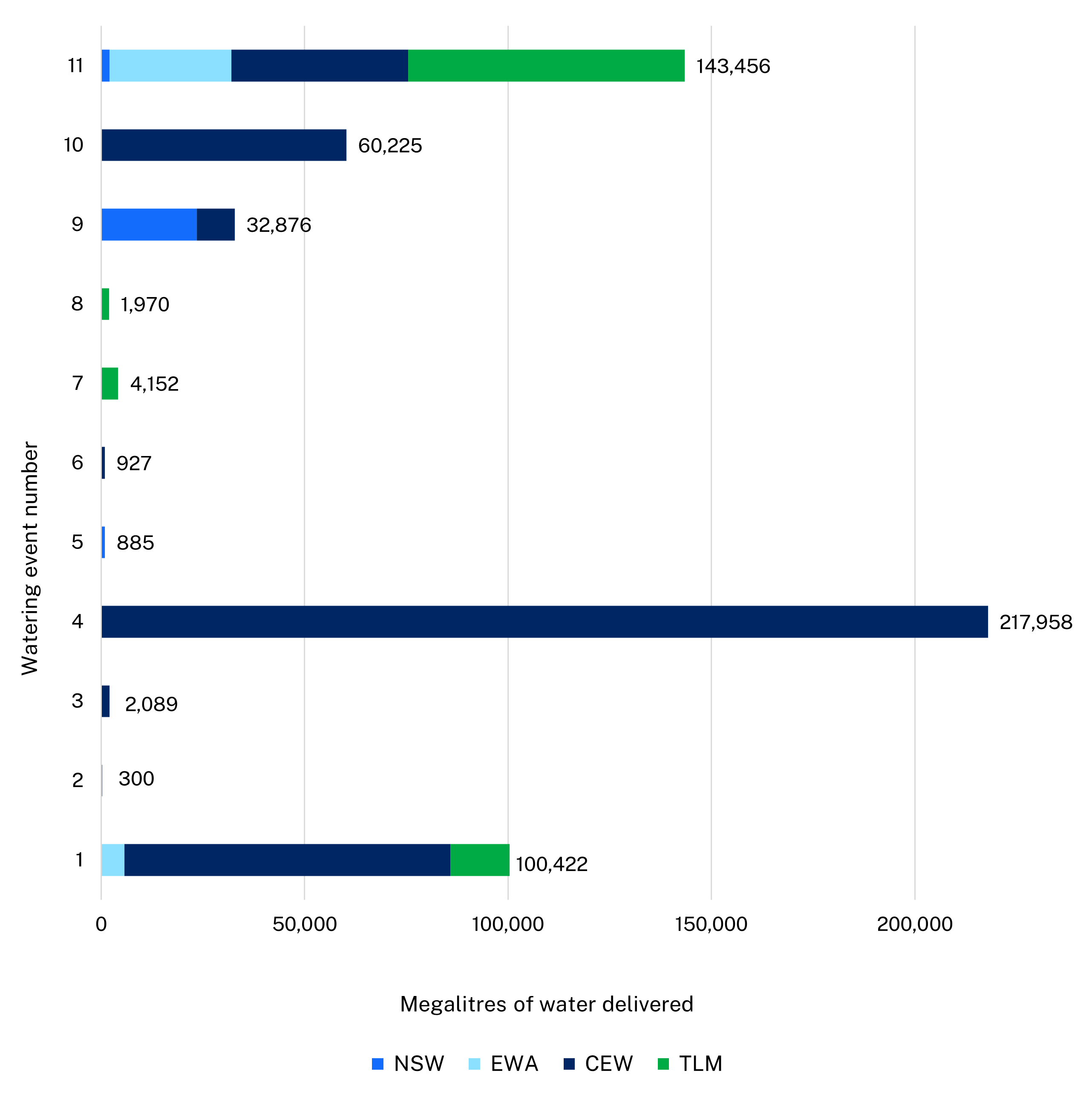
Notes: CEW = Commonwealth licensed environmental water; EWA = environmental water allowance accrued under the Water Sharing Plan; NSW = NSW licensed environmental water; TLM = The Living Murray.
| Watering event number | Location | Outcomes | Start date | Finish date |
|---|---|---|---|---|
| 1 | Murray River multi-site | Connectivity Native fish | 13 Jul 2022 | 30 Jun 2023 |
| 2 | Bingera Creek | Native fish | 18 Jul 2022 | 29 Jul 2022 |
| 3 | The Pollack | Native fish Waterbirds | 27 Jul 2022 | 7 Oct 2023 |
| 4 | Edward–Kolety–Wakool–Niemur escape | Vegetation Native fish | 7 Sep 2022 | 12 Jun 2023 |
| 5 | Mid-Murray private wetland pumping | Waterbirds | 28 Sep 2022 | 21 Mar 2023 |
| 6 | Murray Irrigation area private wetlands | Waterbirds | 01 Nov 2022 | 30 Apr 2023 |
| 7 | Gulpa Creek wetlands | Waterbirds | 22 Dec 2022 | 15 Feb 2023 |
| 8 | Millewa Forest | Connectivity Native fish | 22 Dec 2022 | 31 Jan 2023 |
| 9 | Edward–Kolety–Wakool–Niemur river system | Connectivity Native fish | 13 Jan 2023 | 17 Apr 2023 |
| 10 | Darling Anabranch | Connectivity Native fish | 16 Feb 2023 | 30 Jun 2023 |
| 11 | Lower Darling – Baaka flows | Native fish | 13 Mar 2023 | 30 Jun 2023 |
Outcomes
In 2022–23, environmental water managers worked with stakeholders and the community to deliver flows to 11 assets across the catchment. In many cases, environmental water was delivered to multiple sites within each asset. These environmental flows supported native fish and waterbird populations as well as providing habitat for other species such as the endangered southern bell frog.
Over 100,000 megalitres (ML) of Commonwealth Environment Water Holder (CEWH), The Living Murray and Murray Additional Environmental Allowance was delivered to achieve outcomes in the Murray River and several wetland, river and creek assets between Hume Dam and the South Australian border, including the Barmah–Millewa Forest complex, Edward–Kolety–Wakool–Niemur system and the Werai Forest. This event supported breeding and recruitment opportunities for large-bodied native fish throughout the system, including Murray cod, golden perch and silver perch. Water for the environment provided habitat for colonial waterbird and Australasian bittern breeding in the Barmah–Millewa Forest and improved vegetation condition in the Barmah–Millewa and Werai Ramsar listed forests.
In partnership with Murray Irrigation Ltd (MIL) and several private landholders, DPE – EHG managed the delivery of over 200,000 ML of held NSW and CEWH environmental water through the MIL supply channels, private irrigation outlets and pumps. The program:
- delivered water to creeks and wetlands in the Edward–Kolety–Wakool–Niemur system
- provided critical freshwater refuge for native fish in areas affected by hypoxic blackwater
- provided critical habitat for southern bell frogs
- maintained the condition of hundreds of kilometres of fringing river red gum trees, which would not have had access to flows otherwise
- supported successful colonial waterbird breeding events in several wetlands – at Pollack and in Koondrook–Perricoota Forest 70 pairs of nankeen night herons successfully reared chicks, which were 100% supported by water for the environment.
The Lower Darling Environmental Water Allowance was used for the first time to address critical water quality issues in the Lower Darling – Baaka River at Menindee. Critically low oxygen levels, or hypoxic conditions, resulted in unprecedented numbers of fish dying (an estimated 30 million) in the Menindee town weir pool reach. The majority of dead fish were bony herring, a native species known to ‘boom and bust’ and highly sensitive to changes in water condition. There were also reports of dead golden perch, silver perch, Murray cod and carp. To avoid further fish deaths the provision of flows through the Menindee town weir pool were continued. Water sourced for these flows came from environmental accounts in the absence of any other available water sources.
Case study: Connectivity flows provide dispersal pathways for juvenile golden perch
Throughout the 2022–23 watering season, the Department of Planning and Environment environmental water managers worked collaboratively with the Commonwealth Environmental Water Holder (CEWH), river operators and community to deliver more than 60,000 megalitres of water for the environment down the Great Darling Anabranch (the Anabranch).
The environmental flows were delivered in and around operational ‘spill’ releases to provide a flow corridor for the dispersal of juvenile golden perch from the Menindee Lakes to the River Murray.
Flows in the northern basin supported mass spawning and recruitment of golden perch over the previous 2 years. Monitoring has shown that large numbers of the golden perch recruits move downstream with floodwaters in the Barwon–Darling River into the highly productive Menindee Lakes system. The lakes provide an ideal nursery habitat to support the growth and development of the juvenile fish. Flow deliveries from Lake Cawndilla into the Anabranch provide an opportunity for this iconic native species to migrate from spawning grounds in the northern basin through to the Southern Connected Basin (that is, the River Murray system).
A monitoring program was established to help better understand how environmental flows may be tailored to maximise the dispersal of juvenile golden perch. Managed by DPE – EHG, monitoring was undertaken by Charles Sturt University and DPI Fisheries and co-funded by the CEWH and DPE – EHG.
The monitoring involved tracking the movement of golden perch using acoustic transmitters (fitted to fish) and recordings using receivers deployed strategically along the length of the Anabranch. The aim of this work is to provide information for environmental water managers about how flow deliveries (that is, rates and timing) affect golden perch dispersal and to help inform future management.