Native fish, endangered frogs, and iconic river red gums were the focus of environmental flows in 2021–22.
Key outcomes
Under moderate to wet conditions, environmental water managers in collaboration with partner agencies and stakeholders, coordinated the delivery of flows that:
- encouraged the dispersal of golden perch juveniles
- promoted the growth and survival of Murray cod juveniles
- increased the condition of floodplain river red gums that had not received water since 2016
- supported several successful colonial nesting waterbird breeding events
- successfully supported southern bell frog breeding and recruitment at several private property wetland sites.
Catchment conditions
During the 2021–22 year the Murray and Lower Darling–Baaka catchments experienced La Niña weather conditions resulting in high rainfall and moderate temperatures. NSW Murray and Lower Darling–Baaka general security entitlements reached full allocation of 110% in October 2021.
Both the Murray and Lower Darling–Baaka catchments experienced many months of high unregulated flows throughout the water year. These flows inundated many priority assets and environmental water was used at several sites to complement the outcomes achieved by unregulated flows.
About the catchments
The Murray and Lower Darling–Baaka catchments are located in the south and west of New South Wales and cover a combined area of 98,300 square kilometres. Located in the temperate climatic zone, average rainfall ranges from nearly 2 meters in alpine areas to less than 300 millimetres in the far west.
The major river in the catchments is the Murray. Australia’s longest river, the Murray starts in the southern alps then receives contributions from several tributaries, including the Ovens and Goulburn rivers that flow from Victoria, and the Murrumbidgee and Darling–Baaka rivers that flow from New South Wales. Extensive wetland areas are located within the Murray catchment. Ramsar-listed sites include the Millewa, Werai and Koondrook–Perricoota forests, Chowilla Floodplain and River Murray Channel. The Murray and Lower Darling–Baaka catchments also contain large river and creek networks, for example the Edward–Kolety–Wakool system with its extensive red gum forests and black box woodlands.
Traditional owners
The Murray and Lower Darling–Baaka catchments are Country to the Wiradjuri, Dhudhuroa, Waywurru, Bangerang, Barapa Barapa, Wamba Wamba, Yorta Yorta, Barkindji Maraura, Muthi Muthi, Nyeri Nyeri, Tati Tati, Wadi Wadi, Weki Weki and Ngintait First Nations.
Watering aims
Under a moderate resource availability scenario, the Environmental Water Advisory Group developed its Murray and Lower Darling Baaka Catchments – Water for the environment Annual Priorities 2021–22. Objectives for the use of water for the environment were to:
- ensure assets maintained their basic functions and resilience
- target small-scale breeding and recruitment for a diverse range of native flora and fauna
- promote low-lying floodplain-river connectivity and support medium-flow river and floodplain functions.
Above average rainfall conditions for much of the catchment saw the resource availability scenario shift from moderate to wet. As a result, environmental water managers adapted their plans to:
- restore key floodplain and wetland linkages
- enhance opportunities for larger-scale breeding and dispersal of several species.
Water delivery
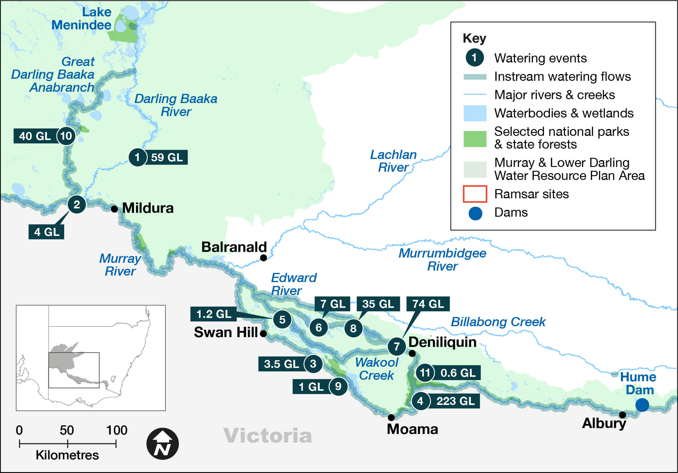
This table and chart provide a summary of 447,762 megalitres (ML) of water for the environment delivered in the Murray and Lower Darling–Baaka catchments during the 2021–22 watering year. There was an additional volume of 1,980.8 ML of environmental water delivered in partnership with the Murray Darling Wetland Working Group (1,575.8 ML) and the Commonwealth Environmental Water Holder (405 ML). Figures are accurate at the date of publishing, but maybe adjusted. Watering event numbers in the table and chart relate to location numbers marked on the map.
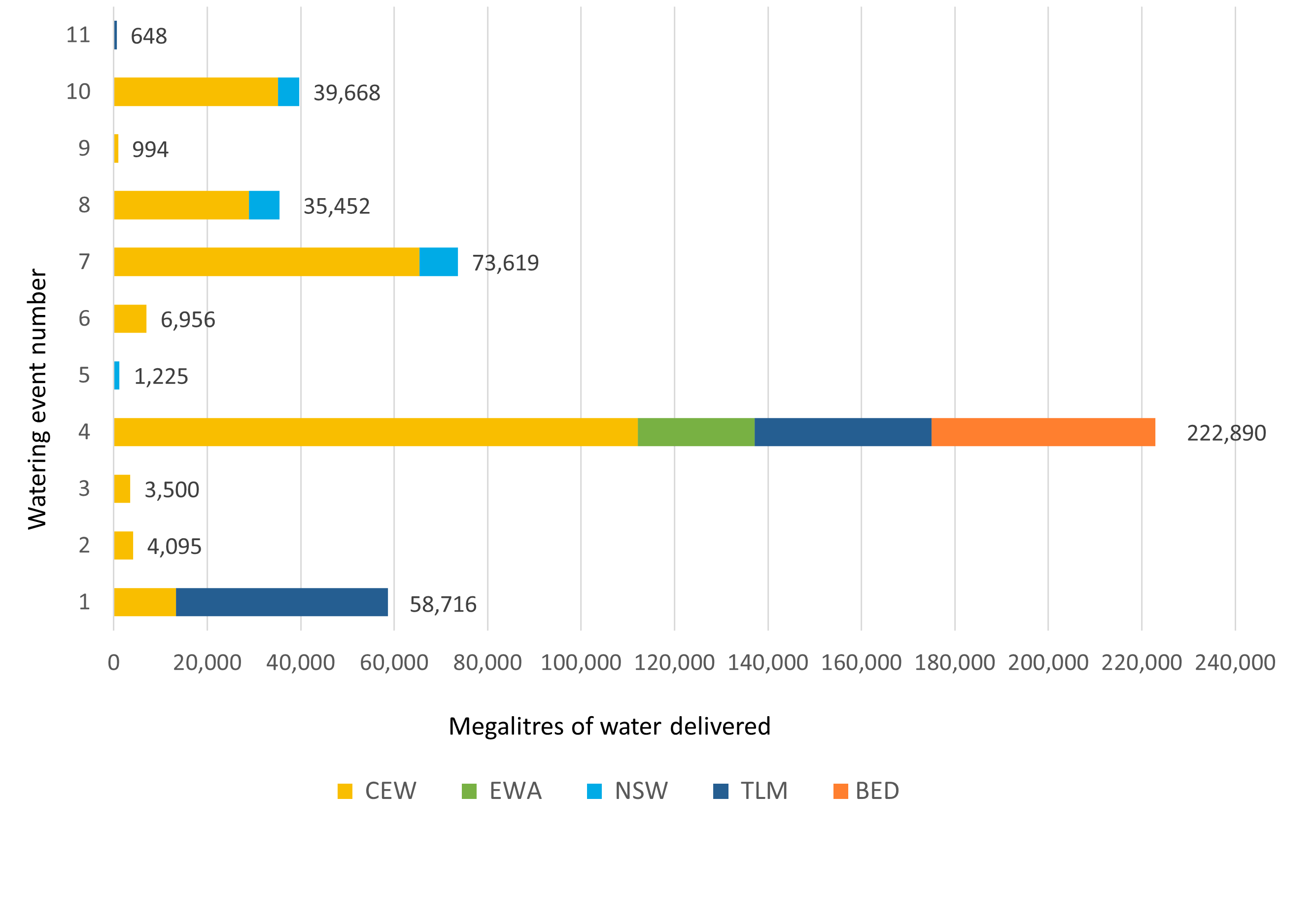
Notes: BED = bulk entitlement delivery; CEW = Commonwealth licensed environmental water; EWA = environmental water allowance accrued under the Water Sharing Plan; NSW = NSW licensed environmental water; TLM = The Living Murray.
| Watering event number | Location | Outcomes | Start date | Finish date |
|---|---|---|---|---|
| 1 | Lower Darling–Baaka | Native fish | 1 Jul 2021 | 25 Oct 2021 |
| 2 | Lower Murray Weir pool variability | Native fish Connectivity | 1 Jul 2021 | 30 Jun 2022 |
| 3 | The Pollack | Waterbirds | 4 Aug 2021 | 10 Jan 2022 |
| 4 | River Murray channel multi-site | Native fish Waterbirds Vegetation Connectivity | 12 Aug 2021 | 30 Jul 2022 |
| 5 | Mid-Murray private wetland pumping | Waterbirds Vegetation | 31 Aug 2021 | 30 May 2022 |
| 6 | Murray Irrigation area private wetlands | Waterbirds | 10 Sep 2021 | 30 May 2022 |
| 7 | Edward–Kolety–Wakool river system | Native fish | 10 Sep 2021 | 30 Apr 2022 |
| 8 | Edward–Kolety–Wakool ephemeral creeks | Native fish Vegetation | 10 Sep 2021 | 8 Jun 2022 |
| 9 | Little Forest | Vegetation | 12 Oct 2021 | 12 May 2022 |
| 10 | Great Darling Anabranch | Native fish | 23 Oct 2021 | 21 Mar 2022 |
| 11 | Millewa Forest | Native fish | 16 Dec 2021 | 22 Feb 2022 |
Outcomes
In 2021–22 environmental water managers worked with stakeholders and the community to deliver flows to more than 20 assets across the catchment. These environmental flows supported native fish and waterbird populations as well as providing habitat for other species such as the endangered southern bell frog.
In partnership with multiple federal and state agencies, we managed the delivery of approximately 149,997 megalitres of The Living Murray and Commonwealth Environmental Water Holder (CEWH) held environmental water, together with 72,893 megalitres of planned environmental water (Environmental Water Allowance and Barmah–Millewa allowance). This water achieved outcomes in the Murray River channel and several wetland, river and creek assets along the Murray between Hume Dam and the South Australian border, including the Barmah–Millewa forest complex, Edward–Kolety–Wakool system and the Werai forest. This water event provided breeding and recruitment opportunities for large bodied native fish including Murray cod, golden perch and silver perch throughout the whole system. The event also provided habitat for colonial waterbird breeding events that occurred in the Barmah–Millewa forest and improved vegetation condition in this forest.
In partnership with Murray Irrigation Ltd (MIL) and several private landholders, we managed the delivery of over 100,000 megalitres of NSW and CEWH held environmental water through MIL channel escapes, private irrigation outlets and pumps. The program:
- delivered water to creeks and wetlands in the Edward–Kolety-Wakool region
- provided critical habitat for native fish and southern bell frogs
- maintained the condition of hundreds of kilometres of fringing river red gum trees which would not have had access to flows otherwise.
Some of these wetlands supported successful colonial waterbird breeding events. For example, 70 pairs of nankeen night herons successfully reared chicks at The Pollack, in Koondrook–Perricoota Forest, which did not receive any natural high flows and was 100% supported by environmental water delivery.
Case study: Golden fish from the Darling–Baaka
Throughout the 2021–22 watering season we worked collaboratively with Water NSW, river operators and community members to manage the delivery of more than 90,000 megalitres of NSW, The Living Murray and Commonwealth Environmental Water Holder (CEWH) environmental water. Flows were delivered in and around operational releases down the Lower Darling–Baaka and the Great Darling Anabranch.
Following a severe drought in the northern basin from 2017 to 2020, the Darling–Baaka river ceased to flow. Most of it dried back to small, isolated pools which resulted in significant fish kills in the 2018–19 summer. With the return of flows from the northern basin in 2020–21, native fish recovery has been the primary focus of environmental water management in the Lower Darling-Baaka.
Starting in September 2021, water for the environment was used to maintain stable flow rates that were high enough to inundate cod nesting snag sites, while minimising drops in river level and associated risk of cod nest disturbance. From November 2021 to the end of the season, the need for environmental water releases into the Lower Darling–Baaka was exceeded by operational releases to manage Menindee storage volume levels as they exceeded 100% capacity. Full storage volumes presented an opportunity to deliver flows down the Great Darling Anabranch (the Anabranch) for the first time since 2017. Flows into this system began with operational releases in October 2021, followed by water for the environment to ensure flows connected to the Murray.
Flows in the northern basin and refilling of the Menindee lakes has supported mass spawning and recruitment events of golden perch. Previous monitoring has shown that many of the golden perch in the Murray system originate from the Darling–Baaka. Therefore, deliveries from Lake Cawndilla down the Anabranch and from the Menindee Lakes via the Lower Darling–Baaka provide an opportunity for golden perch dispersal from the Menindee Lakes system to the Murray.
We are leading a CEWH-funded monitoring program which involves acoustic tagging of golden perch at the top end of the Anabranch and the Lower Darling–Baaka so their movement through these systems can be monitored. This will inform effective delivery of water for the environment in the future.