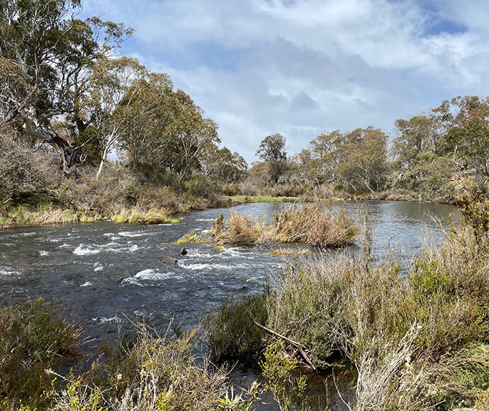
Connectivity along waterways and support for native vegetation, native fish, frogs and other animals were the focus of the pattern of releases for the Snowy and Upper Murrumbidgee rivers in 2021–22.
Key outcomes
Under a wet scenario, environmental water managers worked with partner agencies and stakeholders to coordinate the delivery of water for the environment to:
- provide variable flows to the Snowy and Upper Murrumbidgee rivers, with higher releases during winter and spring typical of snowmelt rivers
- improve the condition of the Snowy River channel and provide suitable habitat for water-dependent animals such as macroinvertebrates and native fish
- provide habitat diversity, suitable habitats and increase resource availability and productivity for water-dependent animals including macroinvertebrates, frogs, platypus, turtles and fish, as well as provide opportunities for breeding and recruitment
- inundate wetlands and ponds to provide breeding opportunities for several native frog species including the whistling tree frog (Litoria verreauxii)
- facilitate connectivity along multiple rivers including the Snowy, Upper Murrumbidgee and Goodradigbee rivers.
Catchment conditions
During the 2021–22 year La Niña weather conditions resulted in the wettest December on record in the Snowy and montane region.
Due to wetter conditions in the southern Murray–Darling Basin, the overall water allocation of 298,677 megalitres (ML) for the Snowy and montane rivers in 2021–22 was significantly higher than the previous water year’s overall allocation of 130,800 ML.
The pattern for releases included higher flow rates over winter, spring and early summer to reflect flow patterns typical of the mixed rainfall and snowmelt river system.
About the catchment
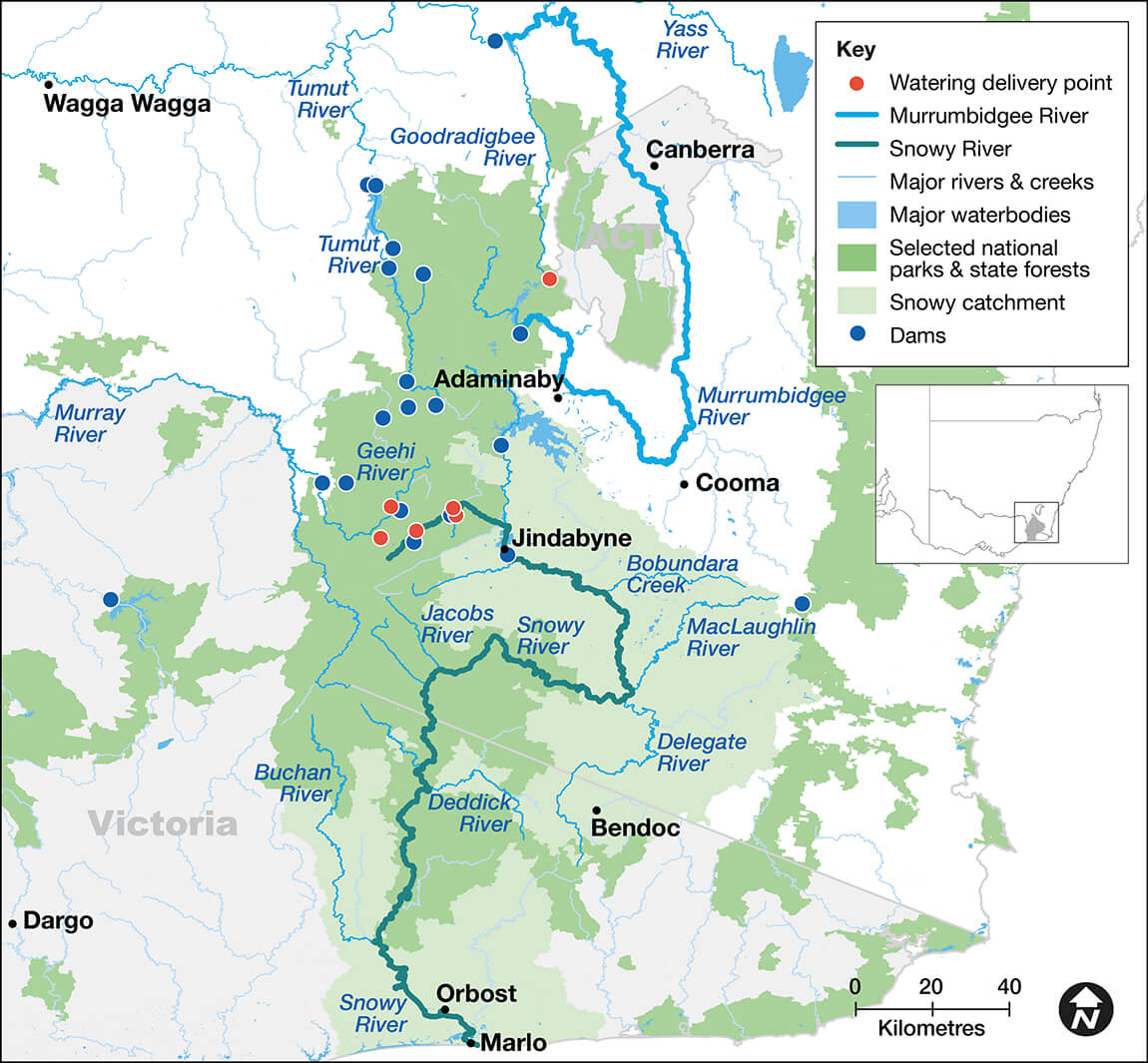
The Snowy River headwaters lie next to those of the Murray and Murrumbidgee rivers, together forming the alpine, sub-alpine and mountain catchments of these major rivers of south-east Australia. The Snowy catchment area totals 15,869 square kilometres and the Upper Murrumbidgee catchment covers 14,000 square kilometres.
The Snowy and montane rivers and tributaries have been diverted in full or part for hydro-electricity generation and irrigation purposes since the 1960s. In 2002, water for the environment releases were initiated in the Snowy River to help protect and restore some of its environmental values.
Unlike other inland river systems, annual daily releases of water for the environment for the Snowy and montane rivers are set before the start of the water year (i.e. May to April). A ‘natural flow scaling’ approach is applied to the Snowy River by using the Thredbo River as a reference. The Thredbo River is a snowmelt river and is a similar size to the modified Snowy River below Jindabyne. Water managers used historical flow data from 1988–89 and 1998–99 for Thredbo River to design releases for the Snowy. A modified natural scaling approach is used for the Upper Murrumbidgee River because there isn’t sufficient environmental water available to release water every day of the year.
Watering aims
Under a wet resource availability scenario, environmental water managers and the Snowy Advisory Committee for the Snowy and montane catchments developed the Annual plan for the Snowy and montane rivers increased flows 2021–22.
Objectives for the use of water for the environment were to:
- provide daily variable flows for the Snowy River and some flow variability for the Upper Murrumbidgee River with higher release rates during winter and spring that are typical of a snowmelt river
- improve the Snowy River channel condition by providing several high flow events to reduce fine sediment and algae smothering, and clean riffles, cobbles and gravel by mobilising sediments
- provide 3 high flow releases in the Upper Murrumbidgee River to flush gravels and cobbles and create better habitat conditions before the Macquarie perch (Macquaria australasica) breeding season
- inundate and connect low-level ponds and slack water areas during late winter and spring, and provide freshes in summer to support breeding and recruitment opportunities for flow-dependent frog species and other native fauna
- provide natural daily flows to targeted montane streams to provide connectivity and maintain ecological functions.
With very wet conditions and high environmental water allocations, environmental water managers provided opportunities for water-dependent native plants and animals to breed and recruit in the Snowy and montane catchments. Natural flow variability and an improvement in the condition of the Snowy River channel were also achieved.
Water delivery
This table provides a summary of 297,335 megalitres (ML) of water for the environment delivered in the Snowy and montane catchments during the 2021–22 watering year.
| Snowy River below Jindabyne flows | Volume allocated | Actual volume | Volume debited |
|---|---|---|---|
| Snowy River increased flows | 201,400 | 200,135 | 200,135 |
| Snowy base flow | 8,500 | 8,500 | 8,500 |
| Jindabyne Dam spill* | – | 84,600 | – |
| Subtotal | 209,900 | 293,235 | 208,635 |
| Snowy montane rivers increased flows | Volume allocated | Actual volume | Volume debited |
|---|---|---|---|
| Tantangara | 31,700 | 31,700 | 31,700 |
| Goodradigbee | 12,000 | 12,600 | 12,000 |
| Middle and Strzelecki creeks | 22,700 | 32,600 | 22,700 |
| Falls Creek | 3,400 | 3,300 | 3,400 |
| Diggers and Tolbar creeks | 18,900 | 29,900 | 18,900 |
| Subtotal | 88,700 | 110,100 | 88,700 |
| Total of Table 1 and Table 2 | 298,600 | 403,335 | 297,335 |
Notes: * There were considerable inflows into Jindabyne Dam with above average rainfall during November 2021 and the highest recorded rainfall in December 2021. This resulted in Jindabyne Dam spilling on 20 December, followed by several pre-releases or controlled spills in December 2021, and January and April 2022. Of the total 84,600 ML of water spilt from the dam, 18,700 ML will be treated as Snowy River increased flows borrow to be repaid from the 2022–23 allocation.
Tributary inflows also resulted in multiple flooding events in the lower Snowy River.
The Snowy montane rivers increased flows (SMRIF) allocation to the Snowy and montane rivers is scaled by a pre-determined gigawatt hour electricity opportunity cost, which is different for each of the river reaches. Except for the Upper Murrumbidgee River, the volume of SMRIF debited is an agreed annual average. Each year the actual flows that pass through the delivery points change subject to the conditions. For example, the volume will be lower in dry years and in wet years, such as 2021–22, the flows will be higher. The Upper Murrumbidgee releases are adjusted as required from Tantangara Dam.
Outcomes
For the 2021–22 water year, 209,877 ML of water for the environment, known as the Snowy River increased flows (SRIF), was allocated for the Snowy River. Forgone electricity generation of 142 gigawatt hours (GWh) was made available for the montane streams, the equivalent to 88,800 ML of water. This is known as the Snowy montane rivers increased flows (SMRIF). The SMRIF includes releases into the Upper Murrumbidgee River.
In 2021–22 environmental water managers worked with stakeholders and the community to deliver water for the environment to 6 rivers and streams across the Snowy and montane catchments. Environmental flows supported river connectivity to improve river health and provided important habitat for water-dependent native plants and animals including frogs, platypus and fish.
The high flows improved the health of the Snowy River by cleaning riffles and flushing sediments.
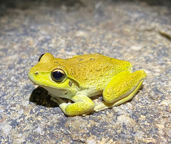
The high flows played a crucial role connecting ponds and small wetlands along the Snowy and Upper Murrumbidgee rivers. Connection of these habitats supported breeding activities for a diversity of frog species. Water managers conducted frog monitoring and found 9 species, including the threatened alpine tree frog, in the Snowy and montane rivers.
The alpine tree frog, a subspecies of the broadly distributed whistling tree frog, is listed as endangered in New South Wales and vulnerable under Commonwealth legislation. This species occurs in alpine and sub-alpine zones or high country in south-eastern NSW and Victoria, usually above 1,100 metres and mostly located within Kosciuszko National Park. The species was found at multiple locations along the Upper Murrumbidgee and connected ponds. Monitoring teams also observed recently metamorphed juvenile frogs in December 2021.
Case study: Snowy River flushing flows
The development of the Snowy Hydro Scheme significantly altered the natural flow regime for the Snowy River. From 1967 to 2002 around 99% of natural flows in the upper Snowy were diverted for power generation and irrigation purposes in the Murrumbidgee and Murray catchments.
Environmental releases first started in the Snowy River in 2002. Environmental water managers designed high and flushing flows to be delivered to encourage scouring and in-channel erosion, with the aim of redefining the heavily sedimented river channel.
The long-term aim of this process is to return the Snowy River to a smaller, healthier montane river. Flushing flows are defined as those exceeding 5,000 megalitres/day and are released from the spillway gates of Jindabyne Dam.
The physical riverbed structure, or geomorphology of the Snowy River channel has been monitored on several occasions since environmental flows commenced in 2002. This monitoring helps water managers understand how the river channel changes over time and whether environmental releases are helping the Snowy River become a healthy system again.
In 2022 the results of a geomorphology study indicated that the river channel is deepening and widening at some locations over time. This suggests that higher environmental releases are having the predicted effect on channel geomorphology. It is expected that if the releases are continued the river will gradually deepen, helping to meet the long-term objective of returning the river towards a more natural flow regime.