Waterbird breeding, native fish movement and endangered frogs were the focus of managed environmental flows in 2021–22.
Key outcomes
Under wet to very wet conditions, environmental water managers worked with partner agencies and stakeholders to coordinate the delivery of water for the environment to:
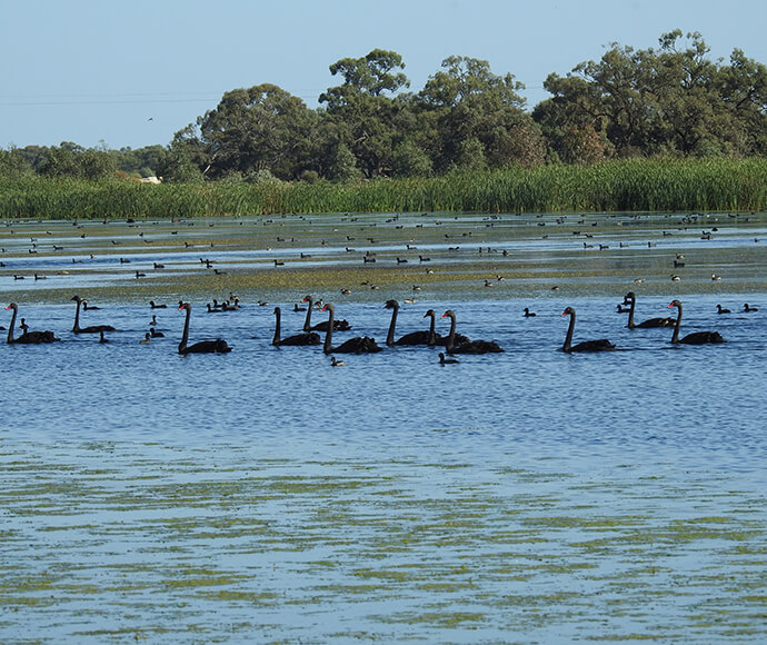
- support the largest ever pelican rookery documented in the Murrumbidgee catchment
- maintain a highly significant ibis and spoonbill rookery in the Gayini (Nimmie-Caira) wetlands of ~20,000 nests
- increase the distribution of the endangered southern bell frog and Australasian bittern in the Lowbidgee floodplain and Coleambally Irrigation Area
- mitigate hypoxic blackwater events in summer to avoid fish deaths in the lower Murrumbidgee and mid Yanco billabong systems
- manage more gradual and natural water recession behind large operational releases to improve fish movement opportunities and minimise riverbank erosion.
Catchment conditions
During the 2021–22 year the Murrumbidgee catchment experienced La Niña weather conditions, resulting in above average rainfall and below average temperatures. The high rainfall resulted in general and high security licences being 100% allocated. Supplementary water was also accessed during unregulated flow events and the release of water from dams to create airspace.
These circumstances created ideal conditions for native fish movement between floodplain, river, and creek environments. The numerous overbank inundation events in the Lowbidgee floodplain combined seamlessly with ongoing environmental water diversions to create ideal conditions for colonial waterbird breeding.
About the catchment
The Murrumbidgee catchment is in southern New South Wales and covers an area of 81,527 square kilometres. Climatic conditions range from alpine in the Snowy Mountains to semi-arid on the Riverina plains. Major rivers are the Murrumbidgee, with connection flowing into the Murray River and occasionally the Lachlan catchment (Great Cumbung area) when both systems are experiencing high flows. The Murrumbidgee catchment comprises 26 storage or diversion structures, 1,690 kilometres of river and surrounding wetlands.
Traditional owners
The Murrumbidgee catchment is Country to the Barapa Barapa, Mutthi Mutthi, Nari Nari, Ngarigo, Ngunnawal, Nyeri Nyeri, Wadi Wadi, Wolgalu, Wamba Wamba, Weki Weki and Wiradjuri First Nations.
Watering aims
Under a wet to very wet resource availability scenario, the Murrumbidgee Environmental Water Advisory Group developed its Murrumbidgee Catchment – Water for the Environment: Annual Priorities 2021–22. Objectives for the use of water for the environment were to:
- provide foraging and breeding habitat for waterbirds in the Lowbidgee
- pump water into key mid-Murrumbidgee and mid-Yanco–Billabong system wetlands
- restore a more natural flow pattern to support native fish populations
- inundate hundreds of mid-Murrumbidgee wetlands
- connect the Lowbidgee lakes via a wetland reconnection flow of up to 250 gigalitres.
With wet to very wet conditions, environmental water managers used adaptive management strategies to restore key floodplain and wetland connections, and enhance opportunities for plants and animals to breed, move and thrive.
High flow conditions reached minor flood levels at some gauges and were ongoing throughout the year due to above average rainfall. The floodplain wetlands of Yanga, North Redbank and the mid-Murrumbidgee were adequately watered without environmental water use. The Gayini (Nimmie-Caira) wetlands and the Western Lakes were the only Lowbidgee floodplain systems that required water for the environment.
Water delivery
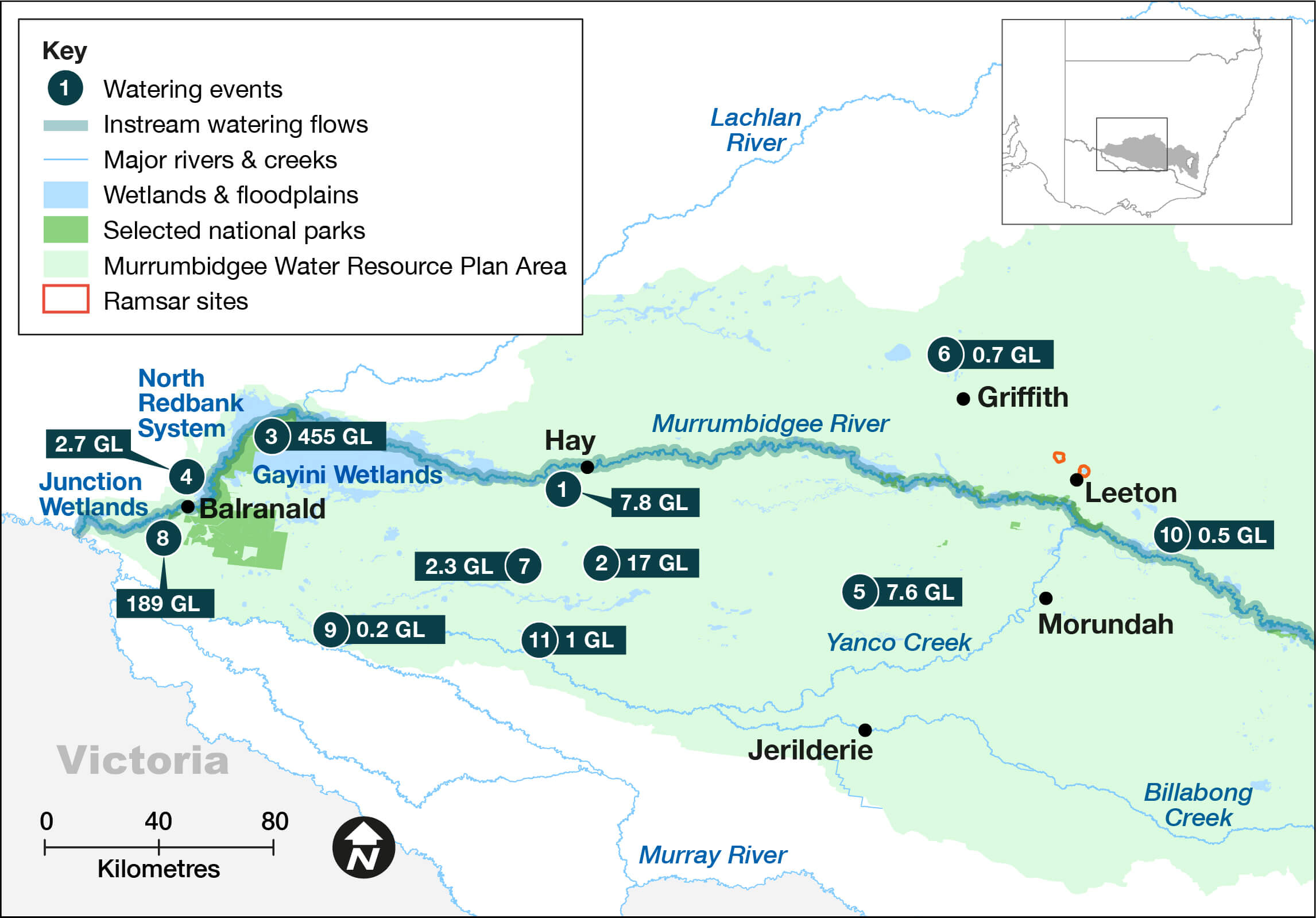
This table and chart provide a summary of 683,669 megalitres of water for the environment delivered in the Murrumbidgee catchment during the 2021–22 watering year. Figures are accurate at the date of publishing, but maybe adjusted. Watering event numbers in the table and bar chart relate to location numbers marked on the map.
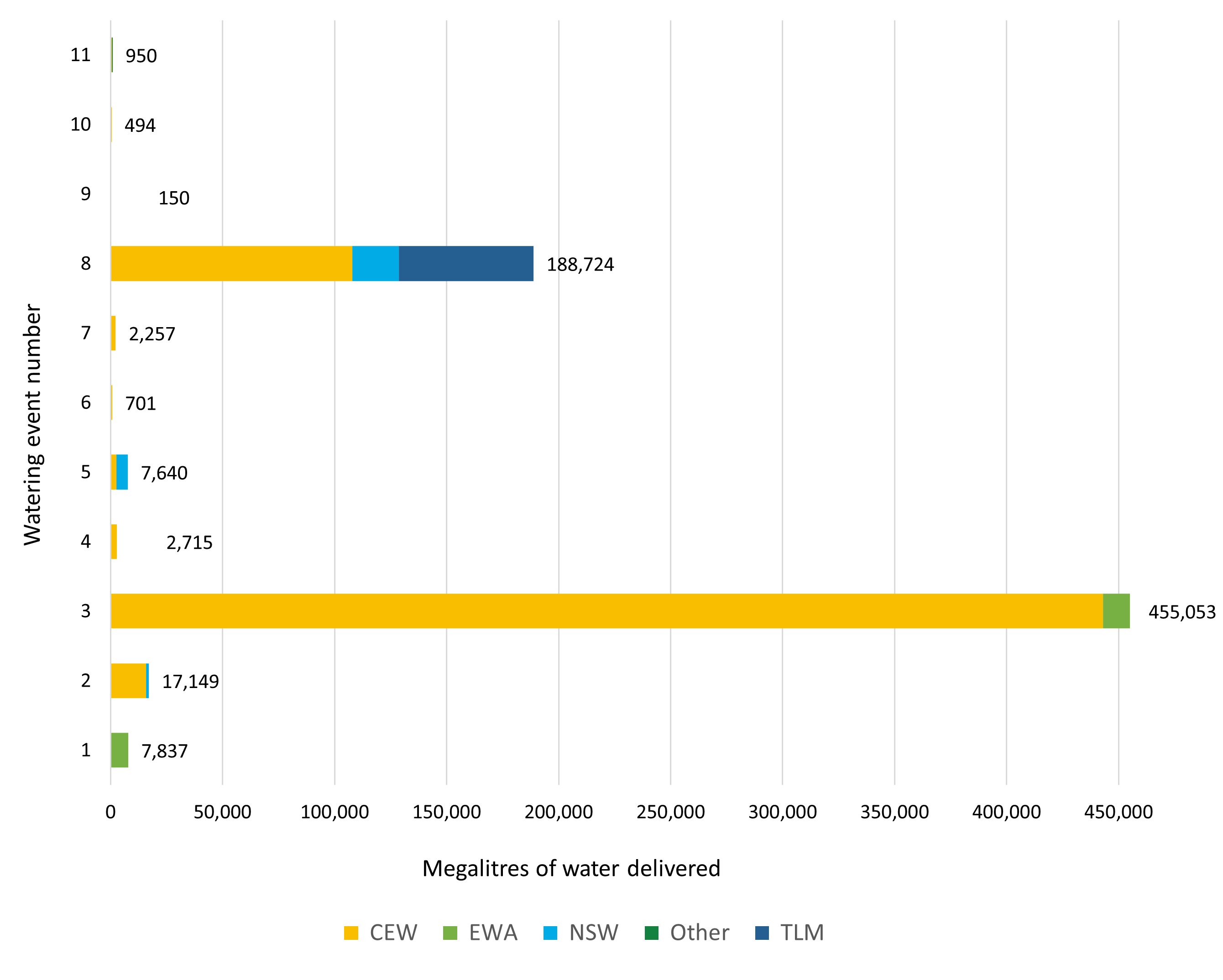
Notes: CEW = Commonwealth licensed environmental water; EWA = environmental water allowance accrued under the Water Sharing Plan; NSW = NSW licensed environmental water; TLM = The Living Murray.
| Watering event number | Location | Outcomes | Start date | Finish date |
|---|---|---|---|---|
| 1 | Murrumbidgee flow peak supplementation | Connectivity | 05 Jul 2021 | 25 Oct 2021 |
| 2 | Yanco, forest and forest anabranch | Waterbirds | 27 Jul 2021 | 31 Mar 2022 |
| 3 | Gayini Nimmie-Caira | Waterbirds | 2 Sep 2021 | 15 May 2022 |
| 4 | Western Lakes | Vegetation | 8 Sep 2021 | 15 May 2022 |
| 5 | Coleambally Irrigation Area Wetlands | Vegetation | 20 Oct 2021 | 17 Apr 2022 |
| 6 | Murrumbidgee Irrigation Area Wetlands | Waterbirds | 28 Oct 2021 | 24 Jun 2022 |
| 7 | Rhyola Wetland and lake complex pumping | Vegetation | 29 Oct 2021 | 6 Jan 2022 |
| 8 | Murrumbidgee native fish recruitment flow | Native fish | 22 Dec 2021 | 30 Jun 2022 |
| 9 | Billamein bell frog wetland watering | Vegetation | 27 Dec 2021 | 11 Jan 2022 |
| 10 | Bundidgerry Creek (Oak Creek, Grass Innes Swamp) | Vegetation | 10 Feb 2022 | 19 Feb 2022 |
| 11 | Middle Wetland (Old Coree) | Vegetation | 12 Apr 2022 | 12 Apr 2022 |
Outcomes
In 2021–22 environmental water managers worked collaboratively with the Nari Nari Tribal Council, Murray–Darling Wetland Working Group and the Commonwealth Environmental Water Holder (CEWH), to deliver 455 gigalitres of Commonwealth and NSW environmental water across the Gayini (Nimmie-Caira) wetlands. This watering event started in early September and extended through to mid-May to support several large colonial waterbird breeding events.
Natural overbank flows also benefited the Gayini (Nimmie-Caira) wetlands with several periods of river and floodplain connectivity before and between environmental water deliveries. Total inundation across the Gayini (Nimmie-Caira) exceeded 53,000 hectares and had a strong influence on waterbird breeding. Waterbird monitoring showed more than 20,000 straw-necked ibis and royal spoonbills nested in the Bala rookery in the east of the Gayini (Nimmie-Caira) wetland system. On the western side of the Gayini (Nimmie-Caira) floodplain about 15,000 pelicans nested in Kieeta Lake.
In partnership with Coleambally Irrigation, private landholders, the NSW Government’s Saving our Species program and the CEWH, 7.6 gigalitres of Commonwealth and NSW environmental water was delivered to prioritised wetlands across the Coleambally Irrigation Area. The endangered southern bell frog was detected at all but one site which received water, with hundreds of southern bell frogs detected at some sites.
Case study: 100-year dry phase
Two endangered species were detected for the first time after New South Wales managed the delivery of water for the environment to the Western Lakes in 2021–22.
In partnership with landholders and the Commonwealth Environmental Water Holder, 3 gigalitres of environmental water was delivered in between several unregulated flood flows.
The initial aim was to allow for continued aquatic vegetation growth and distribution around the rehabilitating Western Lakes system, as well as providing waterbird forage areas.
The detection of endangered southern bell frogs and Australasian bitterns was predicted. The quality of habitat combined with high abundance of these species in the adjacent wetlands to the east, meant that their detection was inevitable.
It is just over 10 years since the first delivery of water for the environment to the Western Lakes (Paika Lake system). The system experienced a 100-year dry phase after human intervention isolated the Western Lakes from natural flood flows.
The installation of a sizable carp screen on the Paika Lake inlet regulator, which excludes large carp from the lake, has resulted in an excellent aquatic plant response and good water quality.
NSW Fisheries is liaising with environmental water managers and Western Lakes landholders to consider the introduction of several locally extinct and threatened native fish species to some of the smaller wetlands in the system in spring 2022.