Habitat health, waterbird breeding and connectivity were the focus of environmental flows in 2021–22.
Key outcomes
Under an expected moderate/wet to very wet conditions, environmental water managers worked with partner agencies and stakeholders to coordinate the delivery of water for the environment that:
- supported an estimated 45,000 pairs of colonially nesting waterbirds (14 species) to reproduce
- promoted health and resilience, and fostered reproduction of wetland and floodplain vegetation communities
- increased intra- and inter-valley connectivity.
Catchment conditions
During the 2021–22 year, the Gwydir catchment was impacted by various climatic conditions including La Niña weather conditions, which produced high rainfall and moderate temperatures. The high availability of water resulted in general security entitlements reaching 150% and 100% of high security entitlement allocations. Significant releases were also made from Copeton Dam, which reached 100% capacity, and several supplementary announcements were made. The resulting wet conditions were ideal for colonial waterbirds to breed.
About the catchment
The Gwydir catchment is in northern New South Wales and covers an area of 25,596 square kilometres. Located in temperate and subtropical climate zones, rainfall is variable across the catchment, with an annual average of 585 millimetres at Moree.
The major tributaries are Copes, Moredun, Georges, Laura, Myall, Halls and Tycannah creeks and Horton River, where the eastern upland creeks (Copes, Moredun, Georges and Laura) mainly flow into the Gwydir River upstream of Copeton Dam. Downstream, on the western floodplain, the main Gwydir River splits into its main distributaries – the Mehi River (south), Carole Creek (north), Lower Gwydir and Gingham Channels (west/central). Breaking off the Mehi River on its southern side are Moomin, Mallowa and Ballin Boora creeks.
The nationally and internationally significant Gwydir wetlands are a near-terminal wetland delta dominated by semi-permanent wetland vegetation in a semi-arid floodplain. The Big Leather (Lower Gwydir) watercourse supports the state’s largest stand of marsh club rush and the Gingham watercourse contains important colonial waterbird breeding habitats.
Traditional owners
The Gwydir catchment is Country to the Gomeroi/Kamilaroi First Nation.
Watering aims
Under an expected moderate and wet to very wet resource availability scenario, the Gwydir Environmental Water Advisory Group developed its Gwydir Catchment – Water for the Environment: Annual Priorities 2021–22. Objectives for the use of water for the environment were to:
- support priority river reaches during extended dry periods
- restore natural river flows to downstream rivers and wetland communities
- support colonial waterbirds should flooding trigger a return of breeding
- provide for unplanned contingencies that require water for the environment.
With wet to very wet conditions, environmental water managers used adaptive management strategies to improve ecological health and resilience, and provide opportunities for plants and animals to breed, move and thrive.
Water delivery
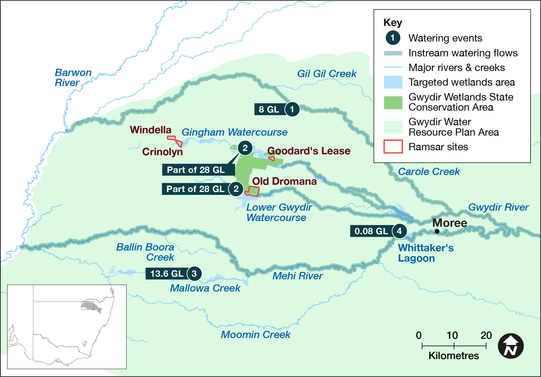
This table and chart provide a summary of 50,229 megalitres of water for the environment delivered in the Gwydir catchment during the 2021–22 watering year. Figures are accurate at the date of publishing, but maybe adjusted. Watering event numbers in the table and bar chart relate to location numbers marked on the map.
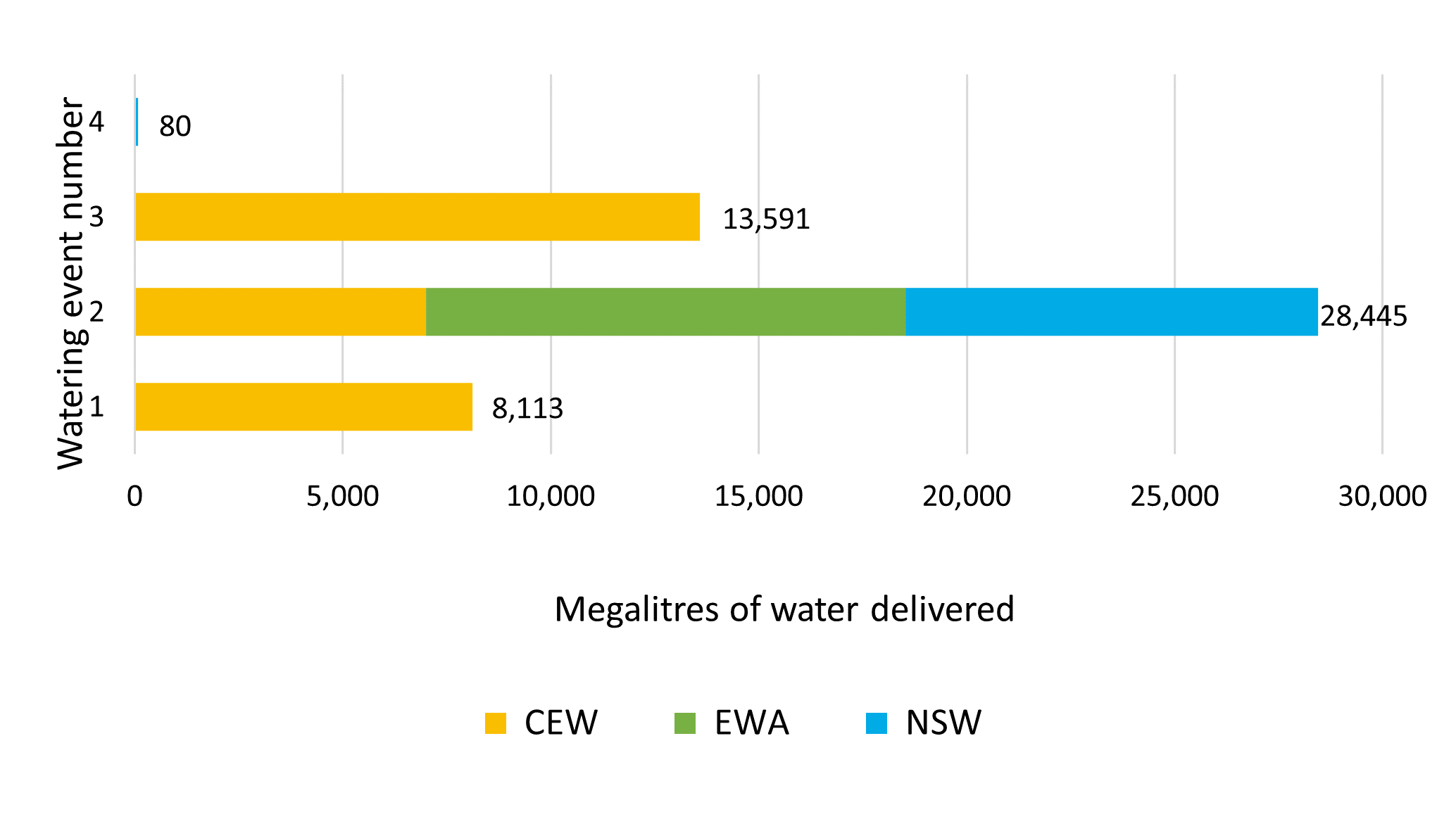
Notes: NSW = NSW licensed environmental water; CEW = Commonwealth licensed environmental water; EWA = environmental water allowance accrued under the water sharing plan; NSW = NSW licensed environmental water.
| Watering event number | Location | Outcomes | Start date | Finish date |
|---|---|---|---|---|
| 1 | Restoring natural flows | Native fish Connectivity | 19 Jul 2021 | 19 Jul 2021 |
| 2 | Restoring natural flows | Native fish Connectivity | 3 Jun 2022 | 22 Jul 2022 |
| 3 | Colonial waterbird breeding | Waterbirds Vegetation | 20 Dec 2021 | 17 Apr 2022 |
| 4 | Mallowa Creek watercourse | Waterbirds Vegetation | 24 Dec 2021 | 17 Apr 2022 |
| 5 | Whittakers Lagoon | Waterbirds Vegetation | 28 Jan 2022 | 30 Jan 2022 |
Outcomes
In 2021–22 environmental water managers worked with stakeholders and the community to deliver flows to target areas across the catchment to support waterbird breeding, native fish, vegetation and connectivity.
Water from all environmental sources was accessed this year including NSW and Commonwealth Environmental Water Holder (CEWH) allocations. The first managed delivery was in July 2021, when CEWH supplementary water was activated to keep more water in Carole Creek to increase connectivity to instream anabranches and downstream to the Barwon River. This event was repeated in June 2022, this time using CEWH high security water from Copeton Dam.
Over spring and summer general security CEWH water was delivered into Mallowa Creek to support waterbirds and wetland vegetation communities. During this event we monitored frogs and, in collaboration with the CEWH monitoring, evaluation and research program (Flow-MER), vegetation and waterbirds. Monitoring revealed these plant and animal communities responded positively to this delivery, although their post-drought recovery was not as high as that observed in similar communities in the Gingham and Lower Gwydir wetlands.
In early 2022 in collaboration with a local irrigator, NSW general security water was delivered to Whittaker’s Lagoon, which is only connected to watercourses during large floodplain flooding. This delivery supported a range of waterbird species including dusky moorhen and white-necked heron nesting. Several semi-permanent vegetation species and frogs completed their life cycles with the delivery of this water.
Following natural flows and triggers, a large-scale breeding event involving an estimated 45,000 pairs of colonial-nesting waterbirds occurred over summer in the Gingham and Lower Gwydir watercourses. After flows receded, approximately 28.4 gigalitres (GL) of NSW and CEWH held and planned water was delivered from Copeton Dam to support the event. This was in addition to 28.6 GL of other flows, including further planned water. Colonies were monitored in collaboration with Flow-MER and flow rates adjusted as needed. Delivered water supported vegetation during the breeding event.
Advice was sought from the Gwydir Environmental Water Advisory Group following significant flows in the catchment. Over autumn and winter planned environmental water that would usually be directed towards Gingham and Lower Gwydir was directed towards the Barwon River via Mehi River and Carole Creek. This action was considered appropriate because of the significant inflows and waterbird breeding was mostly completed by this time.
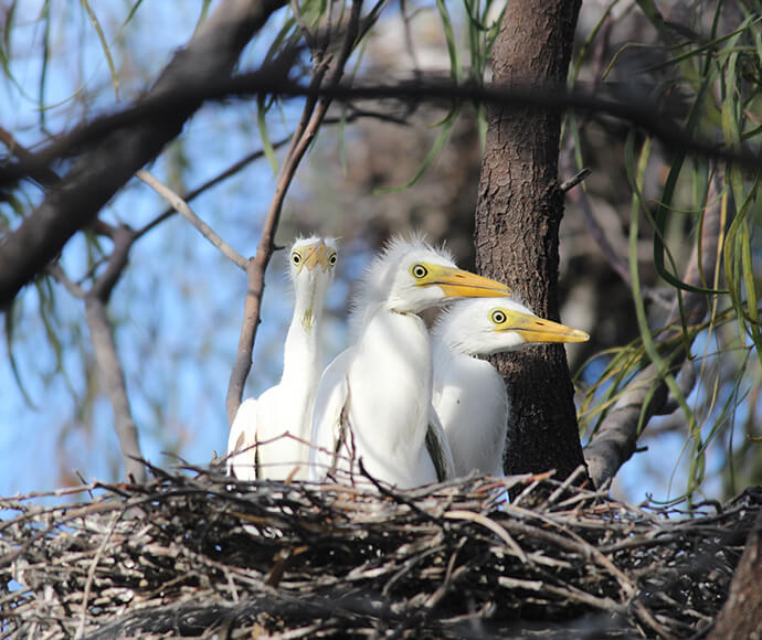
Case study: Largest waterbird breeding event in 10 years
Thousands of waterbirds visited the Gingham and Lower Gwydir wetlands to breed over summer 2021–22. Triggered by large natural flows entering the wetlands, this was the largest breeding event recorded for colonial nesting birds since 2011–12.
Following receding flow rates, environmental water managers worked to deliver sufficient flow rates in combination with natural flows to maintain stable inundation under and around colonies and to support foraging habitats. Flows began in late December 2021 and continued through to late March 2022, where planned environmental water met inundation needs. Flow rates were varied several times in response to changing conditions and environmental needs.
We monitored colonies in a collaborative effort with the Commonwealth Environmental Water Holder, Flow-MER program providers (University of New England and private consultancy), University of NSW, Local Land Services and private landholders. Monitoring included nest and species counts, and colony health and water monitoring. In total, 9 large colonies and 7 small colonies were identified, with 45,000 nests from 14 species supported through to independent juveniles.
Natural flows, rainfall and delivered environmental water resulted in varying inundated areas throughout the duration of the event. This ranged from about 16,000 to 25,000 hectares in the Gingham watercourse and 10,000 to 17,000 hectares in the Lower Gwydir.
Although this flow was for colonially nesting waterbirds, other aquatic flora and fauna, as well as non-aquatic species benefited. This large-scale inundation will have direct benefits to the local area through increased soil moisture and local ground water recharge. The Gwydir made a significant contribution to waterbird colonies in the Murray–Darling Basin in 2021–22. With a wet scenario forecast for 2022–23 it is possible another natural breeding event could be triggered, which would be supported by the program to continue to support waterbird population recovery.