Natural rainfall and dam spills achieved a range of ecological outcomes in the Namoi system in 2021–22.
Key outcomes
Under wet to very wet conditions, rainfall, tributary inflows and stored water met environmental demands in the Namoi system in 2021–22. Environmental water managers adopted a ‘watching brief’ to identify whether intervention with environmental flows would be required. The objective of flow management was to:
- inundate floodplain and anabranch wetlands downstream of Keepit Dam to Walgett
- allow unrestricted fish passage along the Namoi and Peel Rivers
- support recruitment of golden perch and other flow specialist native fish
- provide connectivity between the Peel, Namoi, and Barwon rivers.
Catchment conditions
During 2021–22 the Peel–Namoi catchment experienced various climate conditions with a developing La Niña event. This resulted in wet conditions and generally cool temperatures. Keepit and Chaffey dams filled in late July and August, respectively. Both storages spilled water throughout the year and maintained 100% storage capacity. General security allocations reached 105.3% in the Lower Namoi, and 100% in the Peel, as well as 100% allocation in the Chaffey Environmental Contingency Allowance.
These changing circumstances heavily influenced the watering approach and outcomes sought. Environmental water managers adapted their watering plans in response to catchment conditions and changing environmental needs.
About the catchment
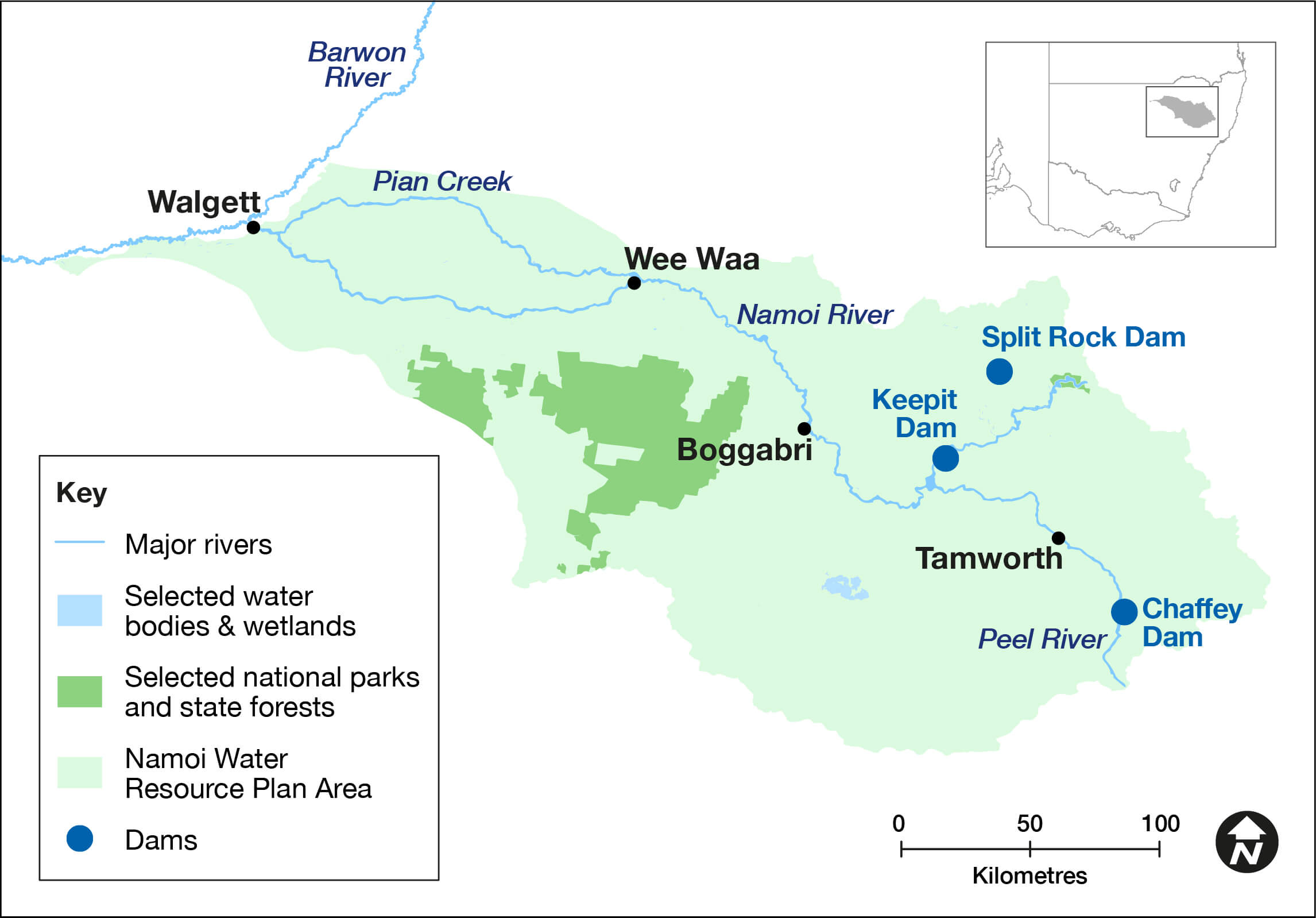
The Namoi catchment is in northern New South Wales and covers an area of 42,000 square kilometres. Located in a temperate climate zone, rainfall typically occurs in summer. The major regulated rivers are the Namoi and Peel, with major water storages at Keepit, Split Rock and Chaffey dams. The Namoi River flows into the Barwon at Walgett.
The lower Namoi catchment is a highly modified landscape, though remnant wetlands are present along the floodplain anabranches downstream of Narrabri, known locally as warrambools. These provide important habitat for waterbirds and nursery areas for native fish.
The Namoi and Peel rivers support native fish including Murray cod, silver perch and freshwater catfish. The Namoi River between Gunnedah and Narrabri provides important habitat for critically endangered silver perch. Lake Goran, in the unregulated Mooki catchment, is listed as a wetland of national significance, and provides habitat for waterbirds when inundated.
The Namoi River is the second largest contributor of flow into the Barwon River, providing an important source of water and opportunities for the movement and survival of native fish.
Traditional owners
The Namoi is Country to the Gomeroi/Kamilaroi First Nation.
Watering aims
Under a moderate to wet resource availability scenario, environmental water managers and their delivery partners identified water use objectives in the Namoi catchment – Water for the Environment: Annual Priorities 2021–22, which were to:
- continue drought recovery of native fish populations in the Peel and Lower Namoi Rivers
- provide a low flow connection with the Lower Namoi and Barwon River
- provide a ‘small fresh’ in the Peel River during spring to promote instream productivity and fish movement opportunities.
With favourable catchment conditions and significant inflows persisting throughout the year, environmental water managers adopted a ‘watching brief’ to identify whether intervention with environmental water would be required to support assets or objectives.
Water delivery
Persistent tributary inflows, combined with spills from Keepit and Chaffey dams, met environmental water demands in the Peel and Lower Namoi rivers during 2021–22.
The natural rainfall inflows, coupled with warm surface water release over the storage spillways, delivered ideal support to riverine and floodplain assets throughout the year. Subsequently, environmental water managers and their delivery partners decided not to use any available allocations and held over unused volumes in the Lower Namoi to the 2022–23 water year.
Outcomes
In 2021–22 environmental water managers planned to adaptively manage available water for the environment to support drought recovery in the Namoi and Peel rivers. However, natural flows met environmental demands and water for the environment was not required. Natural floods provided significant environmental benefits as they inundated water-dependent assets well beyond the capacity of state and Commonwealth environmental water holdings.
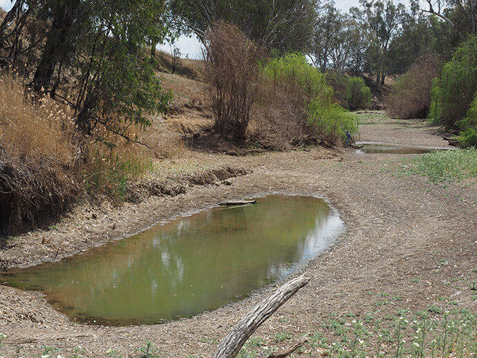
A full 365 days of flow connectivity was observed between the Lower Namoi and Barwon rivers. This continuous flow provided an excellent opportunity for the dispersal and movement of native fish between the 2 river systems, including juvenile golden perch (yellow-belly) which had bred in the Barwon River. Flow conditions in the lower Namoi River between spring and mid-summer promoted breeding of golden and silver perch, although no formal monitoring was undertaken to confirm if breeding occurred in the Namoi.
The warrambools and river red gum/coolabah communities located on the higher floodplains downstream of Narrabri received prolonged periods of inundation over summer. For some parts of the floodplain, this was their first inundation in more than 10 years. This flooding will promote regeneration and support drought recovery within these remnant vegetation communities.
In the Peel River, water spilled from Chaffey Dam and removed the accumulated sediment below the storage from the low flow river channel. This sediment removal, coupled with the mobilisation of organic matter from instream bars, helped improve the health and productivity within this section of the river. Improved productivity means more food for native fish, platypus, water rats and other water-dependent wildlife.
Also noteworthy was the filling of Lake Goran, the largest natural open waterbody in the Namoi. This lake provides unique habitat for migratory shorebirds.
Case study: The time value of water
The challenge for environmental water managers is to identify the best time to use water for the biggest environmental benefit. This is compounded in the Namoi River as the volume of environmental holdings is a small 14 gigalitres (GL). In contrast, the regulated Macquarie River has 334 GL available to support water-dependent assets.
Water for the environment is needed to support the health of rivers, wetlands, waterbirds, and native fish populations throughout the Murray–Darling Basin. During wet years when large-scale flooding occurs, natural flow events provide for the bulk of environmental demands reducing the need for intervention.
After wet years we can expect periods of lower rainfall. In these drier years, water for the environment can be used to support rivers until the next flood arrives.
Water for the environment is used during these periods to prevent permanent loss and irreversible damage to water-dependent plants and animals. For native fish this requires water to support the river pools where they find refuge, so after the drought breaks these fish provide the breeding stock from which their numbers can recover.
In 2021–22, environmental water managers did not use the available Namoi environmental allocation and chose instead to carryover the water into 2022–23. The ability to carryover unused water provides flexibility for water managers to plan and identify the most beneficial time to release the entitlement. Carryover promotes effective use of the limited environmental water entitlement in the Namoi during dry times.
The regulated Peel River does not have carryover. This places our native fish and other water-dependent fauna at a much higher risk during drought as environmental water managers have less, if any, water available to support the environment.