About Toorale National Park and State Conservation Area
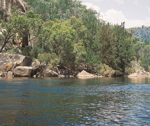
The Toorale National Park and State Conservation Area (Toorale) is located at the junction of the Warrego and Darling Rivers about 65 kilometres south-west of Bourke in north-western New South Wales.
Toorale, a former agricultural property, has outstanding environmental and cultural values. It was bought in 2008 by the NSW Government with substantial support from the Australian Government. At the same time, the Australian Government bought the water access licences held by Toorale.
For more information on the national park, go to the National Parks and Wildlife Service's Toorale National Park webpage.
The Commonwealth Environmental Water Holder now holds and uses these licences to deliver environmental benefits on Toorale and the Darling River.
Water infrastructure at Toorale
Toorale had extensive historic infrastructure initially built to regulate water across the property for agricultural purposes. This included water storage dams along the Warrego River that altered the natural flow patterns.
When the NSW Government bought Toorale, the main in-channel storages (starting from the upstream end of the Warrego River) were Boera Dam, Booka Dam, Homestead Dam and Peebles Dam.
The New South Wales and Australian governments agreed to change water infrastructure to improve water flows for environmental purposes. The Toorale Water Infrastructure Project was completed in 2 phases:
- Phase 1 – Removal of Peebles Dam (completed in October 2019): This first phase of the project removed a section of the Peebles Dam bank across the lowest reach of the Warrego River.
- Phase 2 – Modifications to Boera and Homestead dams (completed in July 2022): Boera Dam was modified to install gated culverts. The gates can be operated to either pass flow downstream in the Warrego River or out to the Western Floodplain, or a combination of both.
The new structure increased the capacity to pass flows down the Warrego from 600 ML/day up to 900 ML/day and under critical circumstances 1,650 ML/day.
Homestead Dam was modified to pass higher flow downstream by a 'fill and spill' arrangement, so Homestead Dam does not require any active operation to pass inflows.
Fishways were constructed at the 2 dams for fish to migrate upstream and downstream along the Warrego River and into the Darling River.
Why is Toorale important to protect?
During planning and construction, the project engaged the Aboriginal community (represented by the Toorale Joint Management Committee), local landholders, downstream water users and representatives from local, state and Australian Government departments.
The area around the junction of the Warrego and Darling rivers is part of Country for the Kurnu-Baakandji Aboriginal people. Toorale has extensive evidence of Aboriginal occupation and activity, including over 500 known Aboriginal sites. Artefacts recorded during 2018 have been dated at over 50,000 years old.
The Kurnu-Baakandji people have a continuing connection and role in the management of the National Park through the Joint Management Committee.
Toorale is also one of the earliest examples of early European water management and engineering, including the construction of Boera Dam and Floodwaters Scheme around 1892.
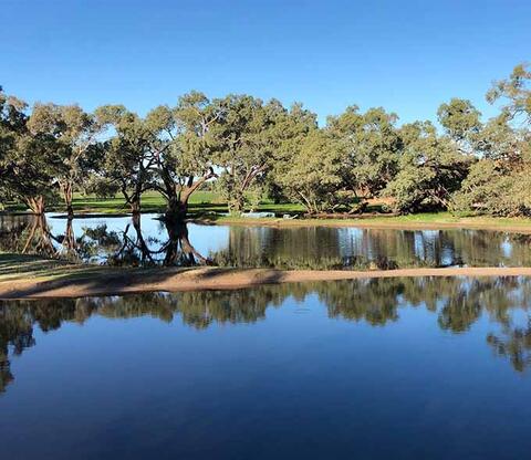
The Warrego and Darling rivers, including the Western Floodplain on Toorale, provide habitat for diverse wildlife and plants, including threatened species.
When inundated, the wetlands along the floodplain spring to life, supporting abundant native fish, frogs and waterbirds, including pelicans and brolgas.
The lush lignum provides one of the few remaining habitats suitable for waterbird breeding in the northern Basin. Around 57 different waterbird species inhabit the wetlands, channels and dams of Toorale.
Studies have also highlighted the importance of the Warrego River for many of our native fish species. For example, the Warrego River is a significant source of golden perch to the Barwon–Darling system.
Extensive ecological monitoring has been undertaken at Toorale and is ongoing under the Flow-MER project delivered by the Commonwealth Department of Climate Change, Energy, the Environment and Water.
Future fish monitoring will improve knowledge and inform decisions about relative environmental demands on Toorale and the Darling River.
The Toorale Water Infrastructure Project
Completing the project ensures that the important environmental and heritage values of Toorale are maintained or enhanced while achieving greater flexibility for flows to the Darling River. The project has:
- increased the maximum flow rate that can be delivered to the Darling River
- retained the capacity to divert flows from Boera Dam to the Western Floodplain
- improved fish passage connectivity between the Warrego and Darling rivers
- minimised impacts on Aboriginal cultural heritage, and supported the recognition and maintenance of Aboriginal cultural values
- considered social and stakeholder values in the development of options, including adjacent and downstream stock and domestic water access
- considered recreational and aesthetic values.
How much water has been returned to the environment?
The Australian Government's purchase of 25,498 megalitres (ML) of Toorale unregulated water entitlements, as transferred to the Commonwealth Environmental Water Holder, comprises:
- 17,826 ML in the Warrego River
- 7,672 ML in the Darling River.
The amount of available water that can be used under each licence varies from year to year according to rainfall, inflows and catchment conditions.
A summary of how the Commonwealth Environmental Water Holder 's Toorale water licences have been used since 2010 can be found at History – Northern Unregulated Rivers (Intersecting Streams and Barwon-Darling).
The Toorale water management infrastructure operating and maintenance plan outlines how to operate and maintain water infrastructure at Toorale. It aims to balance the needs of the park's environment and the downstream river while minimising impacts on other users. The plan ensures compliance with legal requirements and was approved in June 2022. It explains how to manage water flows to prioritise environmental needs and handle risks. It also guides decisions on water management before, during, and after flow events. Additionally, a Fishway Management Plan is being developed to be included after testing the new structure at Boera.
Measuring flows at Toorale
River flows through Toorale can be very unpredictable, ranging from no flow or low flow to high flow. The way the river interacts with the park is complex and changes with each flow event, similar to other river systems in the northern Basin.
The gates on Boera Dam remain closed to maintain the storage level in the dam to provide a refuge pool unless there is an upstream flow event. When Boera Dam gates are operational, the NSW Department of Climate Change, Energy, the Environment and Water reports Warrego River flow management.
Flow management and measurement at Toorale is undertaken via approved methods, consistent with the NSW Non-Urban Water Metering Policy.
When flows get to Toorale/Boera after a cease to flow in the Warrego River, the gates are opened until connectivity with the Darling River is achieved and the flows downstream reach a certain rate, and specific conditions are met. When the Western Floodplain is being watered, flows are still maintained through Boera Dam to enable connectivity with the Darling River, until upstream flows cease.
Flows to the Western Floodplain are generally held environmental water except under high flow conditions when flows entering the Western Floodplain are considered planned environmental water.
For more information, view the Toorale water management infrastructure operating and maintenance plan.
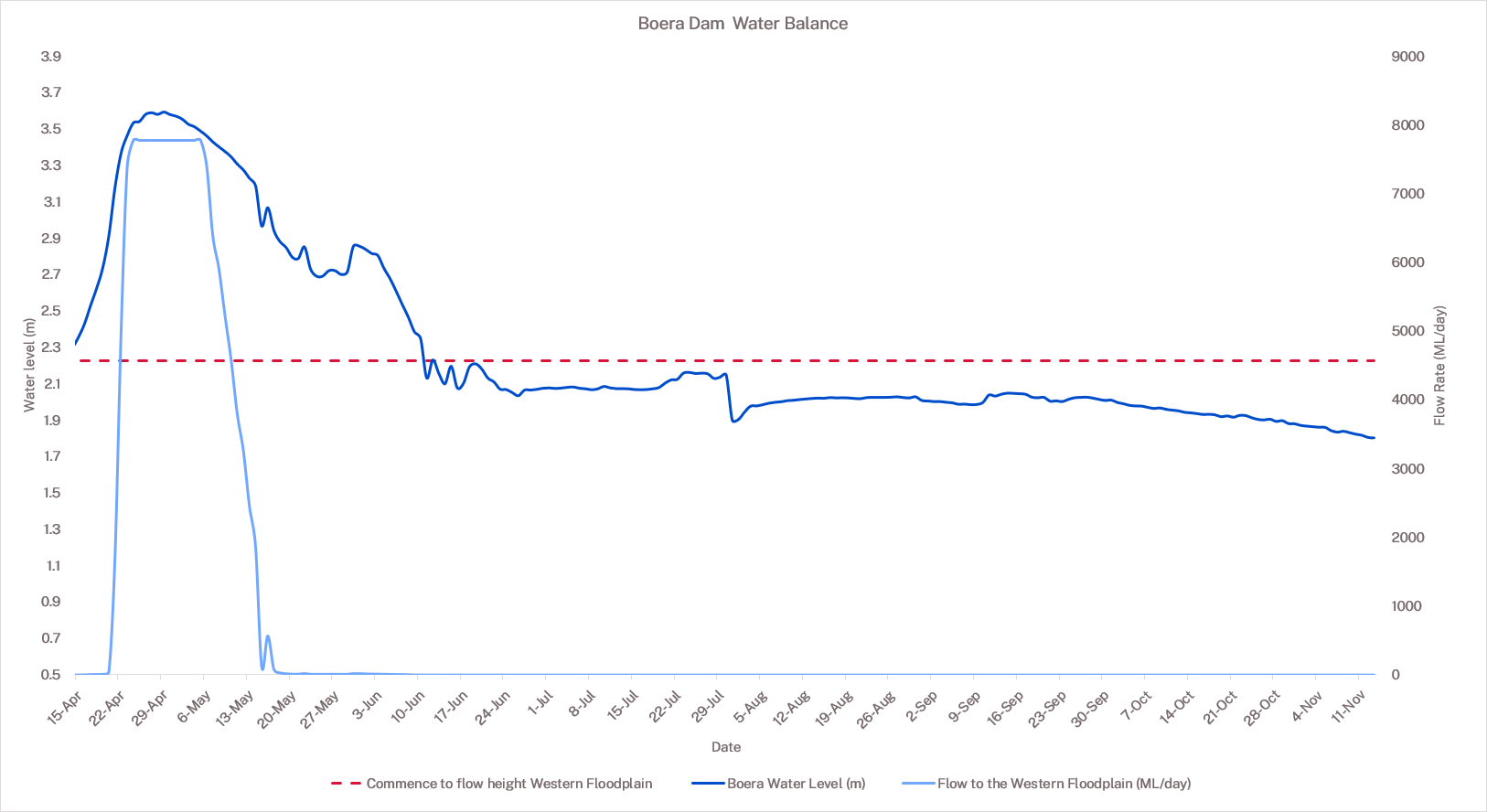
Toorale water infrastructure operations and flows to the Western Floodplain – 11 November 2025
The most recent flow event has officially finished as inflows have dropped to less than 50 megalitres per day (ML/d) at Fords bridge gauges combined for more than 30 days.
Inflows to Boera Dam have largely ceased, though small inflows have been generated from local rainfall in recent weeks. These local run-off events have not been sufficient to exceed the trigger for a new inflow event as specified in the Toorale Water Infrastructure Operations and Maintenance Plan. Inflows are now being passed through Boera down the Warrego, and Boera remains below the Western Floodplain threshold.
Site operations are now subject to new work approval conditions which requires all 6 pipes on the Western Training Wall, which runs along the Western Floodplain, to remain open unless water is being debited from a water access licence or the Boera gates are fully open to pass 1,650 megalitres per day.
The pipes were opened on 7 August 2025, which resulted in much of the residual planned and held environmental water on the northern end of the Western Floodplain from the large event in autumn drain back off the floodplain to the Warrego River.
The department aims to maintain the Boera water level and continue to pass inflows until the next event is triggered by a combined flow of greater than 100ML/d at the Fords Bridge gauges.
| Structure | Status | Date since status changed | Notes |
|---|---|---|---|
| Boera – gate 1 | Closed (set at Western Floodplain entry level) | 16/06/2025 | No flow through this gate |
| Boera – gate 2 | Open (set 25cm below Western Floodplain entry level, just below current storage level) | 19/09/2025 | No flow passing through this gate, though it is set below the commence to fill for the Western Floodplain to pass any unanticipated inflows and avoid watering the Western Floodplain |
| Boera – gate 3 | Closed (set at Western Floodplain entry level) | 07/08/2025 | No flow through this gate |
| Boera fishway | Closed | 18/07/2025 | Inflows have been below the rate required to run the fishway without draining the storage |
| Boera auxiliary channel | Closed | 22/05/2024 | Only operated under higher flows |
| Western Training Wall Pipe 1 | Fully open | 07/08/2025 | Opened as required by works approval |
| Western Training Wall Pipe 2 | Fully open | 07/08/2025 | Opened as required by works approval |
| Western Training Wall Pipe 3 | Fully open | 07/08/2025 | Opened as required by works approval |
| Western Training Wall Pipe 4 | Fully open | 07/08/2025 | Opened as required by works approval |
| Western Training Wall Pipe 5 | Fully open | 07/08/2025 | Opened as required by works approval |
| Western Training Wall Pipe 6 | Fully open | 07/08/2025 | Opened as required by works approval |
| Booka Dam pipes | Closed | 07/08/2025 | Only operated under very high flows. Fish and flows are able to bypass the structure |
| Homestead Dam fishway | Closed | 21/07/2025 | Inflows have been insufficient |
| Homestead Dam pipes | Closed | 09/05/2025 | Only operated under very high flows. Fish and flows are able to bypass the structure |
| Trigger | Status |
|---|---|
| Event start – Fords Bridge gauges exceed 100ML | Not met – no event currently active |
| Louth gauge exceeds 979ML/d | Met |
| Warrego connection to Darling-Baaka | Met |
| Flow registered at Dicks Dam gauge | Not met |
| Event end – Fords Bridge gauges below 50ML for more than 30 days | Met – event finished (31/07/2025) |