Water for the environment is managed to deliver benefits for communities and important environmental assets of the regions in which these communities live. While communities and industries face significant challenges during dry times, our rivers and wetlands also do it tough.
New South Wales is home to a unique array of native plants and animals that rely on our rivers and wetlands to survive the boom and bust cycles that shape the Australian landscape.
Water for the environment is a share of the water available in our dams and rivers that is managed to support the ongoing health of local waterways.
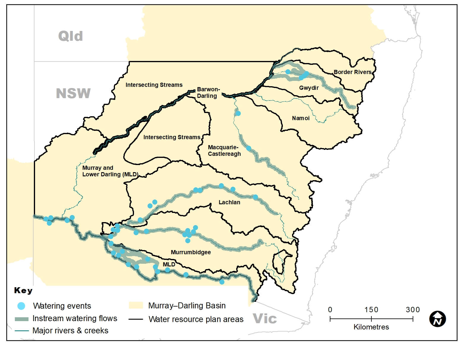
New South Wales catchment areas map
- Murray and Lower Darling – Murray and Lower Darling Water resource plan area, 135,608 megalitres delivered to multiple sites in the Murray and Lower Darling catchments
- Murrumbidgee – Murrumbidgee Water resource plan area, 80,493 megalitres delivered to multiple wetlands an instream flows in the Murrumbidgee catchment
- Lachlan – Lachlan Water resource plan area, 31,934 megalitres delivered to wetlands an instream flows in the Lachlan catchment
- Macquarie–Castlereagh – Macquarie–Castlereagh Water resource plan area, 4583 megalitres delivered to the Macquarie Marshes and Macquarie River
- Gwydir – Gwydir Water resource plan area, 16,026 megalitres delivered to watercourses in wetlands in the Gwydir catchment
- Barwon–Darling – Barwon–Darling Water resource plan area
- Border Rivers – Border Rivers Water resource plan area
- Namoi – Namoi Water resource plan area
- Intersecting Streams – Intersecting Streams Water resource plan area.
The Department of Planning, Industry and Environment – Environment, Energy and Science (DPIE – EES) is responsible for ensuring that water is managed in accordance with relevant statutory plans, including water sharing plans established under the NSW Water Management Act 2000 and the Basin Plan established under the Commonwealth Water Act 2007. Visit our Water for the environment webpages for further information on what we do, how we make decisions and how we deliver environmental flows.
This outcomes report details our work in 9 water resource plan areas within NSW to support river systems and meet the needs of native plants, native fish, waterbirds and other water-dependent wildlife so they can be enjoyed by all, now and into the future.
Executive summary
Maintaining and restoring the health of rivers and wetlands for future generations is the aim of our water for the environment program. During dry times, our adaptive management approach allows us to focus our efforts on outcomes that can be achieved with reduced access to water.
In 2019–20, the DPIE – EES Water for the Environment Team managed the delivery of approximately 268,643 megalitres of water across 40 delivery events for the environment. This water for the environment was sourced from NSW Commonwealth, The Living Murray and River Murray Increased Flows accounts and delivered to key sites across the state.
Planning for the year was based on a dry to very dry resource availability scenario.
Where water was available, teams focused on providing a mosaic of drought refuge sites to support key populations of native fish, waterbirds, plants and other water-dependent wildlife. In more severely drought-affected catchments, teams worked with other water agencies to influence available in-stream flows for stock or domestic uses to provide dual environmental benefits.
Although very dry conditions continued through to early 2020, some key planned actions were implemented. Rainfall increased across all 9 catchments from February 2020 enabling environmental gains through natural and/or managed flow events.
In catchments particularly affected by dry conditions, we targeted refuge sites where native fish, waterbirds and other wildlife had congregated in and around the remaining pockets of water.
We worked with community advisory groups to prioritise the sites to receive water and build on the successes of previous years. Where possible, we also managed our water reserves to hold some water in account for future dry times.
We also collaborated with numerous landholders across the rivers and floodplains in which we work. Their support and cooperation is critical to the successful outcomes achieved.
We manage water on behalf of the NSW Government and partner with the Commonwealth Environmental Water Holder (CEWH) and The Living Murray program.
Water was used strategically to:
- support habitat health
- provide essential refuge sites as the drought continued
- make subtle but important changes to river flow patterns at a number of locations to provide triggers for native fish to breed
- connect rivers with key floodplain wetlands and give native fish increased access to habitat and food.
Connectivity
Work on the Water Infrastructure Project at Toorale National Park and State Conservation Area (Toorale) continued in 2019–20. This involved removing, modifying or decommissioning existing water infrastructure on Toorale to support environmental outcomes. In October 2019, Peebles Dam was removed from the Warrego River, improving connectivity between the Darling and Warrego Rivers and floodplains.
The aim of the project is to enable greater water flow capacity through the lower reaches of the Warrego River and into the Darling River for downstream environmental benefits and improved fish passage. Flows in the Warrego system in spring 2019 and autumn 2020 extended through Toorale with the use of the Commonwealth held environmental water entitlement directed into the Darling River and onto the western floodplain
Native fish
Whole of system flows in the Murray catchment provided an important opportunity for native fish to feed, breed and move throughout the river system. This ensures populations of native fish are able to recover and repopulate when more favourable conditions return to the landscape.
Water for the environment was delivered into Tuppal Creek, between Tocumwal and Deniliquin. DPIE – EES is developing a works program with Murray Irrigation and Tuppal Creek landholders to allow higher flows to move unimpeded along the creek. This will improve passage for large-bodied native fish species such as Murray cod.
Waterbirds
During spring 2019, a whole-of-system multi-site flow in the Lachlan River provided critical foraging and roosting habitats for a diversity of waterbirds at multiple sites in the mid- and lower-Lachlan. These included threatened species such as the freckled duck, blue-billed duck and brolga, as well as migratory shorebirds such as Latham’s snipe, common greenshank, sharp-tailed sandpiper and resident wader species.
Native vegetation
In early 2020, a total of 3.4 gigalitres of water was delivered to the wetlands of the Lower Gwydir and Gingham watercourses. This watering took advantage of natural river flows due to rains returning to the catchment and inundating 3500 hectares in the Gingham and Big Leather (Lower Gwydir) watercourse wetlands. Surveys indicated good growth of flow-dependent vegetation, provision of habitat for many waterbird species and strong recruitment of frog species.
The arrival of widespread rain toward the end of the water year means water managers can now focus their attention on recovery and restoration of the rivers, wetlands, native vegetation and animals hard-hit by drought. In consultation with local community advisory groups, we have started implementing adaptive management plans to support the health of our rivers, wetlands and wildlife.
Where water for the environment has been available, we have achieved a range of important outcomes for rivers and wetlands along with the wildlife that rely on them. The flows that support one species invariably support many other beneficial outcomes. Here are a few highlights from the 9 water resource plan areas across the state.
Murray and Lower Darling catchments
In 2019–20 we delivered 135.6 gigalitres of water to rivers, creeks and wetlands on private and public land. For example:
- we worked with state and federal partner agencies to connect rivers and floodplain wetlands on a landscape scale
- managed flows triggered breeding and movement of native fish
- water for the environment boosted floodplain productivity and the aquatic food web
- our work supported habitat health and plant growth
- we partnered with a private irrigation company to upgrade and install new infrastructure that increased flows and improved outcomes for the Tuppal and Thule creeks
- we delivered water to several private wetlands using irrigation infrastructure and private pumping to support southern bell frog populations in the central Murray
- we managed the delivery of water for the environment into the Bottle Bend Reserve to support black box and lignum.
Murrumbidgee catchment
In 2019–20 we delivered 80.5 gigalitres of water to rivers, creeks and wetlands on private and public land. This water delivery:
- connected the river with floodplain wetlands to core water sites and provide habitat for threatened species including Australian bitterns and southern bell frogs
- used existing infrastructure to provide water to wetlands on the Lowbidgee floodplain
- triggered breeding and movement of native fish
- boosted floodplain productivity and the aquatic food web
- replenished wetland refuges in anticipation of possible dry times ahead
- provided critical refuge habitat for native fish, turtles and frogs at sites throughout the catchment
- allowed us to manage higher flows to meet the needs of native fish in anticipation of heat wave conditions.
We also worked with a private irrigation company to deliver water to private property wetlands to support southern bell frogs, waterbirds and native plant life.
Lachlan catchment
In 2019–20 we delivered 31.9 gigalitres of water to rivers, creeks and wetlands on private and public land. For example, we:
- worked with the CEWH to provide a variety of refuge habitats for wildlife under stress from the drought
- provided critical foraging habitat for the Lachlan’s last-known population of olive perchlet
- partnered with the mid-Lachlan Aboriginal community and Ngiyampaa Nation to support and access cultural values and practices associated with Booberoi Creek
- supported a range of native wildlife and plant communities in anabranch (a stream branching off from a river or creek and rejoining it further downstream) systems and creeks.
Macquarie–Castlereagh catchment
In 2019–20, water for the environment was quarantined in a drought account. However, a NSW and CEWH delivery of 4.6 gigalitres was made to supplement natural flows later in the water year. This meant we:
- were unable to complete the third year of the 3-year watering strategy for the Macquarie Marshes
- worked with partner agencies to incorporate critical environmental needs into river operations
- relocated freshwater turtles from drying pools to long-lasting weir-pool habitat
- made use of supplementary held environmental water to maximise flows to the Macquarie Marshes after rainfall rebooted the river system.
Gwydir catchment
In 2019–20 we delivered 16 gigalitres of CEWH water to rivers, creeks and wetlands in this catchment. This enabled us to:
- maintain water quality and water levels in refuge pools along the Carole Creek, Mehi and main Gwydir river channels
- deliver water to Whittaker’s Lagoon on the Mehi floodplain to support native fish survival and attract birdlife
- support vegetation growth and recovery in the Lower Gwydir watercourse wetlands to provide habitat for waterbird species and encourage recruitment of frogs.
Barwon–Darling catchment
In 2019–20, no deliveries of water for the environment were made. During this water year we:
- worked with partner agencies to protect first flush flows at the start of the year
- partnered with Department of Primary Industries – Fisheries to monitor water quality as part of the first flush at Brewarrina
- observed rainfall and natural flows that allowed a number of environmental water requirements to be met that connected habitats, triggered fish movement and inundated instream benches (sediments banks within the river channel) for improved productivity.
Border Rivers catchment
In 2019–20, no deliveries of water for the environment were made. During this water year we:
- worked with partner agencies on drought response actions for the aquatic ecosystems of the Border Rivers
- advised on the release of flows for town water supplies to achieve dual environmental benefits
- observed rainfall and resulting flows that provided small fresh events in the Severn River, downstream of Frazers Creek
- observed rainfall and natural flows that provided small and large freshes in the Dumaresq River
- observed rainfall and natural flows that included a continual base flow in the lower section of the Macintyre River.
Intersecting Streams catchment
In 2019–20 we operated dam structures in Toorale National Park and State Conservation Area to provide water from the Warrego River to connect to the Darling River and the Warrego River floodplain.
Namoi catchment
In 2019–20, no deliveries of water for the environment were made. During this water year we:
- provided advice to partner agencies on critical environmental needs within the NSW drought management response framework
- observed rainfall and natural flows that replenished water levels, refreshed water quality, boosted productivity and allowed large-scale fish movement
- managed the release of an environmental water allowance made available when the use of a pipeline from Chaffey Dam to Dungowan caused cease-to-flow conditions below a temporary weir on the Peel River
- observed rain and natural inflows that replenished river pools upstream of the Cockburn and Peel river confluence in combination with the environmental water allowance.
Monitoring, evaluation and reporting update
Through our Monitoring, Evaluating and Reporting (MER) Program we monitor indicators of river and wetland health within the framework of 4 major themes:
- river flows and connectivity
- native vegetation
- native animals, including waterbirds and frogs
- native fish.
In addition to monitoring specific environmental water events, we conduct systematic ground surveys of waterbirds, frogs and vegetation in key wetland habitats each year to measure their responses to flows and flooding regimes. Throughout the year we use satellite imagery to track the extent of inundation in floodplain wetlands targeted by water for the environment (for example, Gwydir wetlands, Macquarie Marshes, Lower Lachlan wetlands, Lowbidgee floodplain and Millewa forests). We work with independent researchers, tertiary institutions and community groups to gather data which is used to inform progress toward long-term water plan objectives and Basin Plan obligations.
In New South Wales, state and Commonwealth agencies work together to deliver water for the environment with the overall goal to generate ecological benefits for rivers, wetlands and their dependent plants and animals. Under the Murray–Darling Basin Plan (the Basin Plan) this goal is known as ‘Matter 8: the achievement of environmental outcomes at an asset scale’. The Basin Plan requires member states to report on their progress in achieving environmental outcomes in their jurisdiction every 5 years.
The first ‘Matter 8’ report was prepared by the NSW Government in 2020 and covers the 5-year period between 1 July 2014 and 30 June 2019. The report was prepared by the 3 key NSW agencies involved in environmental water management and monitoring:
- Department of Planning, Industry and Environment (DPIE) – Energy, Environment and Science
- DPIE – Water
- Department of Primary Industries – Fisheries.
The NSW report is complete and has been presented to the Murray–Daring Basin Authority.
The year in review
Drought and low water availability saw a reduction in the number and area of wetlands watered in 2019–20.
Where water was available, it was provided to a range of different wetland habitats including non-woody wetland vegetation, river red gum forests and woodlands, and lignum shrublands at different times of the year.
Inundation extent was variably distributed across the large Gwydir wetlands, Macquarie Marshes, Lowbidgee floodplain and Millewa forest.
There were good inundation outcomes across these wetlands during 2019–20. This included inundation of about:
- 60% of non-woody wetland vegetation (ranging from 52% to 76% of non-woody wetland inundated depending on the wetland)
- 15% of river red gum forests
- 14% of woodland communities (river red gum, coolibah, black box)
- a small (7%) overall proportion of lignum shrubland, but this varied widely (4–32%) depending on the wetland and where water for the environment was targeted – these inundation extents were small, but provided critical refuge habitat within an otherwise dry landscape.
Waterbird surveys
Waterbirds were surveyed from the ground in spring 2019 in various locations of the Gwydir, Macquarie, Lachlan, Murrumbidgee and Murray regions.
There was a diversity of species across all monitored inundated wetland survey sites, including threatened species and migratory species recognised by international treaties.
Waterbird abundance and the diversity of species increased after being inundated by water for the environment in some locations, including parts of the lower Lachlan, mid-Murrumbidgee and Lowbidgee floodplain.
Often this was the only inundated habitat in the landscape. Targeted refuge watering for waterbirds and other wetland-dependent animals in the Lowbidgee and lower Lachlan supported the NSW-listed threatened freckled duck and blue-billed duck.
During the spring waterbird surveys there were limited environmental flows for some wetland sites (for example, no water for the environment was delivered to the Macquarie Marshes, and flows were limited to one wetland in the Gwydir (Whittaker’s Lagoon).
Waterbird breeding activity was limited to a small number of species in a few locations in the 2019–20 water year given the very dry conditions over spring and summer.
Frog surveys
In the northern Murray–Darling Basin (the Basin), extended drought conditions and limited environmental water delivery meant that no or very little water remained in the wetlands during the spring frog surveys in the Macquarie Marshes and Gwydir, except for Whittaker’s Lagoon in the Mehi River system.
Five frog species were observed in the Macquarie Mashes and 8 species were observed in the Gwydir. Apart from sites that contained some water (for example, Whittaker’s Lagoon), very few frogs were seen and breeding activity was absent.
In the southern Basin where water availability was higher, environmental flow events in the Murrumbidgee and the Murray supported frog habitat, including objectives specific to the endangered southern bell frog.
In the Murrumbidgee, DPIE – EES’s Saving Our Species program detected southern bell frogs in almost 25% of surveyed sites. The Commonwealth Environment Water Office-funded Murrumbidgee Flow-MER program detected southern bell frogs in 50% of sites, including some breeding activity as a result of environmental flows.
In the Murray, DPIE – EES’s Saving our Species program detected southern bell frogs at about 65% of surveyed sites, although breeding activity was limited to one site.
Water holdings
The Department of Planning, Industry and Environment – Environment, Energy and Science (DPIE – EES) is the lead agency for the delivery of water for the environment in New South Wales. This includes collaboration on the delivery of Commonwealth water held by the Commonwealth Environment Water Holder.
This figure summarises current water holdings, or state 'held' water for the environment, recovered to 30 June 2020 (megalitres).
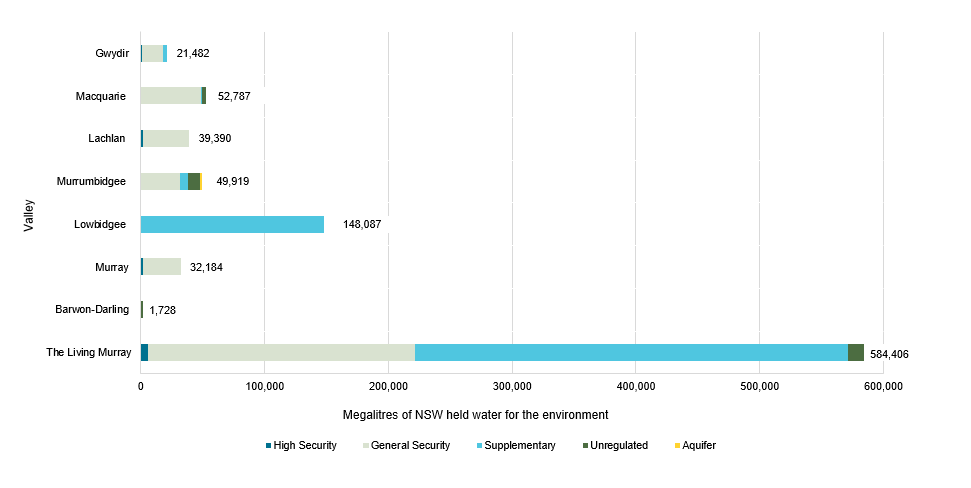
Chart showing New South Wales held water for the environment for each valley.
Water trade
Our business model allows for the periodic trading of water to cover some of the charges involved in holding and managing water licences.
Funds may also be used to purchase water or implement small-scale projects that improve the outcomes of watering events.
In 2019–20, DPIE – EES sold 1,500 megalitres of groundwater allocation and 9,373 megalitres of carryover space in the Murrumbidgee catchment.
Future trade will continue to manage the portfolio for maximum environmental benefit.
More information about understanding water trade is available.
Partners
We work with a range of partner agencies, organisations and individuals to achieve/secure effective and efficient delivery of water to our rivers and wetlands.
These include:
- Commonwealth Environmental Water Office
- Murray–Darling Basin Authority
- Southern Connected Basin Environmental Water Committee
- Environmental Water Advisory Groups
- Department of Planning, Industry and Environment – Water
- Department of Primary Industries – Fisheries
- Murray Lower Darling Rivers Indigenous Nations
- Northern Basin Aboriginal Nations
- recreational fishers
- landholders
- universities.
More information about some of our partner agencies is available on our terms and definitions webpage.