The Intersecting Streams include the Narran, Bokhara, Culgoa, Warrego and Paroo rivers located in far northern New South Wales. The rivers are located on a series of semi-arid floodplains and are fed by rainfall in the central and western areas of Queensland.
The flow in these river systems is intermittent and unregulated, and flow events are typically associated with the southern summer monsoon.
The 2018–19 water year was hot and dry with low rainfall. Some catchment areas received 60–80% of average rainfall, whereas areas close to the border received only 20–60% of average rainfall. Some areas had record-low rainfalls for the 12-month period. The exceptions to this were the Warrego and Culgoa catchments, which received above-average rainfall in April that provided a flow through the Warrego system into the Darling River.
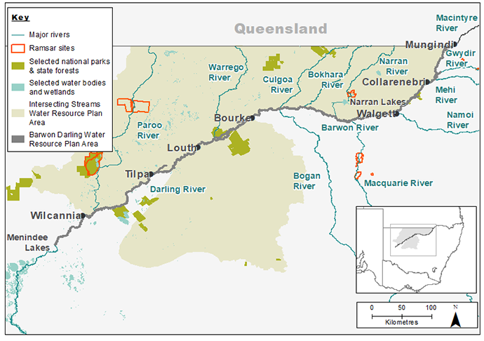
Map of the Barwon-Darling and Intersecting Streams catchments showing waterways, wetlands and locations of water for the environment deliveries made in 2018–19.
Watering aims
Unlike regulated catchments, the management of water for the environment in the Intersecting Streams catchment is largely reliant on improving outcomes from unregulated or natural flows of the rivers. Flows in the river are balanced to meet the needs of instream ecosystems and support floodplains and wetlands.
In 2018–19 the Commonwealth Environmental Water Holder identified priority actions to guide the management of their portfolio of water licenses for this system, subject to river flows.
In the Narran system licensed water entitlements aim to:
- enhance flows to achieve a 25–50 gigalitre event at Narran Lakes
- enhance flows through the Narran and Birrie rivers
- support colonial waterbird breeding at Narran Lakes, if triggered.
In the Warrego system licensed water entitlements aim to:
- enhance flows in the Darling River
- improve habitat and support waterbird breeding at Toorale, if triggered.
Dam structures are operated to balance water needs between the flood plain and Darling River based on conditions at the time.
Outcomes
There was no inflow into the Narran Lakes system in 2018–19. The last inflow to the lakes was in 2016. Lignum shrublands in this system have benefited from limited local rainfall, but are generally declining in condition due to the absence of river inflows.
About 29 gigalitres of water entered Toorale as a result of heavy rainfall in upstream catchments and more than 80% passed through to the Darling River (measured downstream of Louth). This water travelled along the unregulated Darling River to Lake Wetherill downstream of Wilcannia and the top end of the Menindee Lakes system. The flow:
- filled and reconnected pools
- improved water quality
- improved habitat for native fish, which had retreated to refuge pools while the river was under cease-to-flow conditions.
The Warrego flows which reached the western floodplain on Toorale, improved habitat and benefited lignum shrublands, which were a basin priority in 2018–19.
Case study
Following ex-tropical cyclone Trevor in early 2019, a flow event occurred in the Warrego River between April and July.
The event was managed collaboratively by the NSW National Parks and Wildlife Service, the Department of Industry, Planning and Environment, and the Commonwealth Environmental Water Holder.
The event brought much-needed rain to communities along the Warrego and Darling rivers.
Infrastructure on Toorale was managed to maximise flows to the Darling River.
Although flows did not extend as far down the Darling River as hoped, the event helped to replenish waterholes within the mid to lower reaches (Lake Wetherill) of the Darling system.
In combination with local rainfall, these flows:
- provided great benefit in wetting the system
- filled up pools
- connected reaches of the Darling River
- improved water quality
- supported fish, with a recruitment event in the Warrego River
- provided for an increase of birdlife on the western floodplain.
Toorale Water Infrastructure Project
The flow event provided an opportunity to further consult with the community on the Toorale Water Infrastructure Project, which aims to increase the rate at which water can pass through Toorale to the Darling River.
On-site meetings and information sessions held since May 2019 have resulted in adjustments to the project proposal. These adjustments are in addition to matters addressed during the planning and design stages of the project.
The project design will:
- avoid damage to significant Aboriginal cultural heritage and protect sites of cultural value
- include fishways at two locations in response to a request by the Aboriginal community
- allow for delivery and storage of cultural water the Aboriginal community wants to access and use in the future
- meet technical requirements needed to obtain approval.
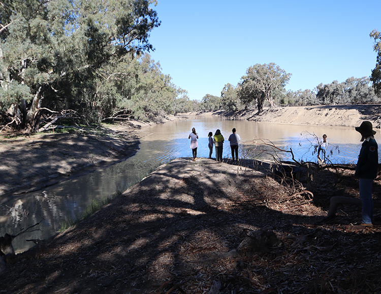
Junction of the Warrego (left) and Darling (right) rivers