The 2018–19 water year began with 232 gigalitres of water for the environment in accounts. However, the ongoing impact of drought in the Macquarie–Castlereagh catchment resulted in early signs of restricted access for all general security water users. Record low inflows to Burrendong Dam resulted in only 70% of the water account volume being made available for use during the year. The remaining 30% is held in a drought account.
2018–19 was the second year of a 3-year release strategy that aims to:
- build resilience into the semi-permanent, mixed marsh and river red gum woodlands of the Macquarie Marshes
- prepare the Macquarie Marshes and native fish populations to respond when the drought breaks
- facilitate connectivity between the Macquarie and Barwon rivers.
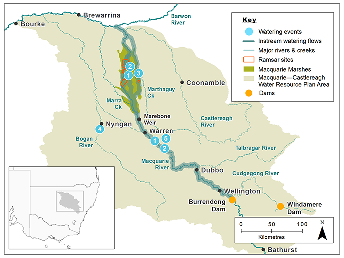
Map of the Macquarie catchment showing waterways, wetlands and locations of water for the environment deliveries made in 2018–19.
Watering aims
Within the context of the 3-year watering strategy, the community-based Macquarie–Castlereagh Environmental Water Advisory Group recommended available water be used to:
- build the resilience of the Macquarie Marshes
- respond to emerging needs of native fish as the drought continued to impact on key habitat areas.
The strategy included carrying forward 60 gigalitres of NSW, Commonwealth and Environmental Water Allocation to 2019–20 to mitigate the impacts of potential future drought conditions. With account limits imposed, 110 gigalitres remain in the drought account, but this water will not be available for use until the drought breaks.
Water delivery
This table provides a summary of water for the environment use in the Macquarie-Castlereagh catchment during the 2018–19 watering year. Volumes are indicative only.
Notes: Location numbers in the table relate to watering events marked on the map.
NSW = NSW licensed environmental water (general security and supplementary licences); CEW = Commonwealth licensed environmental water; EWA = Environmental water allowance accrued under the Water Sharing Plan for the Macquarie and Cudgegong Regulated Rivers Water Source 2016.
| Watering event number | Location | Start date | Finish date | NSW | CEW | EWA | Total |
|---|---|---|---|---|---|---|---|
| 1 | Winter priming flow Macquarie Marshes | 24 Jul 2018 | 24 Aug 2018 | 2720 | 6348 | – | 9068 |
| 2 | Spring flow Macquarie Marshes and Barwon–Darling system | 25 Aug 2018 | 11 Dec 2018 | 18,796 | 39,248 | 48,402 | 106,446 |
| 3 | Eastern Marshes flow | 1 Sep 2018 | 16 Oct 2018 | 2488 | 5805 | 2670 | 10,963 |
| 4 | Fish rescue flow Nyngan Weir pool | 26 Feb 2019 | 10 Mar 2019 | 150 | 150 | – | 300 |
| 5 | Ewenmar Creek Methalibar Weir pool | 30 Apr 2019 | 1 Jun 2019 | 280 | 520 | – | 800 |
| Region | Total |
|---|---|
| NSW | 24,434 |
| CEW | 52,071 |
| EWA | 51,072 |
| Total | 127,577 |
Outcomes
Despite climatic and operational challenges, the delivery of water for the environment in 2018–19 largely achieved planned outcomes.
The combined winter priming and spring flows to the south, north and eastern marshes inundated about 15,000 hectares of the targeted 21,000 hectares. The releases were made over 140 days between July and December and aimed to:
- inundate mixed marsh vegetation, including water couch and common reed
- reach inner areas of river red gum woodlands
- enable seed-setting in marsh vegetation.
Subsequent hot, dry conditions and the absence of follow-up rain-fed inflows over summer led to rapid drying of the areas inundated.
The combination of low rainfall in the marshes and less water available from the account (30% restriction) meant the area inundated was reduced.
Low levels of inundation in the eastern marshes were caused by:
- changed in-channel conditions (low water levels) in the Gum Cowal, which affected gauge accuracy and the rate at which water was delivered
- operational issues
- harsh climatic conditions, including record high temperatures and record high evaporation rates, which limited the spread of water and the duration of inundation.
Monitoring in the marshes, which was completed in spring, reported:
- widespread calling activity by flow-responsive frogs, such as the eastern sign-bearing froglet, spotted marsh frog and the barking marsh frog
- frog egg masses and tadpoles in the north and south marsh
- limited frog activity in the eastern marshes, therefore recruitment in this area was likely to be very limited.
Forty waterbird species, including a rare sighting of the nationally endangered Australasian bittern in the reedbeds in the northern nature reserve, migratory Latham’s snipe and a large flock (>40) of the NSW threatened brolga.
As well as delivery to the Macquarie Marshes, a small volume of water was used to support key refuge pools for native fish to allow them to move to better habitat with improved water quality.
This included:
- Nyngan lower town weir pool, which is the only recorded location of threatened olive perchlet in the catchment this year
- Methalibar Weir pool on the Ewenmar Creek, which supports the threatened eel-tailed catfish.
Case study
In a first for the Macquarie catchment, the NSW and Australian governments partnered with the Tenandra Scheme, an off-river private irrigation scheme, to deliver water to support native fish in the Ewenmar Creek near Warren.
The Macquarie–Cudgegong Environmental Water Advisory Group, which includes members from local interest groups, advised on the use of the small volume of water remaining in environmental water accounts to replenish water levels in key fish refuge locations.
Ewenmar Creek supports the eel-tailed catfish. The Murray–Darling Basin population of eel-tailed catfish is listed as endangered, which makes sites like Ewenmar Creek important to sustain this native fish species.
There had been no flows in the Ewenmar Creek since 2016. Water levels had dropped and water quality had declined raising concerns about the survival of native fish in refuge pools.
Water was delivered to the creek via the network of irrigation channels in April 2019 and reconnected 4 isolated pools along a 15-kilometre reach.
This provided a lifeline to the fish by:
- allowing the fish to move between refuge pools
- boosting available habitat and food
- improving water quality
- supporting breeding and population recovery when the drought breaks and flows return.