The Murrumbidgee catchment saw dry conditions and lower than average inflows in 2017–18. This resulted in 38% general security allocations (to March 15, 2018) with about 100 gigalitres of NSW environmental water allowances available for use.
To build on low starting allocations, water was carried over from the 2016–17 water year. Under these conditions, we worked with the Commonwealth Environmental Water Office to deliver a whole-of-system wetland reconnection flow. This event connected hundreds of wetlands along the Murrumbidgee catchment from the mid-Murrumbidgee through to the Murray junction.
Remaining water for the environment was used to maintain refuge habitats for native fish, frogs and turtles as well as the condition of habitat important to listed waterbird species such as Australasian bitterns.
Some significant ecological outcomes achieved included:
- improved condition of wetland vegetation communities in the mid-Murrumbidgee
- improved fish habitat
- opportunities for breeding and movement.
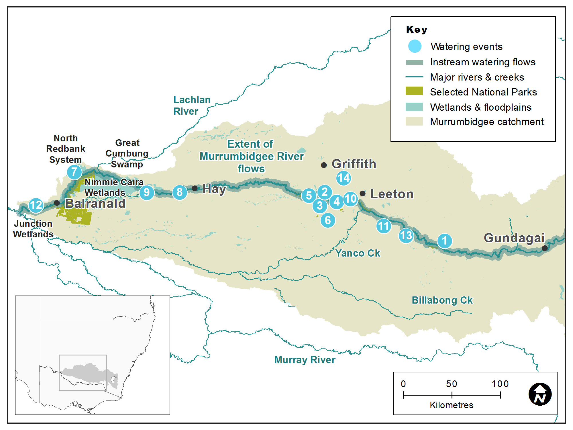
Map of the Murrumbidgee catchment showing waterways, wetlands and locations of water for the environment deliveries made in 2017–18.
Water aims
After a wet year in 2016–17, plans were put in place to use water for the environment to build on the gains of the previous 12 months.
The Murrumbidgee Environmental Water Advisory Group considered the condition of river and wetland assets, water availability and climate forecasts and recommended flows to support a range of ecological outcomes.
A whole-of-system reconnection flow was planned, providing water to floodplain lagoons, creeks and swamps along the Murrumbidgee River from Gundagai to the Murray River junction. The main aims of the flow were to:
- connect the floodplain wetlands with the river, providing opportunities for native fish to feed, breed and move
- release essential nutrients from the floodplain floor to boost the aquatic food web
- encourage the ongoing recovery of wetland plants to provide habitat, feeding and breeding opportunities
- provide foraging opportunities for waterbirds
- replenish wetland refuges in anticipation of possible dry times in the future.
Water delivery
This table provides a summary of water for the environment delivered in the Murrumbidgee catchment during the 2017–18 watering year. Volumes are indicative only.
Notes: Location numbers in the table relate to watering events marked on the map.
NSW = NSW licensed environmental water; CEW = Commonwealth licensed environmental water; EWA = Environmental water allowance accrued under the Water Sharing Plan for the Murrumbidgee Regulated River Water Source 2016.
| Watering event number | Location | Start date | Finish date | NSW | CEW | EWA | Total |
|---|---|---|---|---|---|---|---|
| 1 | Non-pumping lagoon agreements | 1 Jul 2017 | 30 Jun 2018 | 40 | – | – | 40 |
| 2 | Gooragool (non-pumping) | 1 Jul 2017 | 30 Jun 2018 | 750 | 750 | – | 1500 |
| 3 | Yarradda Lagoon | 4 Jul 2017 | 25 Nov 2017 | 500 | 504 | – | 1004 |
| 4 | Gooragool pumping | 18 Jul 2017 | 11 Aug 2017 | – | 1426 | – | 1426 |
| 5 | Mid-Murrumbidgee River reconnection flow | 24 Jul 2017 | 1 Sep 2017 | 5000 | 159,283 | 71,922 | 236,205 |
| 6 | Coleambally Irrigation Area Wetlands | 1 Sep 2017 | 1 Oct 2017 | – | – | 2680 | 2680 |
| 7 | North Redbank | 9 Oct 2017 | 19 Oct 2017 | – | 5528 | – | 5528 |
| 8 | Toogimbie Indigenous Protected Area Wetlands | 7 Nov 2017 | 1 Jun 2018 | – | 1000 | – | 1000 |
| 9 | Gayini Nimmie Caira refuge flows | 15 Dec 2017 | 18 Dec 2017 | 9858 | 6738 | – | 16,596 |
| 10 | Coonancoocabil Lagoon | 28 Dec 2017 | 2 Jan 2018 | – | 900 | – | 900 |
| 11 | Oak Creek | 28 Dec 2017 | 2 Jan 2018 | – | 620 | – | 620 |
| 12 | Waldaira | 9 Feb 2018 | 30 May 2018 | – | 1500 | – | 1500 |
| 13 | Sandy Creek | 17 Mar 2018 | 30 Apr 2018 | – | 400 | – | 400 |
| 14 | Murrumbidgee Irrigation Area Wetlands | 20 Mar 2018 | 11 Apr 2018 | – | 600 | – | 600 |
| Region | Total |
|---|---|
| NSW | 16,148 |
| CEW | 179,249 |
| EWA | 74,602 |
| Total | 269,999 |
Outcomes
In partnership with the Murrumbidgee Environmental Water Advisory Group and Commonwealth Environmental Water Office, we delivered a whole-of-system reconnection flow in the Murrumbidgee catchment in 2017–18.
This successfully:
- linked floodplain wetlands with the river
- released essential nutrients to support the aquatic food web
- provided opportunities for native fish to move between wetland refuge sites and the river
- supported turtles, which were recorded breeding at numerous wetlands
- provided foraging opportunities for waterbirds
- replenished refuge sites in anticipation of dry times ahead.
The flow event also triggered a significant golden perch breeding event (see case study). The abundance of young fish proved a food drawcard for waterbirds including pelicans, spoonbills and cormorants.
Monitoring of refuge flows in North Redbank revealed the presence of endangered southern bell frogs and Australasian bitterns. Song meters recorded the animals calling and provided new data to inform future water management decisions.
Yarradda Lagoon continued its road to recovery with managed flows improving the condition of wetland vegetation including river red gums, spiny mud grass and red water milfoil. Managed flows have boosted habitat health at the site, which was hard-hit by the millennium drought.
Case study
OEH worked with the Commonwealth Environmental Water Office to provide a whole-of-system flow to the Murrumbidgee catchment in late winter 2017.
A total of 236 gigalitres of water was delivered, connecting the river with floodplain wetlands from the mid-Murrumbidgee through to the Murray River junction. Monitoring at Yanga Lake, one of the sites to receive water, found juvenile golden perch. These fish had likely spawned in the river or Yanga Creek during the flow event.
The warm, still waters of Yanga and Tala lakes provide ideal nursery habitat for the young fish. It’s estimated that hundreds of thousands of young golden perch are now feeding in the lakes, growing fat and strong. When old enough to return to the river, they will boost golden perch populations throughout the Murrumbidgee and beyond. This will create economic benefits to communities through recreational fishing in coming years.
The golden perch breeding event highlights the importance of ‘overbank flows’ that:
- connect the river with floodplain wetlands
- boost the availability of food for fish and other wildlife
- create refuge habitat for dry times.
As well as golden perch, the lakes are also home to Murray cod, gudgeon, shrimp, frogs and turtles. The abundance of young fish has attracted pelicans and other waterbirds who are making the most of the available food.
Water for the environment will be used in future to provide a connection between these wetlands and the river, allowing this population of golden perch to move into the river system.
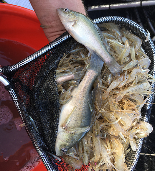
A net full of golden perch (Macquaria ambigua) and shrimp from Yanga Lake