The rivers and wetlands of inland New South Wales are home to a unique array of native plants and animals. They rely on our waterways to survive the boom and bust cycles that shape the Australian landscape.
Water for the environment is a share of the water available in our dams and rivers that is managed to support the ongoing health of our rivers and wetlands.
This Outcomes 2017–18 report details our work to support river systems and meet the needs of native plants, native fish, waterbirds and other water-dependent wildlife so they can be enjoyed by all, now and into the future.
A year in the catchments
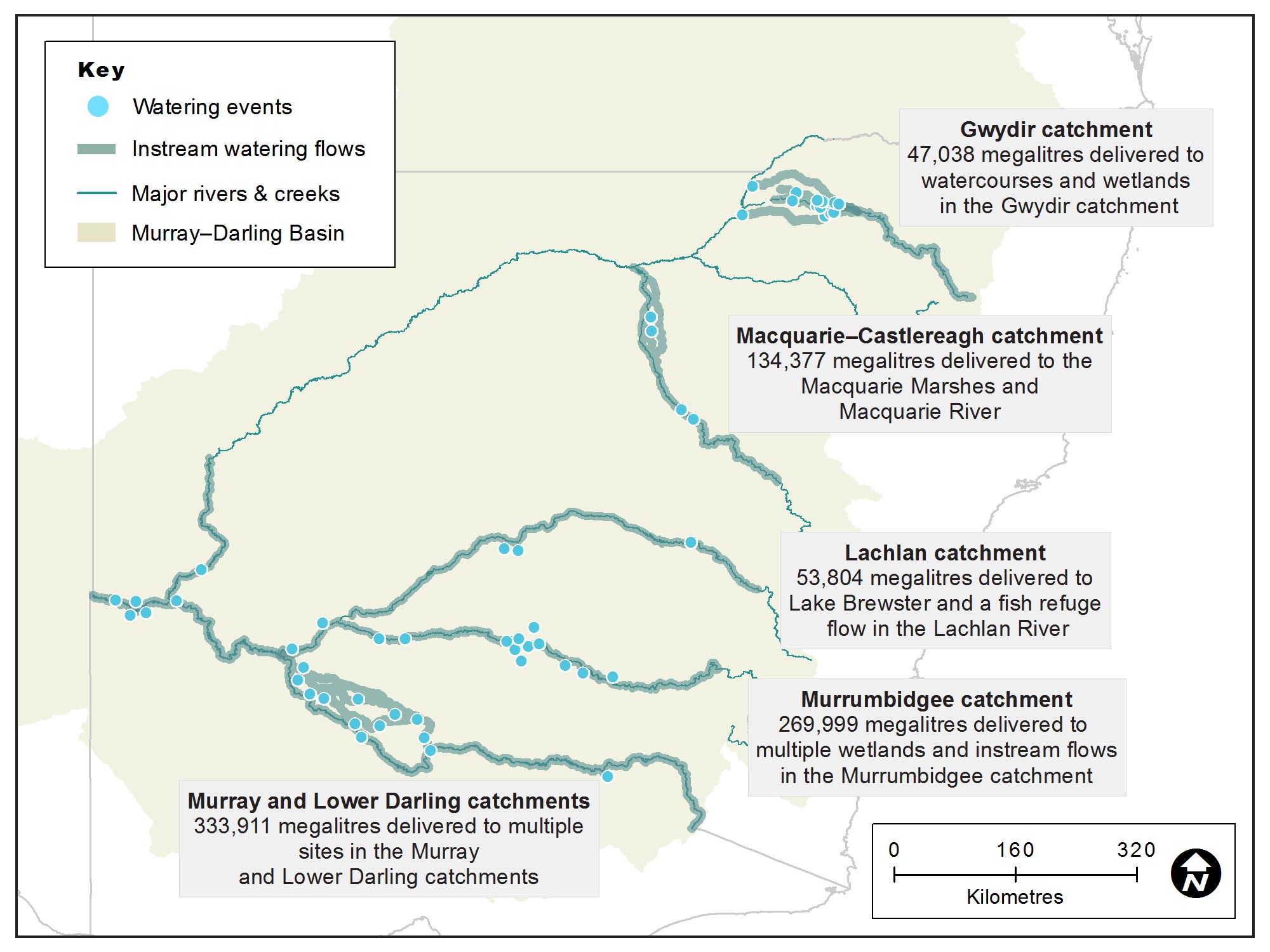
Map of New South Wales showing water catchment areas, associated main waterways and locations of water for the environment deliveries made in 2017–18.
Executive summary
Restoring the health of rivers and wetlands for future generations is the aim of our water for the environment program.
In 2017–18, the Office of Environment and Heritage (OEH) managed the delivery of water for the environment to key sites across the state. We responded to a number of rainfall events by adding water for the environment to natural inflows and enhancing outcomes for native plants and animals. This provided opportunities for native fish and waterbirds to feed and breed, plants to grow and set seed, and floodplains to release essential nutrients into the food chain.
OEH manages water on behalf of the NSW Government, the Commonwealth Environmental Water Office and The Living Murray (TLM) program.
Although warm dry conditions were forecast, the water year began with reasonable reserves of water across much of the state because of widespread rain in 2016.
We worked with community advisory groups to build on the successes of previous years while holding some water in reserve for future dry times.
Water was used strategically to:
- support habitat health
- provide essential refuge sites as the system dried down
- make subtle but important changes to river flow patterns at a number of locations to provide triggers for native fish to breed
- connect rivers with key floodplain wetlands and give native fish increased access to habitat and food.
By the end of 2017, water managers were again planning for dry conditions and low water availability. In consultation with community advisory groups, we put in place adaptive management plans. These plans aim to maintain critical refuge habitat and retain the gains made after the 2016 flood.
Murray and Lower Darling catchments
In 2017–18 we:
- delivered 334 gigalitres of water to rivers, creeks and wetlands on private and public land
- managed a flow in the Lower Darling that triggered Murray cod breeding and enabled this important population to connect with the Murray River, which built on the success of a breeding event in 2016
- worked with partner agencies to manage a delivery of water to connect the Murray River with the Millewa wetlands and Edward–Wakool river system, which connected the river and floodplain, increased access to habitat and boosted food production for native fish as well as encouraging breeding and movement
- used water for the environment to sustain waterbird breeding events and support the endangered southern bell frog
- monitored flows that recharged groundwater reserves, supporting a myriad of wetland plants including our iconic river red gums and Moira grass plains.
Murrumbidgee catchment
In this catchment in 2017–18 we:
- managed watering events that triggered golden perch to breed in significant numbers
- managed a whole-of-system flow, in collaboration with partner agencies, to connect hundreds of wetlands between the mid-Murrumbidgee and Murray junction
- monitored a golden perch breeding event at Yanga Lake that revealed hundreds of thousands of juveniles that likely spawned in the river or Yanga Creek during the whole-of-system flow event; the lake provided the ideal nursery habitat for the young fish to grow and a food source for thousands of pelicans and other birds that fed on the fish
- maintained refuge habitat for native fish, southern bell frogs and turtles as well as waterbird species including the endangered Australasian bittern
- managed a total of 270 gigalitres to support the lifecycle and resource needs of the native plants and animals at home in the catchment.
Lachlan catchment
It was a dry year in the Lachlan catchment with many lakes and ephemeral creeks drying down.
A highlight of the year was the recovery of aquatic plants at the Lake Brewster outflow wetlands. For the first time since the outflow wetlands were constructed, water for the environment provided the trigger for extensive beds of water milfoil, ribbon weed, rushes and water grasses to establish.
In addition to the strong wetland plant response there was another pelican breeding event – for which the outer wetlands provided some important feeding areas for the birds.
Water for the environment was released in spring and early summer in 2017-18 and this:
- provided opportunities for native fish to feed, breed and move along the length of the river
- enhanced flows in the mid-Lachlan anabranch creeks to:
- improve habitat and opportunities for fish to access habitat
- partially inundate reed beds, open water bodies and fringing wetland vegetation at the Great Cumbung Swamp.
Macquarie-Castlereagh catchment
In this catchment in 2017-18 we:
- inundated core semi-permanent wetlands in the Macquarie Marshes; a ‘pre-wet’ flow primed the system and improved water efficiency for a follow-up flow
- inundated semi-permanent wetland plant communities including reed beds, water couch and mixed marsh and river red gum forest; low numbers of waterbirds were recorded breeding
- supported breeding and movement of native fish including Murray cod in the mid-Macquarie River and lower-Macquarie River channels.
Gwydir catchment
The Gwydir catchment contributed flows to the Northern Basin Connectivity event in 2017–18. This joint effort between the NSW and Australian Governments aimed to support river health and connect rivers in the Barwon–Darling system. Water was delivered into the Barwon River via the Gwydir and downstream of the Mehi River and Carole-Gil Gil creeks, giving native fish access to additional food and habitat along the delivery path and creeks within the lower catchment.
Rainfall and dam inflows in the catchment provided triggers for managed watering events. These events, plus follow-up flows and dam releases:
- supported habitat health
- supported breeding and movement of native fish
- supported native fish during a period between high-volume irrigation releases, when rivers were low
- provided more natural flow patterns for the Gingham and Lower Gwydir watercourses
- provided an influx of food to native fish, such as Murray cod and golden perch and allowed them to move into suitable habitat in the lead up to winter.
OEH also managed a delivery of water into the Peel River. This release coincided with releases from the Keepit Dam on the Namoi River, which:
- inundated low lying benches in the Peel River that, when wetted, wash nutrients into the river and stimulates food production
- enabled the connection between the Peel and Namoi River systems, providing the opportunity for fish movement on a larger scale.
Anthony Lean
Chief Executive
Office of Environment and Heritage
Monitoring update
Our monitoring, evaluation and reporting (MER) program captures important data that guides how we manage water for the environment and track our progress toward meeting Basin Plan and NSW environmental watering objectives.
It is designed to meet Open Government principles including transparency, easy access to information, and improved collaboration and participation. Major themes addressed by the program are:
- river flows and connectivity
- native vegetation
- waterbirds
- native fish.
When water for the environment is used it’s monitored to measure native plant and animal outcomes, waterflow movement and extent. Lessons learned from our monitoring program inform future management decisions.
The year in review
We collaborate with other agencies, scientists and communities to build knowledge of the systems where water for the environment is used. In the 2017–18 water year we worked closely with field naturalist groups, bird watchers and independent scientists to:
- increase the number of monitoring sites
- learn more from local experts.
We are also looking at more innovative ways to monitor watering events, such as identifying better methods to determine productivity in rivers.
Whole-of-NSW framework
Our MER program has been developed to help co-ordinate and guide work to determine how water for the environment contributes to achieving environmental outcomes. It provides a framework for the development of a common foundation for MER programs across New South Wales that support sound policy, planning and regulatory decision-making.
This framework also guides individual MER plans for each New South Wales basin catchment and allow us to meet Basin Plan as well as other policy and planning reporting requirements.
NSW water holdings
The Office of Environment and Heritage is the lead agency for the delivery of all water for the environment in New South Wales. This includes water held by the Commonwealth Environmental Water Office.
This table summarises current NSW 'held' water for the environment recovered to 30 June 2018 (megalitres).
| Valley | High security | General security | Supplementary | Unregulated | Total |
|---|---|---|---|---|---|
| Gwydir | 1249 | 17,092 | 3140.5 | – | 21,481.5 |
| Macquarie | – | 48,419 | 1451.5 | 2916 | 52,786.5 |
| Lachlan | 1795 | 37,595 | – | – | 39,390 |
| Murrumbidgee | – | 31,424 | 154,787 | 9948 | 196,159 |
| Murray | 2027 | 30,157 | – | – | 32,184 |
| Barwon–Darling | – | – | – | 1728 | 1728 |
| Subtotal (OEH only) | 5071 | 164,687 | 159,379 | 14,592 | 343,729 |
| The Living Murray (TLM) | 5623.5 | 187,938 | 350,000 | 12,965 | 556,526.5 |
| Total | 10,694.5 | 352,625 | 509,379 | 27,557 | 900,255.5 |
Water trade
OEH’s environmental water business model allows for the periodic trading of water allocation in the accounts of OEH water access licences to pay for some of the costs of managing these licences. Funds may also be used to purchase water or implement small-scale projects that improve environmental watering outcomes.
In 2017–18, OEH sold:
- 500 megalitres of Gwydir allocation
- 800 megalitres of Macquarie allocation
- 1,000 megalitres of Murrumbidgee allocation, and
- 400 megalitres of NSW Murray allocation.
We sold 6,680 megalitres of carryover space in the Murrumbidgee and purchased 1,000 megalitres of carryover space in the NSW Murray.
An agreement was reached with water users to protect high-priority wetlands in the mid-Murrumbidgee reach which involved the transfer of 750 megalitres.
OEH also purchased 2,297 megalitres of Lachlan allocation and used it to support pelicans in Lake Brewster, a site which dried out earlier than expected.
Trade will continue in future to manage the portfolio for maximum environmental benefit.
Partners
We work with a range of partner agencies, organisations and individuals to achieve/secure effective and efficient delivery of water to our rivers and wetlands.
These include, but are not limited to the:
- Commonwealth Environmental Water Office
- Murray-Darling Basin Authority
- Southern Connected Basin Environmental Water Committee
- Environmental Water Advisory Groups
- Department of Industry – Water
- Department of Primary Industries – Fisheries
- Murray Lower Darling Rivers Indigenous Nations
- Northern Basin Aboriginal Nations
- recreational fishers
- landholders
- universities.
Further information about some of our partner agencies is on our terms and definitions webpage.