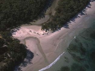
Wowly Gully estuary it is classed as a lagoon with an entrance that is intermittently open and closed to the ocean. Located on the south coast of New South Wales, the estuary forms part of the Jervis Bay Marine Park.
Water quality report card
As part of our water quality monitoring program we assess the water quality and ecosystem health of an estuary using a range of relevant indicators. We sample a subset of the estuaries between Wollongong and the Victorian border every 3 years. The most recent sampling in Wowly Gully was completed over the 2023–24 summer, when 2 sites were sampled on a monthly basis.
This report card represents 2 water quality indicators that we routinely measure: the amount of algae present and water clarity. Low levels of these 2 indicators equate with good water quality. The numerical scores for these 2 indicators are averaged to give the overall grade.
The report card shows the condition of the estuary was excellent with:
- algae abundance graded excellent (A)
- water clarity graded good (B)
- overall estuary health graded good (B).
Go to estuary report cards to find out what each grade means, read our sampling, data analysis and reporting protocols, and find out how we calculate these grades.
We have monitored water quality in Wowly Gully since 2011. This table shows the water quality grades for this estuary over that time.
| Year | Algae | Water clarity | Overall grade |
|---|---|---|---|
| 2023–24 | A | B | B |
| 2011–12 | A | A | A |
| Estuary type | Lagoon |
|---|---|
| Latitude (ºS) | –35 |
| Longitude (ºE) | 150.73 |
| Catchment area (km2) | 6 |
| Estuary area (km2) | 0.2 |
| Estuary volume (ML) | 71 |
| Average depth (m) | 0.4 |
Notes: km2 = square kilometres; m = metres; ML = megalitres.
Water depth and survey data
Bathymetric and coastal topography data for this estuary are available in our data portal.
Land use
The catchment of Wowly Gully is moderately disturbed. About 15% of land use within the catchment is urban development at Callala Bay; the rest of the catchment is undisturbed forest within Jervis Bay National Park.
National and marine parks
- Jervis Bay National Park is the largest conservation area in the Wowly Gully catchment.
- Wowly Gully estuary is located within the Jervis Bay Marine Park. The entrance of the estuary is included in the habitat protection zone for the marine park.
Citizen science projects
- The Budawang Coast Atlas of Life is an online data platform the community can use to record and identify biodiversity.
Community involvement
- Shoalhaven City Council’s Bushcare webpage provides links to a range of active groups in and around this catchment.
- The Shoalhaven Landcare Association represents a range of volunteer groups working in and around the Wowly Gully catchment.
Local government management
Local councils manage estuaries within their area. Where an estuary is attached to a marine park, marine park management teams are responsible for ensuring compliance with marine park zoning.
Shoalhaven City Council manages this estuary which is located in Jervis Bay Marine Park.
Threatened species
Scattered populations of threatened species such as Australian saltgrass and the Jervis Bay leek orchid occur in the Wowly Gully catchment area.
Read more about the biodiversity in our estuaries.