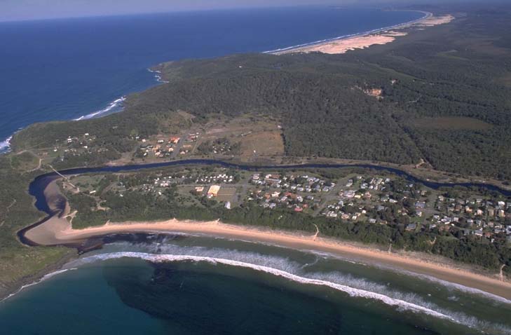
Korogoro Creek is a medium-sized barrier river estuary which meets the sea at Hat Head on the New South Wales mid -north coast. It has an untrained entrance which is permanently open, owing due to its orientation and the protection offered by Korogoro Point.
The upper estuary was extended in the 1960s when drains, floodgates and levees were constructed to help mitigate floods in the Macleay River.
Water quality report card
As part of our water quality monitoring program we assess the water quality and ecosystem health of an estuary using a range of relevant indicators. We sample a subset of the estuaries located between the Queensland border and Taree every 3 years. The most recent sampling in Korogoro Creek was completed over the 2015–16 summer when 2 sites were sampled on a monthly basis.
This report card represents 2 water quality indicators that we routinely measure: the amount of algae present and water clarity. Low levels of these 2 indicators equate with good water quality.
The report card shows the condition of the estuary was fair with:
- algae abundance graded poor (D)
- water clarity graded good (B)
- overall estuary health graded fair (C).
Grades for algae, water clarity and overall are represented as:
- A – excellent
- B – good
- C – fair
- D – poor
- E – very poor.
Go to estuary report cards to find out what each grade means, read our sampling, data analysis and reporting protocols, and find out how we calculate these grades.
We have monitored water quality in Korogoro Creek since 2009. This table shows the water quality grades for this estuary over that time.
| Year | Algae | Water clarity | Overall grade |
|---|---|---|---|
| 2009–10 | C | B | B |
Physical characteristics
| Estuary type | Barrier river |
|---|---|
| Latitude | –31.05 (ºS) |
| Longitude | 153.06 (ºE) |
| Catchment area | 9.5 km2 |
| Estuary area | 0.3 km2 |
| Estuary volume | 123.8 ML |
| Average depth | 0.5 m |
Tidal exchange volume
Tidal exchange volume or tidal prism data is available for this estuary. This tidal prism data was measured in 2005.
| Tide state | Flow (ML) | Local tidal range (m) | Sydney Harbour tidal range (m) |
|---|---|---|---|
| Ebb flow | 200 | 1.17 | 1.79 |
| Flood flow | 180 | 1.18 | 1.59 |
Notes: km2 = square kilometres; m = metres; m3 = cubic metres; ML = megalitres.
Water depth and survey data
Bathymetric and coastal topography data for this estuary are available in our data portal.
Land use
The catchment of Korogoro Creek is relatively undisturbed with swamps and forests making up about 90% of the catchment area. The estuary is nestled along the coast and is completely dwarfed by the adjoining Macleay Valley. Hat Head village is the only town in the area, and its footprint covers about 8% of the catchment.
National and marine parks
- Hat Head National Park is the largest conservation area in the Korogoro Creek catchment.
- This estuary does not flow into a marine park.
Community involvement
- Hat Head Dunecare Group is a volunteer group that works to improve the natural environment around Hat Head.
Local government management
Local councils manage estuaries within their area unless the estuary is attached to a marine park.
Korogoro Creek is managed by Kempsey Shire Council. More information about this estuary can be found on the council’s Korogoro Creek estuary webpage.
Threatened species
Korogoro Creek estuary supports coastal saltmarsh, which is an endangered ecological community.
Read more about the biodiversity in our estuaries.