About the bioregion
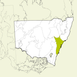
The Sydney Basin bioregion extends from just north of Batemans Bay to Nelson Bay on the central coast, and almost as far west as Mudgee. It is bordered to the north by the North Coast and Brigalow Belt South bioregions, to the south by the South East Corner bioregion and to the west by the South Eastern Highlands and South Western Slopes bioregions.
It includes a significant proportion of the catchments of the Hawkesbury-Nepean, Hunter and Shoalhaven river systems, all of the smaller catchments of Lake Macquarie, Lake Illawarra, the Hacking, Georges and Parramatta rivers, and smaller portions of the headwaters of the Clyde and Macquarie rivers.
The climate is mostly temperate with warm summers and no dry season, with the coastal and Hunter regions being warmer than the higher plateaux and western edge.
There are more than 200 threatened animal and plant species in the Sydney Basin bioregion, including the critically endangered Wollemi pine (Wollemia nobilis) which only grows in a restricted part of the Wollemi National Park. Threatened animals include the brush-tailed rock-wallaby (Petrogale penicillata), koala (Phascolarctos cinereus) and powerful owl (Ninox strenua).
National parks and nature reserves make up about 35% of the bioregion and the World Heritage listed Blue Mountains make up over one million hectares of the Sydney Basin bioregion. The Ramsar-listed Towra Point Nature Reserve and Hunter Estuary Wetlands are in this bioregion.
Read Chapter 15, the Sydney Basin Bioregion, in Bioregions of New South Wales: Their biodiversity, conservation and history for more information.
Bioregion area
- 3,629,597 hectares in total
- 3,622,939 hectares in New South Wales (the remainder in the Australian Capital Territory)
Parks, reserves and protected areas
This bioregion includes:
- Bangadilly National Park
- Bargo State Conservation Area
- Barren Grounds Nature Reserve
- Bents Basin State Conservation Area
- Berowra Valley National Park
- Blue Mountains National Park
- Bouddi National Park
- Brisbane Water National Park
- Budderoo National Park
- Burning Mountain Nature Reserve
- Cambewarra Range Nature Reserve
- Cattai National Park
- Cecil Hoskins Nature Reserve
- Conjola National Park
- Dalrymple-Hay Nature Reserve
- Dharawal National Park
- Dharug National Park
- Garawarra State Conservation Area
- Gardens of Stone National Park
- Garigal National Park
- Georges River National Park
- Glenrock State Conservation Area
- Goulburn River National Park
- Gulguer Nature Reserve
- Heathcote National Park
- Illawarra Escarpment State Conservation Area
- Jerrawangala National Park
- Kamay Botany Bay National Park
- Kanangra-Boyd National Park
- Ku-ring-gai Chase National Park
- Lake Macquarie State Conservation Area
- Lane Cove National Park
- Leacock Regional Park
- Macquarie Pass National Park
- Meroo National Park
- Morton National Park
- Munghorn Gap Nature Reserve
- Munmorah State Conservation Area
- Muogamarra Nature Reserve
- Murramarang Aboriginal Area
- Murramarang National Park
- Narrawallee Creek Nature Reserve
- Nattai National Park
- Parr State Conservation Area
- Popran National Park
- Robertson Nature Reserve
- Rouse Hill Regional Park
- Royal National Park
- Scheyville National Park
- Seven Mile Beach National Park
- Sydney Harbour National Park
- Thirlmere Lakes National Park
- Tomaree National Park
- Towarri National Park
- Towra Point Nature Reserve
- Wallumatta Nature Reserve
- Watagans National Park
- William Howe Regional Park
- Wollemi National Park
- Wolli Creek Regional Park
- Wyrrabalong National Park
- Yellomundee Regional Park
- Yengo National Park
- Yerranderie Regional Park.