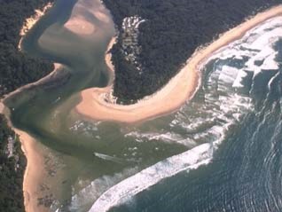
St Georges Basin is located on the south coast of New South Wales near Jervis Bay. It is classed as a lake which is permanently connected to the sea via a narrow channel adjacent to the township of Sussex Inlet.
The main tributaries to St Georges Basin are the Wandandian and Tomerong creeks. Several towns surround this large waterbody, which is a popular fishing spot.
Water quality report card
As part of our water quality monitoring program we assess the water quality and ecosystem health of an estuary using a range of relevant indicators. We sample a subset of the estuaries between Wollongong and the Victorian border every 3 years. The most recent sampling in St Georges Basin was completed over the 2023–24 summer, when 2 sites were sampled on a monthly basis.
This report card represents 2 water quality indicators that we routinely measure: the amount of algae present and water clarity. Low levels of these 2 indicators equate with good water quality. The numerical scores for these 2 indicators are averaged to give the overall grade.
The report card shows the condition of the estuary was excellent with:
- algae abundance graded excellent (A)
- water clarity graded excellent (A)
- overall estuary health graded excellent (A).
Grades for algae, water clarity and overall are represented as:
- A – excellent
- B – good
- C – fair
- D – poor
- E – very poor.
Go to estuary report cards to find out what each grade means, read our sampling, data analysis and reporting protocols, and find out how we calculate these grades.
We have monitored water quality in St Georges Basin since 2008. This table shows the water quality grades for this estuary over that time.
| Year | Algae | Water clarity | Overall grade |
|---|---|---|---|
| 2023-24 | A | A | A |
| 2008–09 | A | A | A |
Physical characteristics
| Estuary type | Lake |
|---|---|
| Latitude (ºS) | –35.19 |
| Longitude (ºE) | 150.59 |
| Catchment area (km2) | 315.8 |
| Estuary area (km2) | 40.9 |
| Estuary volume (ML) | 215,078.9 |
| Average depth (m) | 5.3 |
Tidal exchange volume
Tidal exchange volume or tidal prism data is available for this estuary. This tidal prism was measured in 2001.
| Tide state | Flow (ML) | Local tidal range (m) | Sydney Harbour tidal range (m) |
|---|---|---|---|
| Ebb flow | 390 | 0.54 | 1.22 |
| Flood flow | 300 | 0.49 | 1.24 |
Notes: km2 = square kilometres; m = metres; m3 = cubic metres; ML = megalitres.
Water depth and survey data
Bathymetric and coastal topography data for this estuary are available in our data portal.
Land use
The catchment of St Georges Basin has relatively low disturbance, with over 70% forested areas, including part of Morton National Park. Urban areas make up almost 10% of the catchment and include the townships of St Georges Basin, Sanctuary Point and Sussex Inlet. Cleared land for grazing accounts for less than 10% of land use.
Web cam
The Sussex Inlet bar crossing web camera provides real-time video of conditions within the river entrance immediately offshore to help with bar crossings and boat safety.
National and marine parks
- Morton National Park is the largest conservation area within this catchment.
- This estuary does not flow into a marine park.
Citizen science projects
- The Budawang Coast Atlas of Life is an online data platform the community can use to record and identify biodiversity.
Community involvement
- The Shoalhaven Landcare Association represents a range of volunteer groups working in and around this catchment.
- South East Landcare is an umbrella organisation that represents a network of Landcare associations including those in the Shoalhaven area.
Local government management
Local councils manage estuaries within their area. Where an estuary is attached to a marine park, marine park management teams are responsible for ensuring compliance with marine park zoning.
Shoalhaven City Council manages this estuary.
Threatened species
The St Georges Basin catchment contains a stronghold for the critically endangered orchid, Pterostylis ventricosa.
Find out more about the biodiversity in our estuaries.