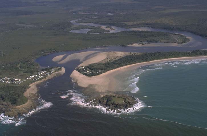
The Sandon River flows through Yuraygir National Park into the sea between Brooms Head and Wooli on the New South Wales north coast. The entrance is flanked by 2 rocky headlands which act as natural training walls. This estuary is classed as a medium-sized barrier river.
The Sandon River represents a relatively undisturbed system. Most of the catchment is protected under national park management or managed by forestry. Candole Creek and Toumbaal Creek converge with the Sandon River to form the lower estuary where extensive tidal flats provide abundant habitat for shorebirds and crustaceans.
Water quality report card
As part of our water quality monitoring program we assess the water quality and ecosystem health of an estuary using a range of relevant indicators. We sample a subset of the estuaries located between the Queensland border and Taree every 3 years. The most recent sampling in the Sandon River was completed over the 2021–22 summer, when 2 sites were sampled on a monthly basis.
This report card represents 2 water quality indicators that we routinely measure: the amount of algae present and water clarity. Low levels of these 2 indicators equate with good water quality.
The report card shows the condition of the estuary was good with:
- algae abundance graded good (B)
- water clarity graded good (B)
- overall estuary health graded good (B).
Grades for algae, water clarity and overall are represented as:
- A – excellent
- B – good
- C – fair
- D – poor
- E – very poor.
Go to estuary report cards to find out what each grade means, read our sampling, data analysis and reporting protocols, and find out how we calculate these grades.
We have monitored water quality in Sandon River since 2007. This table shows the water quality grades for this estuary over that time.
| Year | Algae | Water clarity | Overall grade |
|---|---|---|---|
| 2007–08 | A | B | B |
| 2009–10 | B | B | B |
| 2012–13 | B | C | B |
| 2015–16 | A | B | A |
| 2018–19 | B | B | B |
Physical characteristics
| Estuary type | Barrier river |
|---|---|
| Latitude (ºS) | –29.67 |
| Longitude (ºE) | 153.33 |
| Catchment area (km2) | 131.5 |
| Estuary area (km2) | 2.6 |
| Estuary volume (ML) | 2393.5 |
| Average depth (m) | 1.1 |
Tidal exchange volume
Tidal exchange volume or tidal prism data is available for this estuary. This tidal prism was measured in 1980.
| Tide state | Flow (ML) | Local tidal range (m) | Sydney Harbour tidal range (m) |
|---|---|---|---|
| Ebb flow | 2,940 | 1.45 | 1.5 |
| Flood flow | 3,250 | 1.55 | 1.4 |
Notes: km2 = square kilometres; m = metres; m3 = cubic metres; ML = megalitres.
Water depth and survey data
Bathymetric and coastal topography data for this estuary are available in our data portal.
Land use
Sandon River drains an almost entirely forested catchment which lies within Yuraygir National Park and Forestry Corporation land. The small village of Sandon and a busy camping area are located at the entrance of the estuary.
National and marine parks
- Sandon River estuary is located within Yuraygir National Park and forms part of the Solitary Islands Marine Park.
Citizen science projects
- Clarence Valley Council runs the Caring for our Coastal Emus project, which includes an online emu register that community members can report where they’ve seen coastal emus.
Community involvement
- Clarence Landcare supports volunteer groups working to improve the environment in this region, including the Sandon River Environmental Alliance.
Local government management
Local councils manage estuaries within their area unless the estuary is attached to a marine park. Clarence Valley Council manages the Sandon River, which is part of the Solitary Islands Marine Park.
Threatened species
The vast tidal flats of Sandon River estuary provide abundant habitat for shorebirds, including the endangered Australasian bittern.
The Sandon River area provides a stronghold for an endangered population of coastal emus, whose range continues to contract.
Read more about the biodiversity in our estuaries.