Plant community type data (archived 15 June 2022)
The revised Plant Community Types (PCT) master list (version C1.1) was released in BioNet on 24 June 2022. This spreadsheet contains a copy of the PCT data held in BioNet before 15 June 2022.
Application of the revised PCT classification (version C1.1) to the Biodiversity Offsets Scheme (BOS) and Biodiversity Assessment Method (BAM) is delayed for at least 6 months after the public release to allow stakeholders to become familiar with the new scientific data in BioNet.
Accredited assessors require access to archived PCT data until the revised PCT classification is operationalised in the BAM Calculator and the transitional arrangements have ended. This spreadsheet is intended for use primarily by BOS accredited assessors to look up PCTs to facilitate the completion of BAM assessments commenced before the BAM Calculator update.
This archive will be removed following application of the revised PCT classification (version C1.1) to the BOS and BAM Calculator.
Download BioNet archive plant community type data preC1.1.
Over-cleared Vegetation Types (archived 17 August 2017)
BioMetric and Threatened Species Profiles datasets were originally defined under the repealed Native Vegetation Act 2003 and the Environmental Outcomes Assessment Methodology.
Over-cleared vegetation types, otherwise known as BioMetric Vegetation Types (BVT), were a list of vegetation communities that occurred within each NSW catchment management authority (CMA) region.
BioMetric Vegetation Types were retired from the BioNet Vegetation Classification (previously known as VIS Classification) on 21 August 2017 and replaced with Plant Community Types (PCTs) for the commencement of the Biodiversity Conservation Act 2016. Reasons for this change include:
- to simplify the NSW vegetation classification system
- to facilitate development of quantitative PCTs and seamless statewide Plant Community Type mapping.
Download Archived over-cleared vegetation types data (XLSX 2MB).
A brief history of community-level classification in New South Wales
Before 2003, there was no centrally managed fine-scale statewide vegetation classification schema available for New South Wales.
Efforts to prepare a consolidated master list of vegetation types for New South Wales began with the development of the NSW vegetation classification and assessment (NSW VCA) project (Benson 2006). The project started in the western plains regions (Benson et al. 2006) and incrementally extended east into the NSW South Western Slopes (Benson 2008) and the Brigalow Belt South and Nandewar bioregions (Benson et al. 2010). The original VCA databases were migrated into and superseded by the VIS Classification (now BioNet Vegetation Classification) in 2011.
New decision support tools for natural resource management were introduced under NSW legislation in 2003. Operation of these tools required an inventory of fine-scale vegetation classification units for each catchment management authority region defined in New South Wales at that time. The classification units developed were named BioMetric Vegetation Types (BVTs).
The inventory sourced the best fine-scale classifications available at the time, which were assembled and interpreted by regional ecologists to define plausible units representing recognisable vegetation patterns for each catchment. The NSW VCA units were adopted as BVTs in most catchments of the western plains and slopes.
In eastern New South Wales, several separate large regional plot-based classification projects covered most of the area. The process of compiling a set of BVTs from multiple competing classification projects involved interpretations, with no overarching framework applied across catchments.
After initial compilation, periodic revisions to BVTs were undertaken to add to the inventory for each catchment and modify or replace types.
In 2011 the Plant Community Type schema was adopted. PCTs were created by combining related BVTs across adjoining catchments, using an alignment process and expert review. Duplicate PCTs were commonly created due to the inability to reconcile all BVTs across catchment boundaries.
BVTs were used in regulatory tools until August 2017, when they were entirely replaced by PCTs. Among other benefits, the change from BVTs to PCTs removed some of the complexity of managing a classification system against administrative boundaries.
All changes and updates to the PCTs are managed through the BioNet Vegetation Classification application.
How do PCTs relate to BioMetric Vegetation Types?
BioMetric Vegetation Types (BVTs) were the vegetation communities used in the biodiversity assessment tool BioMetric, which underpinned Property Vegetation Plans under the repealed Native Vegetation Act 2003 and Environmental Outcomes Assessment Methodology, and the BioBanking Credit Calculator.
The BVT classification focused on the occurrence of plant communities within catchment management authority (CMA) areas. Each community was assigned a BVT ID for each CMA occurrence (such as in the diagram below). The PCT classification was developed in 2011 to represent the full geographic distribution of each plant community. A PCT may have been distributed across one or more CMA administration areas, allowing a small set of CMA-specific attributes (for example, percentage of the vegetation type remaining in the CMA) to be managed at the CMA level. All other community attributes were recorded at the PCT level.
When BVTs needed to be updated in the BioMetric-based regulatory tools (such as the BioBanking Credit Calculator), a combination of PCT and CMA-specific attributes were exported from the VIS Classification (version 2.0) database in the format required by the BioMetric tools.
The PCT classification was derived initially by associating and aligning BVTs sourced from the native vegetation regulation database PADACS (Property Vegetation Plans, including agreements, data and customer service). This was done to minimise the impact on the existing regulatory tools and processes by eliminating unnecessary changes to the pre-existing BVTs. Some minor changes occurred as a consequence of standardising common attributes between BVTs, such as plant community names.
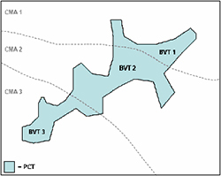
BioMetric Vegetation Types classification in catchment management authority
Vegetation condition benchmarks
Vegetation condition benchmarks transitioned to a new quantitatively derived benchmark system on 21 August 2017.
Download Archived vegetation condition benchmark data (XLSX 476KB).
Threatened Species Profiles Database
The Threatened Species Profiles Database (TSPD) was a module in BioNet Atlas until 21 August 2017. The name of this module was changed to Threatened Biodiversity Profiles data collection, and a number of core attributes used to calculate biodiversity credits were changed.
Download:
- Archived TSPD credit calculator data (XLSX 486KB)
- Archived TSPD vegetation association data (XLSX 3.8MB)
- Archived TSPD response to management data (XLSX 514KB).
Over-cleared landscapes
Over-cleared landscapes data remain unchanged following the introduction of the Biodiversity Conservation Act 2016 on 25 August 2017.
The over-cleared landscape values comprise the percentage-cleared estimate for each NSW Landscape (formerly known as Mitchell Landscape). This data set is framed around a threshold of 70% cleared per landscape. To obtain these estimates, the landscapes were intersected with a presence/absence layer of native vegetation in New South Wales.
The ecosystem classification used for this purpose (NSW Landscapes) is mapped at a 1:250,000 scale. In 2006, the NSW vegetation presence/absence mask was updated and intersected with the NSW Landscapes layer to produce revised percentage-cleared estimates for each NSW Landscape.
In 2008, the Mitchell Landscapes line work was systematically reviewed and revised where necessary, at 1:100,000 scale. Download Mitchell Landscapes final report (PDF 10.8MB).
Access to the most up-to-date, comprehensive and approved 'over-cleared landscapes' data is via BioNet Vegetation Classification. Refer to the User manual for instructions on exporting data from the application.
Access the latest NSW Mitchell Landscapes v3.1 layer, which is now maintained with over-cleared landscape values included.