Why is land and soil information important?
Soils are an important, non-renewable natural resource. Healthy soils support a healthy environment: they support plant and animal productivity and biodiversity, promote water and air quality and underpin our food and fibre supplies, so they are vital for our survival.
To productively and sustainably manage our land and soils, we need to know where our best and worst landscapes and soils are, and what we can do with them without causing degradation. For this, we need a comprehensive, high-quality, accessible resource of soil and land information.
What information do we hold?
The Department of Climate Change, Energy, the Environment and Water (the department) collects and manages 2 major types of soil and land information.
Soil profiles
A soil profile is a column of soil going vertically downwards from the surface to a certain depth at a particular location. This column of soil is described and tested, including (in some cases) collection of samples for testing at a laboratory.
The soil description and test results, along with features of the site and local area, are recorded in the NSW Soil and Land Information System (SALIS), a database of soil information from across New South Wales that is managed by the department. Contextual information may include assessments of:
- landform
- geology
- hydrology
- native vegetation
- land use
- land and soil degradation.
More than 73,000 profiles are stored in SALIS, of which about two-thirds are publicly available. The information is collected by the department field staff and many other contributors, who add thousands of collection points each year.
Landscape and soil mapping
We map soils and landscapes to understand their distribution, the processes by which they develop, their capability and suitability for various uses, what risks may be involved and how they can be safely addressed.
This information is important for both the direct users of land and soils and for more strategic purposes, such as planning and policy making, environmental protection, and improvement of or adaptation to large-scale environmental problems such as climate change, soil erosion, acidification and dryland salinity. Recently, the department's soil and landscape mapping has provided the foundation for the NSW Government’s identification of the state’s best land and soils through its mapping of biophysical strategic agricultural land – see Safeguarding our agricultural land.
The department manages mapping from a number of programs, collected in various areas of New South Wales at different scales for various purposes. An increasing majority of these datasets are stored in SALIS and available on eSPADE. You can find more information about them on the About soil maps page.
How do we manage land and soil information?
We have developed a suite of online systems for collecting, storing and accessing soil and land information.
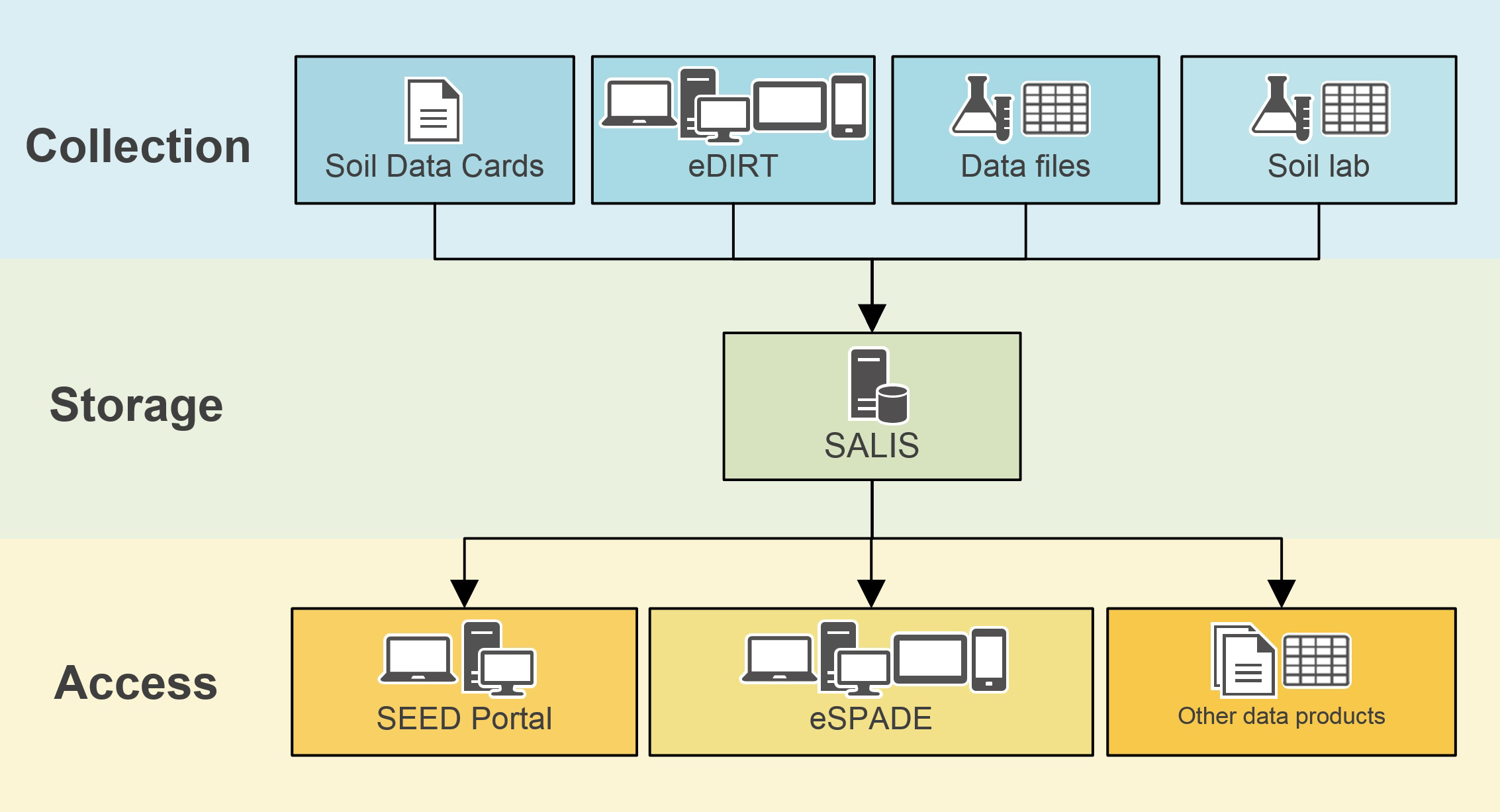
- You can use eDIRT to record soil profile information in digital form in the field and store it in SALIS.
- You can still use the scannable hard-copy Soil Data Cards to record soil profile information.
- Laboratory soil test data can be supplied in spreadsheet form or uploaded directly from the laboratory’s information management system (for participating laboratories only).
- We use the Soil and Land Information System (SALIS) to securely store land and soil information from across New South Wales. The data has been collected over many years by technical experts to help organisations and individuals plan the management of natural resources.
- You can access information from SALIS through eSPADE.
- If you are a data supplier or data owner, you can manage your own data through the SALIS application itself.
- You can access soil and land information from across New South Wales using the eSPADE spatial viewer. Built on the Google Maps™ platform, eSPADE allows you to go to a specific place or area in New South Wales and view interactive maps and other information about its landscapes and soils. The information is sourced mainly from SALIS. eSPADE is free to access on a wide variety of fixed and mobile devices.
- You can search for and download spatial data and related maps, reports and metadata from soil and landscape mapping programs via the SEED (Sharing and Enabling Environmental Data) portal.
- You can request customised data outputs such as spreadsheets and spatial data layers for your area of interest in New South Wales by email to [email protected].
SoilTalk! news
Stay up to date on the latest news and events about landscapes, soils and systems in New South Wales.