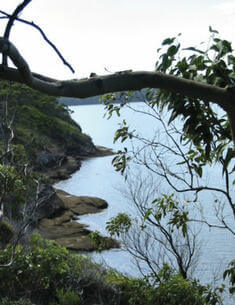
A NSW Government website

Park management documents

Filter results
Showing results 501 - 510 of 1467 results
Preview Image
01 Nov 2003
PDF 83.57 KB
Duval Nature Reserve is located on the central New England Tablelands, approximately 15 kilometres north of Armidale. The reserve encompasses the eastern section of the summit plateau and steep southerly and easterly slopes of Mount Duval, which is a prominent landscape feature in the area.
Plan of management Final
Preview Image
01 May 2010
PDF 307.38 KB
Manobalai Nature Reserve is located 20 kilometres west of Muswellbrook and about 200 kilometres north-west of Sydney. The reserve is 3758 hectares in size and directly adjoins a large area of Crown land to the south. The nature reserve and Crown land form part of an important vegetation corridor, with Goulburn River National Park to the south-west and Wollemi National Park to the south.
Plan of management Final
Preview Image
01 Feb 2011
PDF 777.11 KB
Coxcomb, Goonook and Killabakh Nature Reserves are located approximately 25 kilometres north of Taree on the Mid North Coast of New South Wales. All three reserves were established in 1999 as a result of the Lower North East Regional Forest Agreement and have a combined area of approximately 3,700 hectares.
Plan of management Final
Preview Image
09 Sep 2019
PDF 1.07 MB
The park is located 38 kilometres, by road, west of the town of Barraba and 10 kilometres east of Mount Kaputar National Park on the north-west slopes of the New England Tablelands in New South Wales.
Plan of management Final
Preview Image
04 Oct 2022
PDF 1.38 MB
Ngambaa Nature Reserve is located approximately 10 kilometres south-west of Macksville and 16 kilometres north-west of Kempsey, on the mid-north coast of New South Wales. The reserve covers an area of approximately 10,560 hectares.
Plan of management Final
Preview Image
01 May 2005
PDF 1.62 MB
Yanununbeyan National Park, Yanununbeyan Nature Reserve and Yanununbeyan State Conservation Area are located 25 kilometres south-east of Queanbeyan and 5 kilometres north-west of Captains Flat. The national park (3,500 hectares) and nature reserve (40 hectares) were gazetted in 2001, and the state conservation area (4,135 hectares) was gazetted in 2003.
Plan of management Final
01 Nov 1998
PDF 969.93 KB
Cudgen Nature Reserve is 464 hectares in extent and is located on the Tweed Coast in far north-eastern NSW. The nature reserve is part of a remnant of native vegetation which is recognised as the only area large enough to be capable of providing long term protection to native plant and animal communities on the Tweed Coast.
Plan of management Final
01 Oct 1998
PDF 54.92 KB
Mount Imlay National Park is located in the far south coast hinterland of New South Wales, approximately 20 kilometres south-west of Eden. It has an area of 3,808 hectares and consists of steep, deeply dissected forested country around the peak of Mount Imlay.
Plan of management Final
Preview Image
01 Aug 2009
PDF 5.6 MB
This conservation management plan for the La Perouse Headland within Botany Bay National Park addresses the whole of the La Perouse headland area, including Bare Island.
Conservation management plan Final
Preview Image
01 Dec 2011
PDF 276.46 KB
Currys Gap State Conservation Area, Mount Mackenzie Nature Reserve and Doctors Nose Mountain Nature Reserve are located on the Northern Tablelands of New South Wales, south west of Tenterfield. Currys Gap State Conservation Area covers an area of 227 hectares, Mount Mackenzie Nature Reserve is 141 hectares in size, and Doctors Nose Mountain Nature Reserve is 66 hectares.
Plan of management Final